Click here for more info on on SMS!

KPIE

ST PETERSBURG-CLEARWATER INTL
ST PETERSBURG-CLEARW
FL
Time Zone: Eastern
Lat: N 2754.5
Long: W 08241.2
Elev: 11
Var: +05
Longest Runway: 9730
Clr Del: 120.6
Dept. ATIS: 134.5
Arr. ATIS: 134.5
AWOS: 134.5
Ground: 121.9
Tower: 118.3/128.4

FBO & Flight Services info for KPIE

FBOs: Update your Fuel Prices

  click here  
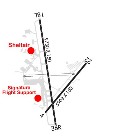
St. Petersburg's preferred FBO partner for service beyond compare! All guests enjoy on-field U.S. Customs, superior ground support and concierge services, complimentary interior cleaning, catering, crew cars, canteen market and complimentary refreshments, executive conference rooms, well-appointed pilot and passenger lounges, and major hotels and restaurants within walking distance.
Ph: 727-530-3453 Fax: 727-535-4372 Freq: 131.97WebsiteE-Mail
                     
Service
Jet
100LL
SAF
MoGas
Fuel Avail: JET A w/ Prist $7.22/gal.
Full7.159.45    Last Update: 04/15/2024 22:11

Call us for special fuel pricing!
Self        
Misc. Info: Hours of Operation: 0600-2200 w/ 24 Hour Call Out Service (Fee Applies).Address: 15875 FAIRCHILD DR   CLEARWATER, FL 33762

CLEARWATER AVPh: 727-538-0318 Fax: 727-510-6812
-
Service
Jet
100LL
SAF
MoGas
Fuel Avail: ~~MAINT ONLY NO FUEL SOLD
Full        Last Update: 04/19/2024 00:01:44  
Self        
SIGNATUREPh: 727-531-1441 Fax: 727-536-6567 Freq: 130.37
Service
Jet
100LL
SAF
MoGas
Fuel Avail: Prist +$0.10. Not including taxes VOLUME DISCOUNTS AVAILABLE.
Full7.327.81    Last Update: 04/19/2024 07:53  
Self        
 Address: 14525 AIRPORT PARKWAY   CLEARWATER, FL 33762
ASOSPh: 727-531-3456
-
-
 
If you are an FBO, call 1-203-262-1700 to update your info or email: FltPlan.Advertising@garmin.com
Advertise your FBO on FltPlan.com

Runway & Approach Info for KPIE
Rwy
Length
Land Dist**
Approach*
  Rwy
Length
Land Dist**
Approach*
04
6000x150  6000'          
 
  
22
  6000x150  6000'          
 
18
9730x150  9730'          
ILS/DME
 109.10 - 176°  
  
36
  9730x150  8800'          
ILS/DME
 108.70 - 356°  
 * only ILS, LOC, LDA, and SDF approaches to a specific runway are shown
** For any Declared Landing Distance Available, please see A/FD or Approach plates
Runway Weight Capability (lbs.) Help
Runway IDSingle WheelDouble WheelDouble Tandem WheelDual Double Wheel
04/2280,000130,000235,000N/A
18/3675,000195,000320,000700,000
These numbers are Advisory and are not limits.   The Airport Manager should have more accurate Weight Limits
Approach Charts
Approaches    
Current Weather/Notams
Customs Information Send updates to Support@FltPlan.com
Phone 727-453-7080
Fax 727-538-0693

Comments Mon-Fri 1130-1930 *1 hrs advance notice required 2 hrs after hours *Maximum passengers per flight: 15 *Prior approval required. *Landing rights and overflight required. *Call prior to 1700 on preceding weekday.
Database effective 04/18/2024
Airport Diagram of KPIE
Airport Diagram might not be current.

Facility Name: ST PETE-CLEARWATER INTL
City Name: ST PETERSBURG-CLEARWATER
County: PINELLAS
State abbrev: FL
State Name: FLORIDA
   
Ownership: PUBLICLY OWNED
Use: OPEN TO THE PUBLIC
Owner's Name: COUNTY OF PINELLAS
Address: ST. PETE-CLEARWATER INTERNATIONAL, TERMINAL BLVD. SUITE 221
 CLEARWATER, FL 33762
Owner's Phone: 727-453-7800
  
Manager's Name: THOMAS JEWSBURY
Address: ST PETE-CLEARWATER INTERNATIONAL
 CLEARWATER, FL 33762
Phone: 727-453-7800
   
FAA Region: SOUTHERN
FAA Field Office: ORL


Sunrise / Sunset times for ST PETE-CLEARWATER INTL

DateSunriseSunset
04/19/24 Friday7:0119:59
04/20/24 Saturday7:0019:59
04/21/24 Sunday6:5920:00
04/22/24 Monday6:5820:00
04/23/24 Tuesday6:5720:01
04/24/24 Wednesday6:5620:01
04/25/24 Thursday6:5620:02
04/26/24 Friday6:5520:03
04/27/24 Saturday6:5420:03
04/28/24 Sunday6:5320:04
04/29/24 Monday6:5220:04
04/30/24 Tuesday6:5120:05
05/01/24 Wednesday6:5020:06
05/02/24 Thursday6:5020:06

Airport Facilities

Airport Attendance ScheduleCONTINUOUS
Airport Status OPERATIONAL (This Status can change at any time - please check NOTAMS)
Airport Lighting ScheduleWHEN ATCT CLSD ACTVT MALSR RWY 18; TDZ RWY 18; CNTLN RWY 18/36; MIRL RWY 04/22; HIRL RWY 18/36; TWY LGTS - CTAF.
Airport Storage AvailableTie Downs, Hanger
Extra Services AvailableAir Freight, Air Ambulance, Charter, Flight Instruction, Aircraft Rental
Wind IndicatorYES - (lighted)
Control TowerYES
CTAF Frequency118.300
Unicom Frequency122.950
Rotating Beacon ColorWG
Segmented CircleNO
Landing FeeNO

Airport Inspection Data

Airport InspectedFEDERAL - performed by FAA AIRPORTS FIELD PERSONNEL
Inspection Date02/22/2024

Airport Services

Type of Fuel AvailableGrade 100, JET A (freeze point -40C), JET A-1 (icing inhibitor, freeze point -50C)
Airframe Repair ServiceMAJOR
Power Plant Repair ServiceMAJOR

Geographic Data

LatitudeN2754.5
LongitudeW08241.2 (ESTIMATED)
Arpt Elevation10ft (SURVEYED)
Magnetic Variation05W
8 miles Nof ST PETERSBURG-CLEARWATER
Traffic Pattern Altitude
Sectional ChartMIAMI

Aircraft Data

Operations (Reported)YearlyAvg. Daily
General Aviation Transient 43315119
General Aviation Local 77255212
Air Taxi 2109658
Commerical 1548642
Commuter 00
Military 745020
Aircraft based on Field
General Aviation Singles 154
General Aviation Multi 45
Jet Aircraft 59
General Aviation Helicopters 3
Military Aircraft 18
Gliders 0
Ultralights 0

FAA Services

FSS on field NO
FSS tie-in SAINT PETERSBURG
FSS Phone 1-800-WX-BRIEF
Who issues Notams PIE
Notam D service at airport YES
ARTCC Name MIAMI

Federal Status

Airport CertificationAIRPORT RECEIVING SCHEDULED AIR CARRIER SERVICE FROM CARRIERS CERTIFICATED BY THE CIVIL AERONAUTICS BOARD
Aircraft Rescue & Firefighting IndexAIRPORT HAS A CERTIFICATE UNDER CFR PART 139
Airport of EntryNo
Custom Landing RightsYES
Joint Civil/MilitaryNo
Military Landing rightsYES

Federal Agreements

NATIONAL PLAN OF INTEGRATED AIRPORT SYSTEMS (NPIAS)
GRANT AGREEMENTS UNDER FAAP/ADAP/AIP
SURPLUS PROPERTY AGREEMENT UNDER PUBLIC LAW 289
SURPLUS PROPERTY AGREEMENT UNDER REGULATION 16-WAA
ASSURANCES PURSUANT TO TITLE VI, CIVIL RIGHTS ACT OF 1964
AGREEMENT UNDER DLAND OR DCLA HAS EXPIRED.

Remarks

BANNER TOWING NA.
BIRDS ON & INVOF ARPT.
FOR CD IF UNA TO CTC ON FSS FREQ, CTC TAMPA APCH AT 813-878-2528.
PPR RQRD FOR ALL TRANS ACFT REQUESTING TO PRK ON CLEARWATER USAR MIL RAMP/APRON. MUST CTC CLEARWATER ARMY SUPPORT FAC OPS AT (910)-771-3046 OR ASF MACDILL AT (813)-828-3183/3180 UP TO 7 DAYS BFR ARR. MIN NOTICE IS 24 HOURS BFR ARR. 1000Z-0300Z M-TH OR FRI 1000Z-1830Z EXCLUDING HOLIDAYS & WEEKENDS.
NOISE SENSITIVE AREA 5 MI N EXTDG 1 MI E & W OF LOC SB TO SHORELINE.
MILITARY: CONTRACT AVOIL O-128 AVBL.
TBJT LNDG RWY 18 & DEP RWY 36 USE PUBLD NOISE ABATEMENT PROC.
LGTS ON HWY N OF ARPT MAY BE MISTAKEN FOR RWY LGTS.
Airport Communications & Frequencies:
ATIS Frequencies:   Hours(local) of Operation: CONTINUOUS
134.5
ST. PETERSBURG-CLEARWATER Tower Frequencies:   Hours(local) of operation: 0600-2300   
118.3
128.4
257.8
ST. PETERSBURG-CLEARWATER Ground Frequencies:
121.9
348.6
Clearance Delivery Frequencies:
120.6
350.2
CTAF Frequency:
118.300
Unicom Frequency:
122.950
TAMPA Primary Approach Frequencies:  
125.3
316.05
TAMPA Primary Departure Frequencies:  
125.3
316.05
Runway Identifications
Runway Identification: 04/22
Length: 6000 ft
Width: 150 ft
Surface: ASPHALT-FAIR CONDITION
Edge lights: Medium Intensity

Treatment: GROOVED
Weight: PCN 32 /F/B/X/T

 Runway: 04   Runway: 22
Mag heading: 45°Mag heading: 225°
Rwy Slope: -.09% DownRwy Slope: .09% Up
Approach: Approach:
Pattern: Left TrafficPattern: Left Traffic
Markings: NONPRECISION INSTRUMENTMarkings: NONPRECISION INSTRUMENT
Marking Condition: GOODMarking Condition: GOOD
Arresting Dev: Arresting Dev:
Lat & Long: N2754.0  W08241.4Lat. & Long.: N2754.7  W08240.6
Elev: 10.7 ft. MSLElev: 5.1 ft. MSL
TCH: 57 ft. AGLTCH: 45 ft. AGL
Visual Glide Path: 3.00 degreesVisual Glide Path: 3.00 degrees
Displaced Threshold: NoDisplaced Threshold: No
Touchdown Zone: YESTouchdown Zone: YES
Touchdown Elev.: 10.7 feetTouchdown Elev.: 7.4 feet
Visual Glide Slope: 4-Light PAPI on LEFT side of RunwayVisual Glide Slope: 4-Light PAPI on LEFT side of Runway
RVR Equipment: RVR Equipment:
RVV Equipment: NORVV Equipment: NO
Approach Lights: Approach Lights:
REIL: YESREIL: YES
Centerline Lights: NOCenterline Lights: NO
Touchdown lights: NOTouchdown lights: NO
Runway Category: Runway with a Non-precision Approach having visibility minimums greater than 3/4 mileRunway Category: Runway with a Visual Approach
Declared Distances: TORA:6000' TODA:6000' ASDA:6000' LDA:6000'Declared Distances: TORA:6000' TODA:6000' ASDA:6000' LDA:6000'
Obstructions: TREESObstructions: ROAD
Marked: NOT Marked/LightedMarked: NOT Marked/Lighted
Clearance slope: 29:1Clearance slope: 8:1; APCH RATIO 34:1 TO THR.
Obstruction height: 32 feet AGLObstruction height: 8 feet AGL
Dist. from runway: 1135 feetDist. from runway: 270 feet
Centerline offset: 10 left of centerlineCenterline offset: 250 feet left of centerline
Comments: Comments:
Runway Identification: 18/36
Length: 9730 ft
Width: 150 ft
Surface: ASPHALT
Edge lights: High Intensity

Treatment: GROOVED
Weight: PCN 74 /F/A/W/T

 Runway: 18   Runway: 36
Mag heading: 176°Mag heading: 356°
Rwy Slope: .03% UpRwy Slope: -.03% Down
Approach: ILS/DMEApproach: ILS/DME
Pattern: Left TrafficPattern: Left Traffic
Markings: PRECISION INSTRUMENTMarkings: PRECISION INSTRUMENT
Marking Condition: FAIRMarking Condition: FAIR
Arresting Dev: Arresting Dev:
Lat & Long: N2755.4  W08241.4Lat. & Long.: N2753.8  W08241.2
Elev: 6.6 ft. MSLElev: 9.8 ft. MSL
TCH: 68 ft. AGLTCH: 76 ft. AGL
Visual Glide Path: 3.00 degreesVisual Glide Path: 3.00 degrees
Displaced Threshold: NoDisplaced Threshold: 930 feet
Touchdown Zone: YESTouchdown Zone: YES
Touchdown Elev.: 7.2 feetTouchdown Elev.: 10.2 feet
Visual Glide Slope: 4-Light PAPI on LEFT side of RunwayVisual Glide Slope: 4-Light PAPI on LEFT side of Runway
RVR Equipment: TOUCHDOWN-MIDFIELD-ROLLOUTRVR Equipment: TOUCHDOWN-MIDFIELD-ROLLOUT
RVV Equipment: NORVV Equipment: NO
Approach Lights: MALSR - 1,400 foot medium intensity approach lighting system with runway alignment indicator lightsApproach Lights:
REIL: NOREIL: NO
Centerline Lights: YESCenterline Lights: YES
Touchdown lights: YESTouchdown lights: NO
Runway Category: Precision Instrument RunwayRunway Category: Precision Instrument Runway
Declared Distances: TORA:9730' TODA:9730' ASDA:9180' LDA:9180'Declared Distances: TORA:9730' TODA:9730' ASDA:9650' LDA:8720'
Obstructions: BRUSHObstructions: TREE
Marked: NOT Marked/LightedMarked: NOT Marked/Lighted
Clearance slope: 50:1Clearance slope: 8:1; APCH RATIO 50:1 TO DTHR.
Obstruction height: 9 feet AGLObstruction height: 30 feet AGL
Dist. from runway: 665 feetDist. from runway: 450 feet
Centerline offset: 280 right of centerlineCenterline offset: 425 feet left of centerline
Comments: Comments: 6 FT FENCE 200 FT BFR AER 483 FT R OF CNTRLN.
C:222/P: