Current Weather/Notams (Metars, TAFs, Notams, NWS Forecast, PIREPS, and nearby weather)
Customs Information Send updates to Support@FltPlan.com
Customs Not Available
Database effective 04/18/2024
Airport Diagram might not be current.
|
| Facility Name: | KIRK FLD |
| City Name: | PARAGOULD |
| County: | GREENE |
| State abbrev: | AR |
| State Name: | ARKANSAS |
| | |
| Ownership: | PUBLICLY OWNED |
| Use: | OPEN TO THE PUBLIC |
| Owner's Name: | CITY OF PARAGOULD |
| Address: | 301 WEST COURT |
| | PARAGOULD, AR 72450 |
| Owner's Phone: | 870-239-7510 |
| | |
| Manager's Name: | ROGER SLAYTON |
| Address: | 305 AIRPORT ROAD |
| | PARAGOULD, AR 72450 |
| Phone: | 870-239-7505 |
| | |
| FAA Region: | SOUTHWEST |
| FAA Field Office: | AOK |
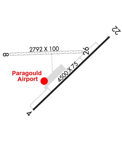
Runway Identifications
Runway Identification: 04/22Length: 4500 ft
Width: 75 ft
Surface: ASPHALT-GOOD CONDITION
Edge lights: Medium IntensityTreatment: NONE
| | Runway: 04 | | Runway: 22 |
| Mag heading: | 45° | Mag heading: | 225° |
| Rwy Slope: | -.10% Down | Rwy Slope: | .10% Up |
| Approach: | | Approach: | |
| Pattern: | Left Traffic | Pattern: | Left Traffic |
| Markings: | NONPRECISION INSTRUMENT | Markings: | NONPRECISION INSTRUMENT |
| Marking Condition: | FAIR | Marking Condition: | FAIR |
| Arresting Dev: | | Arresting Dev: | |
| Lat & Long: | N3603.5 W09030.8 | Lat. & Long.: | N3604.0 W09030.1 |
| Elev: | 289.6 ft. MSL | Elev: | 285.0 ft. MSL |
| TCH: | 18 ft. AGL | TCH: | 59 ft. AGL |
| Visual Glide Path: | 3.00 degrees | Visual Glide Path: | 4.00 degrees |
| Displaced Threshold: | 489 feet | Displaced Threshold: | 148 feet |
| Touchdown Zone: | YES | Touchdown Zone: | YES |
| Touchdown Elev.: | 290.2 feet | Touchdown Elev.: | 289.3 feet |
| Visual Glide Slope: | 2-Light PAPI on LEFT side of Runway | Visual Glide Slope: | 2-Light PAPI on LEFT side of Runway |
| RVR Equipment: | | RVR Equipment: | |
| RVV Equipment: | NO | RVV Equipment: | NO |
| Approach Lights: | | Approach Lights: | |
| REIL: | YES | REIL: | YES |
| Centerline Lights: | NO | Centerline Lights: | NO |
| Touchdown lights: | NO | Touchdown lights: | NO |
| Runway Category: | Runway with a Non-precision Approach having visibility minimums greater than 3/4 mile | Runway Category: | Runway with a Non-precision Approach having visibility minimums greater than 3/4 mile |
| Declared Distances: | | Declared Distances: | |
| Obstructions: | ROAD | Obstructions: | ROAD |
| Marked: | NOT Marked/Lighted | Marked: | NOT Marked/Lighted |
| Clearance slope: | APCH RATIO 23:1 TO DSPLCD THLD. | Clearance slope: | 20:1; APCH SLOPE 46:1 TO DSPLD THLD. |
| Obstruction height: | 28 feet AGL | Obstruction height: | 13 feet AGL |
| Dist. from runway: | 180 feet | Dist. from runway: | 460 feet |
| Centerline offset: | | Centerline offset: | 200 feet left of centerline |
| Comments: | ROAD 180 FT & EXTENDS INTO RY PROTECTION ZONE. | Comments: | OPEN DITCH 55 FT WIDE; 10 FT DEEP 138 FT FM THLD CROSSING. |
Runway Identification: 08/26Length: 2792 ft
Width: 100 ft
Surface: GRASS-FAIR CONDITION
Edge lights: Treatment: NONE
| | Runway: 08 | | Runway: 26 |
| Mag heading: | 88° | Mag heading: | 268° |
| Rwy Slope: | -.14% Down | Rwy Slope: | .14% Up |
| Approach: | | Approach: | |
| Pattern: | Left Traffic | Pattern: | Left Traffic |
| Markings: | NONSTANDARD | Markings: | NONSTANDARD |
| Marking Condition: | GOOD | Marking Condition: | GOOD |
| Arresting Dev: | | Arresting Dev: | |
| Lat & Long: | N3603.9 W09031.0 | Lat. & Long.: | N3603.9 W09030.4 |
| Elev: | 283.0 ft. MSL | Elev: | 279.0 ft. MSL |
| TCH: | | TCH: | |
| Visual Glide Path: | | Visual Glide Path: | |
| Displaced Threshold: | No | Displaced Threshold: | No |
| Touchdown Zone: | YES | Touchdown Zone: | YES |
| Touchdown Elev.: | 283.0 feet | Touchdown Elev.: | 279.0 feet |
| Visual Glide Slope: | | Visual Glide Slope: | |
| RVR Equipment: | | RVR Equipment: | |
| RVV Equipment: | NO | RVV Equipment: | NO |
| Approach Lights: | | Approach Lights: | |
| REIL: | NO | REIL: | NO |
| Centerline Lights: | NO | Centerline Lights: | NO |
| Touchdown lights: | NO | Touchdown lights: | NO |
| Runway Category: | Runway with a Visual Approach | Runway Category: | Runway with a Visual Approach |
| Declared Distances: | | Declared Distances: | |
| Obstructions: | PLINE | Obstructions: | TREES |
| Marked: | NOT Marked/Lighted | Marked: | NOT Marked/Lighted |
| Clearance slope: | 32:1 | Clearance slope: | 43:1 |
| Obstruction height: | 40 feet AGL | Obstruction height: | 40 feet AGL |
| Dist. from runway: | 1300 feet | Dist. from runway: | 1750 feet |
| Centerline offset: | 50 right of centerline | Centerline offset: | |
| Comments: | | Comments: | |