Current Weather/Notams (Metars, TAFs, Notams, NWS Forecast, PIREPS, and nearby weather)
Customs Information Send updates to Support@FltPlan.com
Customs Not Available
Database effective 05/16/2024
Airport Diagram might not be current. Facility Name: PUNTA GORDA City Name: PUNTA GORDA County: CHARLOTTE State abbrev: FL State Name: FLORIDA Ownership: PUBLICLY OWNED Use: OPEN TO THE PUBLIC Owner's Name: CHARLOTTE COUNTY ARPT AUTH Address: 28000 A-1 AIRPORT RD PUNTA GORDA, FL 33982 Owner's Phone: 941-639-1101 Manager's Name: JAMES W PARISH Address: 28000 A-1 AIRPORT RD PUNTA GORDA, FL 33982 Phone: 941-639-1101; 941-639-1101 EXT123. FAA Region: SOUTHERN FAA Field Office: ORL
Runway Identifications Help
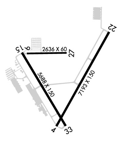
Runway Identification: 04/22 Length: 7193 ftWidth: 150 ftSurface: ASPHALT-FAIR CONDITIONEdge lights: High Intensity Treatment: GROOVEDWeight: PCN 40 /F/B/X/T Runway: 04 Runway: 22 Mag heading: 35° Mag heading: 215° Rwy Slope: .03% Up Rwy Slope: -.03% Down Approach: ILS/DME Approach: Pattern: Left Traffic Pattern: Left Traffic Markings: PRECISION INSTRUMENT Markings: NONPRECISION INSTRUMENT Marking Condition: GOOD Marking Condition: GOOD Arresting Dev: Arresting Dev: Lat & Long: N2654.6 W08159.5 Lat. & Long.: N2655.6 W08158.9 Elev: 23.2 ft. MSL Elev: 25.4 ft. MSL TCH: 50 ft. AGL TCH: 31 ft. AGL Visual Glide Path: 3.00 degrees Visual Glide Path: 3.00 degrees Displaced Threshold: No Displaced Threshold: No Touchdown Zone: YES Touchdown Zone: YES Touchdown Elev.: 23.5 feet Touchdown Elev.: 25.5 feet Visual Glide Slope: 4-Light PAPI on LEFT side of Runway Visual Glide Slope: 4-Light PAPI on LEFT side of Runway RVR Equipment: RVR Equipment: RVV Equipment: NO RVV Equipment: NO Approach Lights: Approach Lights: REIL: YES REIL: YES Centerline Lights: NO Centerline Lights: NO Touchdown lights: NO Touchdown lights: NO Runway Category: Runway with a Non-precision Approach having visibility minimums greater than 3/4 mile Runway Category: Runway with a Non-precision Approach having visibility minimums greater than 3/4 mile Declared Distances: Declared Distances: Obstructions: Obstructions: TREES Marked: Marked: NOT Marked/Lighted Clearance slope: 50:1 Clearance slope: 50:1 Obstruction height: Obstruction height: 31 feet AGL Dist. from runway: Dist. from runway: 1770 feet Centerline offset: Centerline offset: 390 feet right of centerline Comments: Comments:
Runway Identification: 09/27 Length: 2636 ftWidth: 60 ftSurface: ASPHALT-POOR CONDITIONEdge lights: Treatment: NONEWeight: PCN 5 /F/C/Y/T Runway: 09 Runway: 27 Mag heading: 95° Mag heading: 275° Rwy Slope: .11% Up Rwy Slope: -.11% Down Approach: Approach: Pattern: Left Traffic Pattern: Left Traffic Markings: BASIC Markings: BASIC Marking Condition: POOR Marking Condition: POOR Arresting Dev: Arresting Dev: Lat & Long: N2655.4 W08159.9 Lat. & Long.: N2655.4 W08159.4 Elev: 19.1 ft. MSL Elev: 22.1 ft. MSL TCH: TCH: Visual Glide Path: Visual Glide Path: Displaced Threshold: No Displaced Threshold: No Touchdown Zone: YES Touchdown Zone: YES Touchdown Elev.: 22.2 feet Touchdown Elev.: 22.2 feet Visual Glide Slope: Visual Glide Slope: RVR Equipment: RVR Equipment: RVV Equipment: NO RVV Equipment: NO Approach Lights: Approach Lights: REIL: NO REIL: NO Centerline Lights: NO Centerline Lights: NO Touchdown lights: NO Touchdown lights: NO Runway Category: Runway with a Visual Approach Runway Category: Runway with a Visual Approach Declared Distances: TORA:2635' TODA:2635' ASDA:2635' LDA:2635' Declared Distances: TORA:2635' TODA:2635' ASDA:2635' LDA:2635' Obstructions: TREES Obstructions: Marked: NOT Marked/Lighted Marked: Clearance slope: 50:1 Clearance slope: 50:1 Obstruction height: 40 feet AGL Obstruction height: Dist. from runway: 2210 feet Dist. from runway: Centerline offset: 250 left of centerline Centerline offset: Comments: Comments:
Runway Identification: 15/33 Length: 6286 ftWidth: 150 ftSurface: ASPHALTEdge lights: Medium Intensity Treatment: GROOVEDWeight: PCN 37 /F/B/X/T Runway: 15 Runway: 33 Mag heading: 155° Mag heading: 335° Rwy Slope: .07% Up Rwy Slope: -.07% Down Approach: Approach: Pattern: Left Traffic Pattern: Left Traffic Markings: NONPRECISION INSTRUMENT Markings: NONPRECISION INSTRUMENT Marking Condition: GOOD Marking Condition: GOOD Arresting Dev: Arresting Dev: Lat & Long: N2655.4 W08200.0 Lat. & Long.: N2654.5 W08159.4 Elev: 18.5 ft. MSL Elev: 23.0 ft. MSL TCH: 47 ft. AGL TCH: 48 ft. AGL Visual Glide Path: 3.00 degrees Visual Glide Path: 3.00 degrees Displaced Threshold: 271 feet Displaced Threshold: No Touchdown Zone: YES Touchdown Zone: YES Touchdown Elev.: 21.6 feet Touchdown Elev.: 23.5 feet Visual Glide Slope: 4-Light PAPI on LEFT side of Runway Visual Glide Slope: 4-Light PAPI on LEFT side of Runway RVR Equipment: RVR Equipment: RVV Equipment: NO RVV Equipment: NO Approach Lights: Approach Lights: REIL: YES REIL: YES Centerline Lights: NO Centerline Lights: NO Touchdown lights: NO Touchdown lights: NO Runway Category: Runway with a Non-precision Approach having visibility minimums greater than 3/4 mile Runway Category: Runway with a Non-precision Approach having visibility minimums greater than 3/4 mile Declared Distances: TORA:6286' TODA:6286' ASDA:6286' LDA:6015' Declared Distances: TORA:6166' TODA:6166' ASDA:6015' LDA:6015' Obstructions: ROAD Obstructions: TREES Marked: NOT Marked/Lighted Marked: NOT Marked/Lighted Clearance slope: 17:1; RWY 15 APCH SLP 48:1 TO DTHR. Clearance slope: 40:1 Obstruction height: 15 feet AGL Obstruction height: 54 feet AGL Dist. from runway: 460 feet Dist. from runway: 2375 feet Centerline offset: 500 right of centerline Centerline offset: 60 feet right of centerline Comments: Comments: