Current Weather/Notams (Metars, TAFs, Notams, NWS Forecast, PIREPS, and nearby weather)
Customs Information Send updates to Support@FltPlan.com
Customs Not Available
Database effective 05/16/2024
Airport Diagram might not be current.
|
| Facility Name: | PLEASANTON MUNI |
| City Name: | PLEASANTON |
| County: | ATASCOSA |
| State abbrev: | TX |
| State Name: | TEXAS |
| | |
| Ownership: | PUBLICLY OWNED |
| Use: | OPEN TO THE PUBLIC |
| Owner's Name: | CITY OF PLEASANTON |
| Address: | BOX 209 |
| | PLEASANTON, TX 78064 |
| Owner's Phone: | 830-569-3867 |
| | |
| Manager's Name: | JOHN ROBERTS; ASST UTILITIES SUPT. |
| Address: | PO BOX 209 |
| | PLEASANTON, TX 78064 |
| Phone: | (830) 569-3155; EXT 800 |
| | |
| FAA Region: | SOUTHWEST |
| FAA Field Office: | TEX |
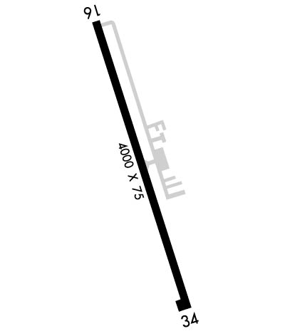
Runway Identifications
Runway Identification: 16/34Length: 4000 ft
Width: 75 ft
Surface: ASPHALT-GOOD CONDITION
Edge lights: Medium IntensityTreatment: NONE
| | Runway: 16 | | Runway: 34 |
| Mag heading: | 157° | Mag heading: | 337° |
| Rwy Slope: | -.75% Down | Rwy Slope: | .75% Up |
| Approach: | | Approach: | |
| Pattern: | Left Traffic | Pattern: | Left Traffic |
| Markings: | NONPRECISION INSTRUMENT | Markings: | NONPRECISION INSTRUMENT |
| Marking Condition: | GOOD | Marking Condition: | GOOD |
| Arresting Dev: | | Arresting Dev: | |
| Lat & Long: | N2857.6 W09831.3 | Lat. & Long.: | N2856.9 W09831.1 |
| Elev: | 430.3 ft. MSL | Elev: | 400.2 ft. MSL |
| TCH: | 25 ft. AGL | TCH: | 35 ft. AGL |
| Visual Glide Path: | 4.00 degrees | Visual Glide Path: | 3.00 degrees |
| Displaced Threshold: | 405 feet | Displaced Threshold: | No |
| Touchdown Zone: | YES | Touchdown Zone: | YES |
| Touchdown Elev.: | 428.3 feet | Touchdown Elev.: | 419.9 feet |
| Visual Glide Slope: | 2-Light PAPI on LEFT side of Runway | Visual Glide Slope: | 2-Light PAPI on LEFT side of Runway |
| RVR Equipment: | | RVR Equipment: | |
| RVV Equipment: | NO | RVV Equipment: | NO |
| Approach Lights: | | Approach Lights: | |
| REIL: | NO | REIL: | NO |
| Centerline Lights: | NO | Centerline Lights: | NO |
| Touchdown lights: | NO | Touchdown lights: | NO |
| Runway Category: | Runway with a Visual Approach | Runway Category: | Runway with a Non-precision Approach |
| Declared Distances: | | Declared Distances: | |
| Obstructions: | ROAD | Obstructions: | FENCE |
| Marked: | NOT Marked/Lighted | Marked: | NOT Marked/Lighted |
| Clearance slope: | APCH SLOPE 0:1 AT DSPLCD THR OVR 8 FT FENCE AT DSPLCD THR 190 FT RIGHT. | Clearance slope: | |
| Obstruction height: | 16 feet AGL | Obstruction height: | 8 feet AGL |
| Dist. from runway: | 201 feet | Dist. from runway: | 201 feet |
| Centerline offset: | 212 right of centerline | Centerline offset: | 90 feet right of centerline |
| Comments: | 8 FT FENCE, 36 FT DSTC, 220 FT L. | Comments: | 8 FT FENCE, 0-199 FT DSTC, R/L. |

