Current Weather/Notams (Metars, TAFs, Notams, NWS Forecast, PIREPS, and nearby weather)
Customs Information Send updates to Support@FltPlan.com
Customs Not Available
Database effective 05/16/2024
Airport Diagram might not be current.
|
| Facility Name: | PECOS MUNI |
| City Name: | PECOS |
| County: | REEVES |
| State abbrev: | TX |
| State Name: | TEXAS |
| | |
| Ownership: | PUBLICLY OWNED |
| Use: | OPEN TO THE PUBLIC |
| Owner's Name: | CITY OF PECOS |
| Address: | PO BOX 929 |
| | PECOS, TX 79772 |
| Owner's Phone: | 432-445-2421 |
| | |
| Manager's Name: | COLEY MEANS |
| Address: | 3110 MANAHAN STREET |
| | PECOS, TX 79772 |
| Phone: | (512) 422-6396 |
| | |
| FAA Region: | SOUTHWEST |
| FAA Field Office: | TEX |
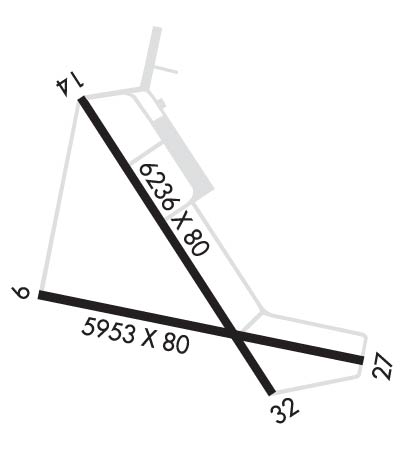
Runway Identifications
Runway Identification: 09/27Length: 5953 ft
Width: 80 ft
Surface: ASPHALT-GOOD CONDITION
Edge lights: Medium IntensityTreatment: NONE
| | Runway: 09 | | Runway: 27 |
| Mag heading: | 92° | Mag heading: | 272° |
| Rwy Slope: | -.25% Down | Rwy Slope: | .25% Up |
| Approach: | | Approach: | |
| Pattern: | Left Traffic | Pattern: | Left Traffic |
| Markings: | NONPRECISION INSTRUMENT | Markings: | NONPRECISION INSTRUMENT |
| Marking Condition: | GOOD | Marking Condition: | GOOD |
| Arresting Dev: | | Arresting Dev: | |
| Lat & Long: | N3122.9 W10331.2 | Lat. & Long.: | N3122.7 W10330.0 |
| Elev: | 2613.0 ft. MSL | Elev: | 2597.9 ft. MSL |
| TCH: | | TCH: | |
| Visual Glide Path: | | Visual Glide Path: | |
| Displaced Threshold: | No | Displaced Threshold: | No |
| Touchdown Zone: | YES | Touchdown Zone: | YES |
| Touchdown Elev.: | 2613.1 feet | Touchdown Elev.: | 2603.0 feet |
| Visual Glide Slope: | | Visual Glide Slope: | |
| RVR Equipment: | | RVR Equipment: | |
| RVV Equipment: | NO | RVV Equipment: | NO |
| Approach Lights: | | Approach Lights: | |
| REIL: | NO | REIL: | NO |
| Centerline Lights: | NO | Centerline Lights: | NO |
| Touchdown lights: | NO | Touchdown lights: | NO |
| Runway Category: | Runway with a Visual Approach | Runway Category: | Runway with a Visual Approach |
| Declared Distances: | | Declared Distances: | |
| Obstructions: | | Obstructions: | PLINE |
| Marked: | | Marked: | MARKED |
| Clearance slope: | 20:1 | Clearance slope: | 40:1 |
| Obstruction height: | | Obstruction height: | 45 feet AGL |
| Dist. from runway: | | Dist. from runway: | 2020 feet |
| Centerline offset: | | Centerline offset: | |
| Comments: | | Comments: | |
Runway Identification: 14/32Length: 6236 ft
Width: 80 ft
Surface: ASPHALT-GOOD CONDITION
Edge lights: Medium IntensityTreatment: NONE
| | Runway: 14 | | Runway: 32 |
| Mag heading: | 137° | Mag heading: | 317° |
| Rwy Slope: | -.12% Down | Rwy Slope: | .12% Up |
| Approach: | | Approach: | |
| Pattern: | Left Traffic | Pattern: | Left Traffic |
| Markings: | NONPRECISION INSTRUMENT | Markings: | NONPRECISION INSTRUMENT |
| Marking Condition: | GOOD | Marking Condition: | GOOD |
| Arresting Dev: | | Arresting Dev: | |
| Lat & Long: | N3123.5 W10331.0 | Lat. & Long.: | N3122.6 W10330.4 |
| Elev: | 2608.1 ft. MSL | Elev: | 2600.9 ft. MSL |
| TCH: | 40 ft. AGL | TCH: | 40 ft. AGL |
| Visual Glide Path: | 3.00 degrees | Visual Glide Path: | 3.00 degrees |
| Displaced Threshold: | No | Displaced Threshold: | No |
| Touchdown Zone: | YES | Touchdown Zone: | YES |
| Touchdown Elev.: | 2608.2 feet | Touchdown Elev.: | 2605.1 feet |
| Visual Glide Slope: | 2-Light PAPI on LEFT side of Runway; PAPI OTS | Visual Glide Slope: | 2-Light PAPI on LEFT side of Runway |
| RVR Equipment: | | RVR Equipment: | |
| RVV Equipment: | NO | RVV Equipment: | NO |
| Approach Lights: | | Approach Lights: | |
| REIL: | NO | REIL: | NO |
| Centerline Lights: | NO | Centerline Lights: | NO |
| Touchdown lights: | NO | Touchdown lights: | NO |
| Runway Category: | D | Runway Category: | D |
| Declared Distances: | | Declared Distances: | |
| Obstructions: | SIGN | Obstructions: | |
| Marked: | NOT Marked/Lighted | Marked: | |
| Clearance slope: | 30:1 | Clearance slope: | 50:1 |
| Obstruction height: | 75 feet AGL | Obstruction height: | |
| Dist. from runway: | 2514 feet | Dist. from runway: | |
| Centerline offset: | 395 left of centerline | Centerline offset: | |
| Comments: | | Comments: | |

