Click here for more info on on SMS!

KPEA

PELLA MUNI
PELLA
IA
Time Zone: Central
Lat: N 4124.1
Long: W 09256.8
Elev: 885
Var: -02
Longest Runway: 5403
AWOS: 118.87
CTAF: 122.8

FBO & Flight Services info for KPEA

FBOs: Update your Fuel Prices

  click here  
Classic Aviation, Inc. has been the fixed based operator of the Pella Municipal Airport since 1988. We are a professional aviation services company dedicated to providing quality service to our customers.
Ph: 641-628-9393 Fax: 641-621-9515 Freq: 122.8WebsiteE-Mail
                                         
Service
Jet
100LL
SAF
MoGas
Fuel Avail: PRIST PREMIXED. M-SAT: 7A-DUSK, SUN: 12P-5P, SURCHRG AFTR HRS
Full5.756.40    Last Update: 04/08/2024 09:48

Self        
Misc. Info: Address: 501 W. 15TH STREET,   PELLA, IA 50219-7891

AWOSPh: 641-628-3459
-
Freq: 118.87  
If you are an FBO, call 1-203-262-1700 to update your info or email: FltPlan.Advertising@garmin.com
Advertise your FBO on FltPlan.com

Runway & Approach Info for KPEA
Rwy
Length
Land Dist**
Approach*
  Rwy
Length
Land Dist**
Approach*
16
5403x75  5203'          
 
  
34
  5403x75  5202'          
 
 * only ILS, LOC, LDA, and SDF approaches to a specific runway are shown
** For any Declared Landing Distance Available, please see A/FD or Approach plates
Runway Weight Capability (lbs.) Help
Runway IDSingle WheelDouble WheelDouble Tandem WheelDual Double Wheel
16/3430,00040,000N/AN/A
These numbers are Advisory and are not limits.   The Airport Manager should have more accurate Weight Limits
Approach Charts
Approaches    
Current Weather/Notams
Customs Information Send updates to Support@FltPlan.com
Customs Not Available
Database effective 04/18/2024
Airport Diagram of KPEA
Airport Diagram might not be current.

Facility Name: PELLA MUNI
City Name: PELLA
County: MARION
State abbrev: IA
State Name: IOWA
   
Ownership: PUBLICLY OWNED
Use: OPEN TO THE PUBLIC
Owner's Name: CITY OF PELLA
Address: 717 MAIN
 PELLA, IA 50219
Owner's Phone: 641-628-4173
  
Manager's Name: SHANE VANDEVOORT
Address: 501 WEST 15TH STREET; EMAIL ADDRESS: SHANE@FLYCLASSICAVIATION.COM (ALL LOWER CASE)
 PELLA, IA 50219
Phone: 641-628-9393; CELL PHONE 641-780-0244
   
FAA Region: CENTRAL
FAA Field Office: NONE


Sunrise / Sunset times for PELLA MUNI

DateSunriseSunset
04/19/24 Friday6:2519:57
04/20/24 Saturday6:2319:58
04/21/24 Sunday6:2219:59
04/22/24 Monday6:2020:01
04/23/24 Tuesday6:1920:02
04/24/24 Wednesday6:1820:03
04/25/24 Thursday6:1620:04
04/26/24 Friday6:1520:05
04/27/24 Saturday6:1320:06
04/28/24 Sunday6:1220:07
04/29/24 Monday6:1120:08
04/30/24 Tuesday6:0920:09
05/01/24 Wednesday6:0820:10
05/02/24 Thursday6:0720:11

Airport Facilities

Airport Attendance ScheduleMON-SAT 0700-DUSK, SUN 0900-1700; AFTER HRS CALL 641-780-0244.
Airport Status OPERATIONAL (This Status can change at any time - please check NOTAMS)
Airport Lighting ScheduleMIRL RWY 16/34 PRESET LOW INTST; TO INCREASE INTST AND ACTVT PAPI RWY 16 & 34; REIL RWYS 16 & 34 - CTAF.
Airport Storage AvailableTie Downs, Hanger
Extra Services AvailableFlight Instruction, Aircraft Rental
Wind IndicatorYES - (lighted)
Control TowerNO
CTAF Frequency122.800
Unicom Frequency122.800
Rotating Beacon ColorWG
Segmented CircleNO
Landing FeeNO

Airport Inspection Data

Airport InspectedSTATE - performed by STATE AERONAUTICAL PERSONNEL
Inspection Date05/23/2022

Airport Services

Type of Fuel AvailableGrade 100LL, JET A (freeze point -40C)
Airframe Repair ServiceMAJOR
Power Plant Repair ServiceMAJOR

Geographic Data

LatitudeN4124.1
LongitudeW09256.8 (ESTIMATED)
Arpt Elevation884ft (SURVEYED)
Magnetic Variation02E
1 miles Wof PELLA
Traffic Pattern Altitude816; ONLY APPLIES TO NON-TURBINE ACFT.
Sectional ChartCHICAGO

Aircraft Data

Operations (Reported)YearlyAvg. Daily
General Aviation Transient 32679
General Aviation Local 898325
Air Taxi 00
Commerical 00
Commuter 00
Military 00
Aircraft based on Field
General Aviation Singles 25
General Aviation Multi 2
Jet Aircraft 3
General Aviation Helicopters 0
Military Aircraft 0
Gliders 0
Ultralights 0

FAA Services

FSS on field NO
FSS tie-in FORT DODGE
FSS Phone 1-800-WX-BRIEF
Who issues Notams PEA
Notam D service at airport YES
ARTCC Name CHICAGO

Federal Status

Airport Certification
Aircraft Rescue & Firefighting IndexNone
Airport of EntryNo
Custom Landing RightsNo
Joint Civil/MilitaryNo
Military Landing rightsNo

Federal Agreements

NATIONAL PLAN OF INTEGRATED AIRPORT SYSTEMS (NPIAS)

Remarks

FOR CD CTC DES MOINES ATCT AT 515-974-8016.
Airport Communications & Frequencies:
CTAF Frequency:
122.800
Unicom Frequency:
122.800
DES MOINES Primary Approach Frequencies:  
123.9
307.15
DES MOINES Primary Departure Frequencies:  
123.9
307.15
Runway Identifications
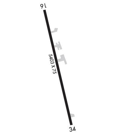
Runway Identification: 16/34
Length: 5403 ft
Width: 75 ft
Surface: CONCRETE-FAIR CONDITION
Edge lights: Medium Intensity

Treatment: NONE
Weight: PCN 8 /R/D/W/T

 Runway: 16   Runway: 34
Mag heading: 165°Mag heading: 345°
Rwy Slope: -.28% DownRwy Slope: .28% Up
Approach: Approach:
Pattern: Left TrafficPattern: Left Traffic
Markings: NONPRECISION INSTRUMENTMarkings: NONPRECISION INSTRUMENT
Marking Condition: FAIRMarking Condition: FAIR
Arresting Dev: Arresting Dev:
Lat & Long: N4124.5  W09256.9Lat. & Long.: N4123.6  W09256.6
Elev: 884.8 ft. MSLElev: 869.6 ft. MSL
TCH: 26 ft. AGLTCH: 46 ft. AGL
Visual Glide Path: 3.30 degreesVisual Glide Path: 3.00 degrees
Displaced Threshold: 200 feetDisplaced Threshold: 201 feet
Touchdown Zone: YESTouchdown Zone: YES
Touchdown Elev.: 884.6 feetTouchdown Elev.: 879.2 feet
Visual Glide Slope: 2-Light PAPI on LEFT side of RunwayVisual Glide Slope: 2-Light PAPI on LEFT side of Runway
RVR Equipment: RVR Equipment:
RVV Equipment: NORVV Equipment: NO
Approach Lights: Approach Lights:
REIL: YESREIL: YES
Centerline Lights: NOCenterline Lights: NO
Touchdown lights: NOTouchdown lights: NO
Runway Category: Runway with a Non-precision Approach having visibility minimums greater than 3/4 mileRunway Category: Runway with a Non-precision Approach having visibility minimums greater than 3/4 mile
Declared Distances: TORA:5400' TODA:5400' ASDA:5200' LDA:5000'Declared Distances: TORA:5400' TODA:5400' ASDA:5200' LDA:5000'
Obstructions: TREEObstructions: TREES
Marked: NOT Marked/LightedMarked: NOT Marked/Lighted
Clearance slope: 10:1; RWY 16 APCH SLP TO DTHR 22:1.Clearance slope: 8:1; RWY 34 APCH SLP TO DTHR 21:1.
Obstruction height: 32 feet AGLObstruction height: 31 feet AGL
Dist. from runway: 527 feetDist. from runway: 474 feet
Centerline offset: 191 left of centerlineCenterline offset: 188 feet left of centerline
Comments: Comments:
C:12/P: