Click here for more info on on SMS!

KPDX

Whisper PlateWhisper Track
PORTLAND INTL
PORTLAND
OR
Time Zone: Pacific
Lat: N 4535.3
Long: W 12235.8
Elev: 31
Var: -16
Longest Runway: 11000
Clr Del: 120.12
Dept. ATIS: 128.35
Arr. ATIS: 128.35
Ground: 121.9/132.27
Tower: 118.7/ 123.77

FBO & Flight Services info for KPDX

FBOs: Update your Fuel Prices
Atlantic Aviation is your premier aviation service provider with more than 100 locations in North America, including Hawaii and the Caribbean. We provide standard ground services you'd expect, with a detailed focus on ensuring an unforgettable customer experience.
Ph: 503-331-4220 Fax: 503-331-4273 Freq: 122.95WebsiteE-Mail
Service
Jet
100LL
SAF
MoGas
Full7.368.54    Last Update: 04/25/2024 13:10:33

Self        
Misc. Info: Address: 8089 NE AIRPORT WAY   PORTLAND, OR 97218

ASOSPh: 503-493-7687
-
-
 
If you are an FBO, call 1-203-262-1700 to update your info or email: FltPlan.Advertising@garmin.com
Advertise your FBO on FltPlan.com

Runway & Approach Info for KPDX
Rwy
Length
Land Dist**
Approach*
  Rwy
Length
Land Dist**
Approach*
03
6000x150  6000'          
 
  
21
  6000x150  6000'          
LOC/DME
 108.90 - 209°  
10L
9825x150  8535'          
ILS/DME
 111.30 - 103°  
  
28R
  9825x150  9290'          
ILS/DME
 111.30 - 283°  
10R
11000x150  11000'          
ILS/DME
 110.50 - 103°  
  
28L
  11000x150  11000'          
ILS/DME
 110.50 - 283°  
 * only ILS, LOC, LDA, and SDF approaches to a specific runway are shown
** For any Declared Landing Distance Available, please see A/FD or Approach plates
Runway Weight Capability (lbs.) Help
Runway IDSingle WheelDouble WheelDouble Tandem WheelDual Double Wheel
03/21120,000250,000380,000N/A
10L/28R200,000200,000400,000N/A
10R/28L200,000200,000360,000N/A
These numbers are Advisory and are not limits.   The Airport Manager should have more accurate Weight Limits
Approach Charts
Approaches    
Current Weather/Notams
Customs Information Send updates to Support@FltPlan.com
Phone 503-326-3409
Fax 503-326-7040

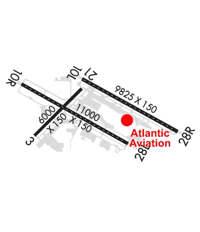
Comments Available Monday-Saturday 8:00-5:00 PM Pacific time. Call 1 hour prior to arrival. Call prior to 5:00 PM Friday preceding holiday/weekend to schedule service. *Facility located on FBO's Ramp. *Maximum passengers per flight: 15
Database effective 05/16/2024
Airport Diagram of KPDX
Airport Diagram might not be current.

Facility Name: PORTLAND INTL
City Name: PORTLAND
County: MULTNOMAH
State abbrev: OR
State Name: OREGON
   
Ownership: PUBLICLY OWNED
Use: OPEN TO THE PUBLIC
Owner's Name: THE PORT OF PORTLAND
Address: BOX 3529
 PORTLAND, OR 97208
Owner's Phone: 503-415-6000
  
Manager's Name: STEPHEN NAGY; ARPT OPS GENERAL MGR
Address: 7200 NE AIRPORT WAY
 PORTLAND, OR 97218
Phone: 503-415-6195
   
FAA Region: NORTHWEST MOUNTAIN
FAA Field Office: SEA


Sunrise / Sunset times for PORTLAND INTL

DateSunriseSunset
04/24/24 Wednesday6:0820:10
04/25/24 Thursday6:0620:11
04/26/24 Friday6:0520:12
04/27/24 Saturday6:0320:13
04/28/24 Sunday6:0220:15
04/29/24 Monday6:0020:16
04/30/24 Tuesday5:5820:17
05/01/24 Wednesday5:5720:19
05/02/24 Thursday5:5520:20
05/03/24 Friday5:5420:21
05/04/24 Saturday5:5320:22
05/05/24 Sunday5:5120:24
05/06/24 Monday5:5020:25
05/07/24 Tuesday5:4820:26

Airport Facilities

Airport Attendance ScheduleCONTINUOUS
Airport Status OPERATIONAL (This Status can change at any time - please check NOTAMS)
Airport Lighting ScheduleSS-SR
Airport Storage AvailableTie Downs, Hanger
Extra Services AvailableAir Freight, Air Ambulance, Avionics, Cargo Handling, Charter, Flight Instruction, Aircraft Rental, Aircraft Sales
Wind IndicatorYES - (lighted)
Control TowerYES
CTAF Frequency
Unicom Frequency122.950
Rotating Beacon ColorWG
Segmented CircleNO
Landing FeeYES; COMMERCIAL ACFT & OPERATORS OF ACFT WITH AN FAA CERTIFIED MAX GROSS LANDING WEIGHT THAT EXCEEDS 10000 LBS ARE REQUIRED TO PAY A LANDING FEE.

Airport Inspection Data

Airport InspectedFEDERAL - performed by FAA AIRPORTS FIELD PERSONNEL
Inspection Date09/10/2021

Airport Services

Type of Fuel AvailableGrade 100LL, JET A (freeze point -40C)
Airframe Repair ServiceMAJOR
Power Plant Repair ServiceMAJOR

Geographic Data

LatitudeN4535.3
LongitudeW12235.8 (ESTIMATED)
Arpt Elevation30ft (SURVEYED)
Magnetic Variation16E
4 miles NEof PORTLAND
Traffic Pattern Altitude
Sectional ChartSEATTLE

Aircraft Data

Operations (Reported)YearlyAvg. Daily
General Aviation Transient 852023
General Aviation Local 23656
Air Taxi 1692946
Commerical 137887378
Commuter 00
Military 23316
Aircraft based on Field
General Aviation Singles 2
General Aviation Multi 44
Jet Aircraft 22
General Aviation Helicopters 1
Military Aircraft 21
Gliders 0
Ultralights 0

FAA Services

FSS on field NO
FSS tie-in MC MINNVILLE
FSS Phone 1-800-WX-BRIEF
Who issues Notams PDX
Notam D service at airport YES
ARTCC Name SEATTLE

Federal Status

Airport CertificationAIRPORT RECEIVING SCHEDULED AIR CARRIER SERVICE FROM CARRIERS CERTIFICATED BY THE CIVIL AERONAUTICS BOARD
Aircraft Rescue & Firefighting IndexAIRPORT HAS A CERTIFICATE UNDER CFR PART 139
Airport of EntryNo
Custom Landing RightsYES
Joint Civil/MilitaryNo
Military Landing rightsYES

Federal Agreements

NATIONAL PLAN OF INTEGRATED AIRPORT SYSTEMS (NPIAS)
GRANT AGREEMENTS UNDER FAAP/ADAP/AIP
SURPLUS PROPERTY AGREEMENT UNDER PUBLIC LAW 289
ASSURANCES PURSUANT TO TITLE VI, CIVIL RIGHTS ACT OF 1964

Remarks

UNCONTROLLED TFC AT PEARSON FIELD VANCOUVER WA 3 NM W OF RY 10L THLD ON EXTDD CNTRLN.
(E94) WSFO/WSO/FW/RFC.
AREA OF TWY T BTN M & E3 NOT VSB FM TWR.
ACFT AUTHORIZED TO UTILIZE THE NORTHWEST RAMP WILL BE TOWED TO/FROM THIS RAMP.
AT THE WEST END ARM/DEARM AREA ON TWY C NO ACFT OF ANY TYPE MAY TAXI PAST THE ARM/DEARM AREA WHILE IT IS BEING USED.
ARPT CLSD TO NON-POWERED ACFT EXCP IN EMERG.
BEARING STRENGTH: RWY 03-21 ST 175, RY 10L-28R ST175, RY 10R-28L ST175.
JASU - 4(A/M32A-86) (MC-11) 1(MA-1A).
FUEL - A (AIR BP - ATLANTIC AVIATION SVCS. C503-331-4220) J8(MIL) (NC-100LL, A)
FLUID - LHOXRB.
OIL - O-128-133-148(MIL).
MISC: FLT NOTIFICATION SVC, ADCUS, AVBL.
ANG : PPR/OFFL BUS ONLY. BASE OPS OPR 1500-2300Z++ MON-FRI EXC HOL.; DSN 638-4390, C503-335-4390. CTC BASE OPS 15 MIN PRIOR TO LDG AND AFTER DEP ON 281.2. TRAN QUARTERS NOT AVBL. CAUTION: OBST LIGHTING IS NOT NVD COMPATIBLE. NVD NOT AUTHORIZED WHILE AIRBORNE IN VCNTY OF AFLD.
TWY V CLSD TO ACFT WITH WINGSPAN GREATER THAN 168 FT. ACFT WITH WINGSPAN GREATER THAN 118 FT PROHIBITED FM TURNING WB ONTO TWY A FM TWY V UNLESS UNDER TOW.
ANG: SEE FLIP AP/1 FOR SUPPLEMENTARY ARPT INFO. HAZARDOUS BIRD COND EXIST. PHASE 1 MAY-OCT, PHASE II NOV-APR. CURRENT BIRD WATCH CONDITIONS ARE NOT REPORTED ON ATIS.
TWY W CLSD TO ACFT WITH WINGSPAN GTR THAN 118 FT UNLESS UNDER TOW.
TWY T BTN EXITS B5 & B6 CLSD TO ACFT WITH WINGSPAN GTR THAN 118 FT.
NSTD YELLOW PRK SPOT DESIGNATORS AND EQPT TOOL BOX LCTN PAINTED ON RAMP. PLEASE CTC BASE OPS OR REQ FOLLOW ME IF NOT FAMILIAR WITH PANGB PRK PROCEDURES.
TWY C3 CLSD TO ACFT WITH WINGSPAN EQUAL TO OR GTR THAN 79 FT.
PDX HAS FAC CONSTRAINTS THAT LMT ITS ABILITY TO ACCOMMODATE DIVD FLTS & MNTN THE ARPT SAFE OPN DUR IREG OPS. ACFT OPRS SHUD CTC THE ARPT DUTY MGR AT (503) 460-4236 TO COORD DIVD FLTS EXC IN THE CASE OF A DECLARED IN-FLT EMERG.
ACFT WITH WINGSPAN GREATER THAN 118 FEET ARE PROHIBITED FROM TURNING EASTBOUND ON TWY C FROM SOUTHWESTBOUND ON TWY F UNLESS UNDER TOW.
TWY A3 BTN TWY A & THE GA RAMP CLSD TO ACFT WITH WINGSPAN GTR THAN 135 FEET UNLESS UNDER TOW.
TWY C BTN TWY C6 AND TWY C8 CLSD TO ACFT WITH WINGSPAN GTR THAN 200 FT.
ASSC IN USE. OPERATE TRANSPONDERS WITH ALTITUDE REPORTING MODE AND ADS-B (IF EQUIPPED) ENABLED ON ALL AIRPORT SURFACES.
TWY K BTN TWY A5 & TWY V CLSD TO ACFT WINGSPAN MORE THAN 168 FT.
MIGRATORY & WINTERING FLOCKS OF LRG WATERFOWL ON & INVOF APRT. HEAVY SEAGULL ACTIVITY SEP THRU APR; EXPECT HIGH NMBR OF BIRDS YEAR AROUND; CK LCL ADVISORIES.
TWY K BTN TWY V & TWY A4 CLSD TO ACFT WINGSPAN MORE THAN 118 FT.
MILITARY: ANG: OREGON ANG E RAMP SUN SHADE OBST LGTS O/S.
NOISE ABATEMENT PROCEDURES IN EFFECT; CALL NOISE OFFICE AT 503-460-4100. RY 28L ARRIVALS ARE NOISE SENSITIVE, EXPECT APCH TO 28R WITH TRANSITION TO 28L.
180 DEGREE TURNS BY ACFT WEIGHING IN EXCESS OF 12500 LBS PROHIBITED ON RY 10L/28R, RY 03/21 AND ALL TWYS.
RWY 03/2 1 RY 21 CLSD TO HEIGHT GROUP IV ACFT WITH COCKPIT TO WHEEL HEIGHT GREATER THAN 22 FT.
Airport Communications & Frequencies:
ATIS Frequencies:   Hours(local) of Operation: CONTINUOUS
128.35
269.9
PORTLAND Tower Frequencies:   Hours(local) of operation: CONTINUOUS   
118.7 ;RWY 10L/28R
123.775 ;RWY 03/21, 10R/28L
251.125 ;RWY 03/21, 10R/28L
257.8 ;RWY 10L/28R
PORTLAND Ground Frequencies:
121.9
132.275
348.6
Clearance Delivery Frequencies:
120.125
318.1
Emergency Frequencies:
121.5
243.0
Unicom Frequency:
122.950
Remarks
  • OPERATIONS CALL- SAVE -OPERATED BY AFR, 24 HRS
  • PDX MONITORS 121.5 FOR MCMINNVILLE (MMV).
  • PORTLAND Primary Approach Frequencies:  
    118.1 100-279, HIGH
    124.35 280-099
    126.9 FINAL
    284.6 100-279, HIGH
    299.2 280-099
    Part-time Approach Frequencies:  
    294.7
    PORTLAND Primary Departure Frequencies:  
    118.1 100-279, HIGH
    124.35 280-099
    284.6 100-279, HIGH
    299.2 280-099
    Part-time Departure Frequencies:  
    127.85
    290.3
    Class C Frequencies:
    118.1 100-279, HIGH
    124.35 280-099
    284.6 100-279, HIGH
    299.2 280-099
    Runway Identifications
    Runway Identification: 03/21
    Length: 6000 ft
    Width: 150 ft
    Surface: ASPHALT
    Edge lights: Medium Intensity

    Treatment: GROOVED
    Weight: PCN 82 /F/D/X/T

     Runway: 03   Runway: 21
    Mag heading: 29°Mag heading: 209°
    Rwy Slope: .07% UpRwy Slope: -.07% Down
    Approach: Approach: LOC/DME
    Pattern: Left TrafficPattern: Left Traffic
    Markings: NONPRECISION INSTRUMENTMarkings: NONPRECISION INSTRUMENT
    Marking Condition: GOODMarking Condition: GOOD
    Arresting Dev: Arresting Dev:
    Lat & Long: N4534.9  W12237.0Lat. & Long.: N4535.6  W12236.0
    Elev: 22.2 ft. MSLElev: 26.4 ft. MSL
    TCH: 60 ft. AGLTCH: 32 ft. AGL
    Visual Glide Path: 3.30 degreesVisual Glide Path: 3.60 degrees
    Displaced Threshold: NoDisplaced Threshold: No
    Touchdown Zone: YESTouchdown Zone: YES
    Touchdown Elev.: 22.9 feetTouchdown Elev.: 26.4 feet
    Visual Glide Slope: 4-Light PAPI on LEFT side of Runway; PDX RWY 03 PAPI UNUSABLE BYND 4 DEG LEFT AND RIGHT OF RCL AND BEYOND 5 NM UNUSABLEVisual Glide Slope: 4-Light PAPI on RIGHT side of Runway
    RVR Equipment: RVR Equipment:
    RVV Equipment: NORVV Equipment: NO
    Approach Lights: Approach Lights:
    REIL: YESREIL: YES
    Centerline Lights: NOCenterline Lights: NO
    Touchdown lights: NOTouchdown lights: NO
    Runway Category: Runway with a Visual ApproachRunway Category: Runway with a Non-precision Approach having visibility minimums greater than 3/4 mile
    Declared Distances: TORA:6000' TODA:6000' ASDA:6000' LDA:6000'Declared Distances: TORA:6000' TODA:6000' ASDA:6000' LDA:6000'
    Obstructions: Obstructions: ROAD
    Marked: Marked: NOT Marked/Lighted
    Clearance slope: 34:1Clearance slope: 14:1
    Obstruction height: Obstruction height: 19 feet AGL
    Dist. from runway: Dist. from runway: 475 feet
    Centerline offset: Centerline offset:
    Comments: Comments:
    Runway Identification: 10L/28R
    Length: 9825 ft
    Width: 150 ft
    Surface: ASPHALT
    Edge lights: High Intensity

    Treatment: GROOVED
    Weight: PCN 133/F/D/W/T

     Runway: 10L   Runway: 28R
    Mag heading: 103°Mag heading: 283°
    Rwy Slope: .01% UpRwy Slope: -.01% Down
    Approach: ILS/DMEApproach: ILS/DME
    Pattern: Left TrafficPattern: Right Traffic
    Markings: PRECISION INSTRUMENTMarkings: PRECISION INSTRUMENT
    Marking Condition: GOODMarking Condition: GOOD
    Arresting Dev: Arresting Dev:
    Lat & Long: N4535.8  W12236.0Lat. & Long.: N4535.0  W12234.0
    Elev: 29.5 ft. MSLElev: 30.8 ft. MSL
    TCH: 51 ft. AGLTCH: 70 ft. AGL
    Visual Glide Path: 3.00 degreesVisual Glide Path: 3.00 degrees
    Displaced Threshold: 1290 feetDisplaced Threshold: 535 feet
    Touchdown Zone: YESTouchdown Zone: YES
    Touchdown Elev.: 30.2 feetTouchdown Elev.: 30.8 feet
    Visual Glide Slope: 4-Light PAPI on LEFT side of RunwayVisual Glide Slope: 4-Light PAPI on RIGHT side of Runway
    RVR Equipment: TOUCHDOWN-MIDFIELD-ROLLOUTRVR Equipment: TOUCHDOWN-MIDFIELD-ROLLOUT
    RVV Equipment: NORVV Equipment: NO
    Approach Lights: MALSR - 1,400 foot medium intensity approach lighting system with runway alignment indicator lightsApproach Lights: MALSR - 1,400 foot medium intensity approach lighting system with runway alignment indicator lights
    REIL: NOREIL: NO
    Centerline Lights: YESCenterline Lights: YES
    Touchdown lights: NOTouchdown lights: NO
    Runway Category: Precision Instrument RunwayRunway Category: Precision Instrument Runway
    Declared Distances: TORA:9825' TODA:9825' ASDA:9825' LDA:8535'Declared Distances: TORA:9825' TODA:9825' ASDA:9825' LDA:9290'
    Obstructions: Obstructions: ROAD; RWY 28R PERIMETER ROAD AT 200 FT FM RWY THLD AND 408' RIGHT FM RWY EXTNDD CNTRLN.
    Marked: Marked: NOT Marked/Lighted
    Clearance slope: 50:1Clearance slope:
    Obstruction height: Obstruction height: 32 feet AGL
    Dist. from runway: Dist. from runway: 200 feet
    Centerline offset: Centerline offset: 408 feet right of centerline
    Comments: Comments: RWY 28R 60' LEVEE ROAD LCTD APRXLY PARALLEL TO RWY AT 200' FM THR AND 507' RT FM RWY EXTNDD CNTRLN.
    Runway Identification: 10R/28L
    Length: 11000 ft
    Width: 150 ft
    Surface: CONCRETE-GOOD CONDITION
    Edge lights: High Intensity

    Treatment: GROOVED
    Weight: PCN 89 /R/D/W/T

     Runway: 10R   Runway: 28L
    Mag heading: 103°Mag heading: 283°
    Rwy Slope: .00%Rwy Slope: .00%
    Approach: ILS/DMEApproach: ILS/DME
    Pattern: Right TrafficPattern: Left Traffic
    Markings: PRECISION INSTRUMENTMarkings: PRECISION INSTRUMENT
    Marking Condition: GOODMarking Condition: GOOD
    Arresting Dev: BAK-12B; TYPE-H BAK-12B(B) (1625').Arresting Dev: BAK-12B; TYPE-H BAK-12B(B) (2000').
    Lat & Long: N4535.7  W12237.3Lat. & Long.: N4534.8  W12235.0
    Elev: 22.7 ft. MSLElev: 22.7 ft. MSL
    TCH: 71 ft. AGLTCH: 72 ft. AGL
    Visual Glide Path: 3.00 degreesVisual Glide Path: 3.00 degrees
    Displaced Threshold: NoDisplaced Threshold: No
    Touchdown Zone: YESTouchdown Zone: YES
    Touchdown Elev.: 23.7 feetTouchdown Elev.: 22.7 feet
    Visual Glide Slope: 4-Light PAPI on RIGHT side of RunwayVisual Glide Slope: 4-Light PAPI on LEFT side of Runway; POSSIBLE RWY 28L GLIDESLOPE FLUCTUATION PRIOR TO ADDUM WHEN WEATHER IS GREATER THAN 800/2.
    RVR Equipment: TOUCHDOWN-MIDFIELD-ROLLOUTRVR Equipment: TOUCHDOWN-MIDFIELD-ROLLOUT
    RVV Equipment: NORVV Equipment: NO
    Approach Lights: ALSF2 - standard 2,400 foot high intensity approach lighting system with sequenced flashers, Category II or IIIApproach Lights: MALSR - 1,400 foot medium intensity approach lighting system with runway alignment indicator lights
    REIL: NOREIL: NO
    Centerline Lights: YESCenterline Lights: YES
    Touchdown lights: YESTouchdown lights: NO
    Runway Category: Precision Instrument RunwayRunway Category: Precision Instrument Runway
    Declared Distances: TORA:11000' TODA:11000' ASDA:11000' LDA:11000'Declared Distances: TORA:11000' TODA:11000' ASDA:11000' LDA:11000'
    C:186/P: