Current Weather/Notams (Metars, TAFs, Notams, NWS Forecast, PIREPS, and nearby weather)
Customs Information Send updates to Support@FltPlan.com
Customs Not Available
Database effective 05/16/2024
Airport Diagram might not be current.
|
| Facility Name: | WAUPACA MUNI |
| City Name: | WAUPACA |
| County: | WAUPACA |
| State abbrev: | WI |
| State Name: | WISCONSIN |
| | |
| Ownership: | PUBLICLY OWNED |
| Use: | OPEN TO THE PUBLIC |
| Owner's Name: | CITY OF WAUPACA |
| Address: | CITY HALL |
| | WAUPACA, WI 54981 |
| Owner's Phone: | 715-258-4411 |
| | |
| Manager's Name: | MATHEW KLATT |
| Address: | 2601 RUNWAY DRIVE |
| | WAUPACA, WI 54981 |
| Phone: | 715-258-4427; AFT HRS CALL 920-225-9881. |
| | |
| FAA Region: | GREAT LAKES |
| FAA Field Office: | CHI |
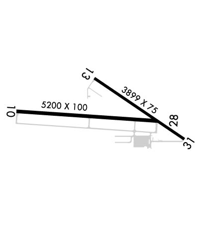
Runway Identifications
Runway Identification: 10/28Length: 5200 ft
Width: 100 ft
Surface: ASPHALT-FAIR CONDITION
Edge lights: Medium IntensityTreatment: NONE
| | Runway: 10 | | Runway: 28 |
| Mag heading: | 94° | Mag heading: | 274° |
| Rwy Slope: | -.67% Down | Rwy Slope: | .67% Up |
| Approach: | | Approach: | |
| Pattern: | Right Traffic | Pattern: | Right Traffic |
| Markings: | NONPRECISION INSTRUMENT | Markings: | NONPRECISION INSTRUMENT |
| Marking Condition: | FAIR | Marking Condition: | FAIR |
| Arresting Dev: | | Arresting Dev: | |
| Lat & Long: | N4420.0 W08902.0 | Lat. & Long.: | N4420.0 W08900.8 |
| Elev: | 840.0 ft. MSL | Elev: | 805.2 ft. MSL |
| TCH: | 40 ft. AGL | TCH: | 40 ft. AGL |
| Visual Glide Path: | 3.00 degrees | Visual Glide Path: | 3.00 degrees |
| Displaced Threshold: | No | Displaced Threshold: | No |
| Touchdown Zone: | YES | Touchdown Zone: | YES |
| Touchdown Elev.: | 840.2 feet | Touchdown Elev.: | 826.9 feet |
| Visual Glide Slope: | 2-Light PAPI on LEFT side of Runway; PAPI ON CONTINUOUSLY. | Visual Glide Slope: | 2-Light PAPI on LEFT side of Runway; PAPI ON CONTINUOUSLY. |
| RVR Equipment: | | RVR Equipment: | |
| RVV Equipment: | NO | RVV Equipment: | NO |
| Approach Lights: | | Approach Lights: | |
| REIL: | YES | REIL: | YES |
| Centerline Lights: | NO | Centerline Lights: | NO |
| Touchdown lights: | NO | Touchdown lights: | NO |
| Runway Category: | Runway with a Non-precision Approach having visibility minimums greater than 3/4 mile | Runway Category: | Runway with a Non-precision Approach having visibility minimums greater than 3/4 mile |
| Declared Distances: | | Declared Distances: | |
| Obstructions: | | Obstructions: | TREES |
| Marked: | | Marked: | NOT Marked/Lighted |
| Clearance slope: | 34:1 | Clearance slope: | 22:1 |
| Obstruction height: | | Obstruction height: | 59 feet AGL |
| Dist. from runway: | | Dist. from runway: | 1500 feet |
| Centerline offset: | | Centerline offset: | 350 feet right of centerline |
| Comments: | | Comments: | |
Runway Identification: 13/31Length: 3899 ft
Width: 75 ft
Surface: ASPHALT-POOR CONDITION
Edge lights: Medium IntensityTreatment: NONE
| | Runway: 13 | | Runway: 31 |
| Mag heading: | 124° | Mag heading: | 304° |
| Rwy Slope: | -.61% Down | Rwy Slope: | .61% Up |
| Approach: | | Approach: | |
| Pattern: | Left Traffic | Pattern: | Left Traffic |
| Markings: | NONPRECISION INSTRUMENT | Markings: | NONPRECISION INSTRUMENT |
| Marking Condition: | FAIR | Marking Condition: | FAIR |
| Arresting Dev: | | Arresting Dev: | |
| Lat & Long: | N4420.2 W08901.3 | Lat. & Long.: | N4419.8 W08900.6 |
| Elev: | 826.6 ft. MSL | Elev: | 802.8 ft. MSL |
| TCH: | 43 ft. AGL | TCH: | 38 ft. AGL |
| Visual Glide Path: | 4.00 degrees | Visual Glide Path: | 3.00 degrees |
| Displaced Threshold: | No | Displaced Threshold: | No |
| Touchdown Zone: | YES | Touchdown Zone: | YES |
| Touchdown Elev.: | 826.6 feet | Touchdown Elev.: | 818.7 feet |
| Visual Glide Slope: | 4-Light PAPI on LEFT side of Runway; PAPI ON CONTINUOUSLY. | Visual Glide Slope: | 2-Light PAPI on LEFT side of Runway; PAPI ON CONTINUOUSLY. |
| RVR Equipment: | | RVR Equipment: | |
| RVV Equipment: | NO | RVV Equipment: | NO |
| Approach Lights: | | Approach Lights: | |
| REIL: | NO | REIL: | NO |
| Centerline Lights: | NO | Centerline Lights: | NO |
| Touchdown lights: | NO | Touchdown lights: | NO |
| Runway Category: | Runway with a Visual Approach | Runway Category: | Runway with a Visual Approach |
| Declared Distances: | | Declared Distances: | |
| Obstructions: | TREES | Obstructions: | TREE |
| Marked: | NOT Marked/Lighted | Marked: | NOT Marked/Lighted |
| Clearance slope: | 15:1 | Clearance slope: | 5:1 |
| Obstruction height: | 75 feet AGL | Obstruction height: | 21 feet AGL |
| Dist. from runway: | 1330 feet | Dist. from runway: | 307 feet |
| Centerline offset: | 210 right of centerline | Centerline offset: | 120 feet right of centerline |
| Comments: | | Comments: | |

