Current Weather/Notams (Metars, TAFs, Notams, NWS Forecast, PIREPS, and nearby weather)
Customs Information Send updates to Support@FltPlan.com
Customs Not Available
Database effective 05/16/2024
Airport Diagram might not be current.
|
| Facility Name: | PERRYVILLE RGNL |
| City Name: | PERRYVILLE |
| County: | PERRY |
| State abbrev: | MO |
| State Name: | MISSOURI |
| | |
| Ownership: | PUBLICLY OWNED |
| Use: | OPEN TO THE PUBLIC |
| Owner's Name: | CITY OF PERRYVILLE |
| Address: | 215 N. WEST ST. |
| | PERRYVILLE, MO 63775 |
| Owner's Phone: | 573-547-2594 |
| | |
| Manager's Name: | BARBARA MAXWELL |
| Address: | 1856 HWY H |
| | PERRYVILLE, MO 63775 |
| Phone: | 573-605-1856 |
| | |
| FAA Region: | CENTRAL |
| FAA Field Office: | NONE |
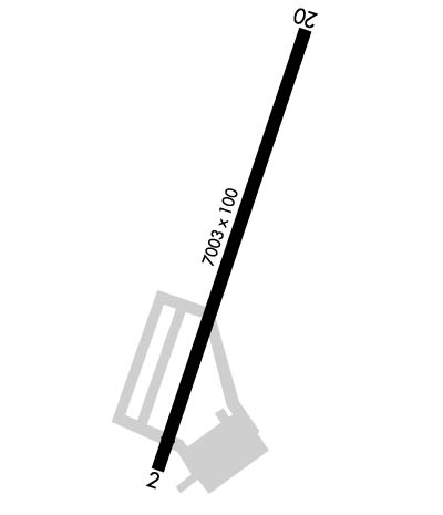
Runway Identifications
Runway Identification: 02/20Length: 7003 ft
Width: 100 ft
Surface: CONCRETE-GOOD CONDITION
Edge lights: Medium IntensityTreatment: NONE
| | Runway: 02 | | Runway: 20 |
| Mag heading: | 17° | Mag heading: | 197° |
| Rwy Slope: | .03% Up | Rwy Slope: | -.03% Down |
| Approach: | | Approach: | |
| Pattern: | Left Traffic | Pattern: | Left Traffic |
| Markings: | NONPRECISION INSTRUMENT | Markings: | NONPRECISION INSTRUMENT |
| Marking Condition: | GOOD | Marking Condition: | GOOD |
| Arresting Dev: | | Arresting Dev: | |
| Lat & Long: | N3751.6 W08951.9 | Lat. & Long.: | N3752.7 W08951.5 |
| Elev: | 368.3 ft. MSL | Elev: | 370.1 ft. MSL |
| TCH: | 45 ft. AGL | TCH: | 45 ft. AGL |
| Visual Glide Path: | 3.00 degrees | Visual Glide Path: | 3.00 degrees |
| Displaced Threshold: | 520 feet | Displaced Threshold: | No |
| Touchdown Zone: | YES | Touchdown Zone: | YES |
| Touchdown Elev.: | 370.2 feet | Touchdown Elev.: | 371.7 feet |
| Visual Glide Slope: | 4-Light PAPI on LEFT side of Runway | Visual Glide Slope: | 4-Light PAPI on LEFT side of Runway |
| RVR Equipment: | | RVR Equipment: | |
| RVV Equipment: | NO | RVV Equipment: | NO |
| Approach Lights: | | Approach Lights: | |
| REIL: | YES | REIL: | YES |
| Centerline Lights: | NO | Centerline Lights: | NO |
| Touchdown lights: | NO | Touchdown lights: | NO |
| Runway Category: | Runway with a Non-precision Approach having visibility minimums greater than 3/4 mile | Runway Category: | Runway with a Non-precision Approach having visibility minimums greater than 3/4 mile |
| Declared Distances: | TORA:7003' TODA:7003' ASDA:7003' LDA:6483' | Declared Distances: | TORA:6483' TODA:7003' ASDA:6483' LDA:6483' |
| Obstructions: | ROAD | Obstructions: | |
| Marked: | NOT Marked/Lighted | Marked: | |
| Clearance slope: | 23:1; 50:1 TO DSPLCD THLD. | Clearance slope: | 50:1 |
| Obstruction height: | 16 feet AGL | Obstruction height: | |
| Dist. from runway: | 570 feet | Dist. from runway: | |
| Centerline offset: | 250 right of centerline | Centerline offset: | |
| Comments: | | Comments: | |

