
| ||||||||||||||||||||||||||||||||||||||||||||
| ||||||||||||||||||||||||||||||||||||||||||||
| ||||||||||||||||||||||||||||||||||||||||||||
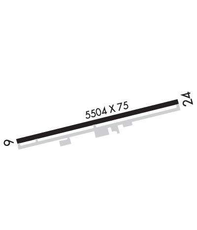
| Rwy | Rwy | |||||||
| 5504x75 | 5504' | 5504x75 | 5504' | |||||
| Runway ID | Single Wheel | Double Wheel | Double Tandem Wheel | Dual Double Wheel |
| 06/24 | 40,000 | 50,000 | 100,000 | N/A |
| H1 | N/A | N/A | N/A | N/A |
| These numbers are Advisory and are not limits. The Airport Manager should have more accurate Weight Limits | ||||
 Airport Diagram might not be current. | |
| Facility Name: | PAYSON |
| City Name: | PAYSON |
| County: | GILA |
| State abbrev: | AZ |
| State Name: | ARIZONA |
| Ownership: | PUBLICLY OWNED |
| Use: | OPEN TO THE PUBLIC |
| Owner's Name: | TOWN OF PAYSON |
| Address: | 303 N BEELINE HIGHWAY |
| PAYSON, AZ 85541 | |
| Owner's Phone: | 928-474-5242 |
| Manager's Name: | DENNIS DUEKER |
| Address: | 806 W. AIRPORT RD |
| PAYSON, AZ 85541 | |
| Phone: | 928-472-4748 |
| FAA Region: | WESTERN-PACIFIC |
| FAA Field Office: | PHX |
| Date | Sunrise | Sunset |
|---|---|---|
| 04/17/24 Wednesday | 5:51 | 18:59 |
| 04/18/24 Thursday | 5:49 | 19:00 |
| 04/19/24 Friday | 5:48 | 19:01 |
| 04/20/24 Saturday | 5:47 | 19:02 |
| 04/21/24 Sunday | 5:46 | 19:02 |
| 04/22/24 Monday | 5:45 | 19:03 |
| 04/23/24 Tuesday | 5:44 | 19:04 |
| 04/24/24 Wednesday | 5:42 | 19:05 |
| 04/25/24 Thursday | 5:41 | 19:06 |
| 04/26/24 Friday | 5:40 | 19:06 |
| 04/27/24 Saturday | 5:39 | 19:07 |
| 04/28/24 Sunday | 5:38 | 19:08 |
| 04/29/24 Monday | 5:37 | 19:09 |
| 04/30/24 Tuesday | 5:36 | 19:09 |
| Airport Attendance Schedule | MON-FRI 0700-1600, SAT-SUN 0700-1200 |
| Airport Status | OPERATIONAL (This Status can change at any time - please check NOTAMS) |
| Airport Lighting Schedule | DUSK-DAWN: ACTVT REIL RWY 06 & 24; PAPI RWY 06; MIRL RWY 06/24 - CTAF. MIRL RWY 06/24 PRESET LOW INTST; INCR INTST- CTAF. PAPI RWY 24 ON CONSLY. |
| Airport Storage Available | Tie Downs |
| Extra Services Available | Flight Instruction |
| Wind Indicator | YES - (lighted) |
| Control Tower | NO |
| CTAF Frequency | 122.800 |
| Unicom Frequency | 122.800 |
| Rotating Beacon Color | WG |
| Segmented Circle | YES |
| Landing Fee | NO |
| Airport Inspected | STATE - performed by PRIVATE CONTRACT PERSONNEL |
| Inspection Date | 05/10/2022 |
| Type of Fuel Available | Grade 100LL, JET A |
| Airframe Repair Service | MAJOR |
| Power Plant Repair Service | MAJOR |
| Latitude | N3415.4 |
| Longitude | W11120.4 (ESTIMATED) |
| Arpt Elevation | 5156ft (SURVEYED) |
| Magnetic Variation | 12E |
| 1 miles W | of PAYSON |
| Traffic Pattern Altitude | TPA PROP ENGINE 1043 FT, JET/MULTI-ENGINE & LARGE ENGINE 1543 FT, HEL 543 FT. |
| Sectional Chart | PHOENIX |
| Operations (Reported) | Yearly | Avg. Daily |
|---|---|---|
| General Aviation Transient | 20000 | 55 |
| General Aviation Local | 12000 | 33 |
| Air Taxi | 1750 | 5 |
| Commerical | 0 | 0 |
| Commuter | 0 | 0 |
| Military | 500 | 1 |
| Aircraft based on Field | |
|---|---|
| General Aviation Singles | 37 |
| General Aviation Multi | 1 |
| Jet Aircraft | 0 |
| General Aviation Helicopters | 0 |
| Military Aircraft | 0 |
| Gliders | 1 |
| Ultralights | 1 |
| FSS on field | NO |
| FSS tie-in | PRESCOTT |
| FSS Phone | 1-800-WX-BRIEF |
| Who issues Notams | PRC |
| Notam D service at airport | YES |
| ARTCC Name | ALBUQUERQUE |
| Airport Certification | |
| Aircraft Rescue & Firefighting Index | None |
| Airport of Entry | No |
| Custom Landing Rights | No |
| Joint Civil/Military | No |
| Military Landing rights | YES |
| NATIONAL PLAN OF INTEGRATED AIRPORT SYSTEMS (NPIAS) |
| GRANT AGREEMENTS UNDER FAAP/ADAP/AIP |
| ASSURANCES PURSUANT TO TITLE VI, CIVIL RIGHTS ACT OF 1964 |
| THIS AIRPORT HAS BEEN SURVEYED BY THE NATIONAL GEODETIC SURVEY. |
| 150 FT BLAST PADS ON RWY 06 & 24. |
| CAMPGROUND NEAR W RAMP. |
| DEP NOISE ABATEMENT PROC IN EFCT; TURN N 30 DEG FOR 2 NM. ARR/DEP BLW 1000 FT OVR TOWN NA. |
| SELF-SERVE CREDIT CARD FUEL AVBL W END. FOLLOW SIGNS IN SELF FUEL AREA. FUEL SVC - 928-970-0887. |
| RWY 06/2 4 RWY 24 CALM WIND RWY. |
Airport Communications & Frequencies:
| |||||||||
| Runway: 06 | Runway: 24 | ||
| Mag heading: | 64° | Mag heading: | 244° |
| Rwy Slope: | .33% Up | Rwy Slope: | -.33% Down |
| Approach: | Approach: | ||
| Pattern: | Left Traffic | Pattern: | Right Traffic |
| Markings: | NONPRECISION INSTRUMENT | Markings: | NONPRECISION INSTRUMENT |
| Marking Condition: | GOOD | Marking Condition: | GOOD |
| Arresting Dev: | Arresting Dev: | ||
| Lat & Long: | N3415.3 W11120.9 | Lat. & Long.: | N3415.5 W11119.8 |
| Elev: | 5138.6 ft. MSL | Elev: | 5156.8 ft. MSL |
| TCH: | 37 ft. AGL | TCH: | |
| Visual Glide Path: | 3.00 degrees | Visual Glide Path: | |
| Displaced Threshold: | No | Displaced Threshold: | No |
| Touchdown Zone: | YES | Touchdown Zone: | YES |
| Touchdown Elev.: | 5141.9 feet | Touchdown Elev.: | 5156.8 feet |
| Visual Glide Slope: | 2-Light PAPI on RIGHT side of Runway | Visual Glide Slope: | 2-Light PAPI on LEFT side of Runway |
| RVR Equipment: | RVR Equipment: | ||
| RVV Equipment: | NO | RVV Equipment: | NO |
| Approach Lights: | Approach Lights: | ||
| REIL: | YES | REIL: | YES |
| Centerline Lights: | NO | Centerline Lights: | NO |
| Touchdown lights: | NO | Touchdown lights: | NO |
| Runway Category: | Runway with a Visual Approach | Runway Category: | Runway with a Visual Approach |
| Declared Distances: | Declared Distances: | ||
| Comments: | 2-4 FT BERM 0-150 FT FM THR 85-125 FT L OF CNTRLN. | Comments: | 2-3 FT BRUSH 180 FT FM END ACRS THR; 2 FT BRUSH 20-170 FT FM THR 80-125 FT L OF CNTRLN. |
