Approach Charts
| FltPlan does not have IFR approach charts available for KP45. |
Current Weather/Notams (Metars, TAFs, Notams, NWS Forecast, PIREPS, and nearby weather)
Customs Information Send updates to Support@FltPlan.com
Customs Not Available
Database effective 05/16/2024
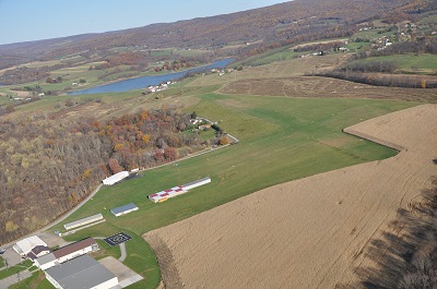
| Facility Name: | MOUNT PLEASANT/SCOTTDALE |
| City Name: | MOUNT PLEASANT |
| County: | FAYETTE |
| State abbrev: | PA |
| State Name: | PENNSYLVANIA |
| | |
| Ownership: | PRIVATELY OWNED |
| Use: | OPEN TO THE PUBLIC |
| Owner's Name: | MT. PLEASANT AIRPORT LLC |
| Address: | 276 AIRPORT RD |
| | MOUNT PLEASANT, PA 15666 |
| Owner's Phone: | 724-220-5556 |
| | |
| Manager's Name: | WILLIAM C. HOFFMAN |
| Address: | 276 AIRPORT RD |
| | MOUNT PLEASANT, PA 15666 |
| Phone: | 814-442-1747 |
| | |
| FAA Region: | EASTERN |
| FAA Field Office: | HAR |
Runway Identifications
Runway Identification: 06/24Length: 2037 ft
Width: 135 ft
Surface: GRASS-GOOD CONDITION
Edge lights: Treatment: NONE
| | Runway: 06 | | Runway: 24 |
| Mag heading: | 61° | Mag heading: | 241° |
| Rwy Slope: | 1.77% Up | Rwy Slope: | -1.77% Down |
| Approach: | | Approach: | |
| Pattern: | Left Traffic | Pattern: | Left Traffic |
| Markings: | NONSTANDARD | Markings: | NONSTANDARD |
| Marking Condition: | GOOD | Marking Condition: | GOOD |
| Arresting Dev: | | Arresting Dev: | |
| Lat & Long: | N4006.4 W07932.7 | Lat. & Long.: | N4006.6 W07932.3 |
| Elev: | 1114.0 ft. MSL | Elev: | 1150.0 ft. MSL |
| TCH: | | TCH: | |
| Visual Glide Path: | | Visual Glide Path: | |
| Displaced Threshold: | No | Displaced Threshold: | No |
| Touchdown Zone: | NO | Touchdown Zone: | NO |
| Touchdown Elev.: | | Touchdown Elev.: | |
| Visual Glide Slope: | | Visual Glide Slope: | |
| RVR Equipment: | | RVR Equipment: | |
| RVV Equipment: | NO | RVV Equipment: | NO |
| Approach Lights: | | Approach Lights: | |
| REIL: | NO | REIL: | NO |
| Centerline Lights: | NO | Centerline Lights: | NO |
| Touchdown lights: | NO | Touchdown lights: | NO |
| Runway Category: | Runway with a Visual Approach | Runway Category: | Runway with a Visual Approach |
| Declared Distances: | | Declared Distances: | |
| Obstructions: | TREES | Obstructions: | TREE |
| Marked: | NOT Marked/Lighted | Marked: | NOT Marked/Lighted |
| Clearance slope: | 13:1 | Clearance slope: | 6:1 |
| Obstruction height: | 39 feet AGL | Obstruction height: | 8 feet AGL |
| Dist. from runway: | 534 feet | Dist. from runway: | 55 feet |
| Centerline offset: | 172 right of centerline | Centerline offset: | 64 feet right of centerline |
| Comments: | | Comments: | |
Runway Identification: 14/32Length: 1625 ft
Width: 175 ft
Surface: GRASS-GOOD CONDITION
Edge lights: Treatment: NONE
| | Runway: 14 | | Runway: 32 |
| Mag heading: | 138° | Mag heading: | 318° |
| Rwy Slope: | 2.58% Up | Rwy Slope: | -2.58% Down |
| Approach: | | Approach: | |
| Pattern: | Left Traffic | Pattern: | Left Traffic |
| Markings: | NONSTANDARD | Markings: | NONSTANDARD |
| Marking Condition: | GOOD | Marking Condition: | GOOD |
| Arresting Dev: | | Arresting Dev: | |
| Lat & Long: | N4006.5 W07932.8 | Lat. & Long.: | N4006.4 W07932.5 |
| Elev: | 1093.0 ft. MSL | Elev: | 1135.0 ft. MSL |
| TCH: | | TCH: | |
| Visual Glide Path: | | Visual Glide Path: | |
| Displaced Threshold: | 565 feet | Displaced Threshold: | 250 feet |
| Touchdown Zone: | NO | Touchdown Zone: | NO |
| Touchdown Elev.: | | Touchdown Elev.: | |
| Visual Glide Slope: | | Visual Glide Slope: | |
| RVR Equipment: | | RVR Equipment: | |
| RVV Equipment: | NO | RVV Equipment: | NO |
| Approach Lights: | | Approach Lights: | |
| REIL: | NO | REIL: | NO |
| Centerline Lights: | NO | Centerline Lights: | NO |
| Touchdown lights: | NO | Touchdown lights: | NO |
| Runway Category: | Runway with a Visual Approach | Runway Category: | Runway with a Visual Approach |
| Declared Distances: | | Declared Distances: | |
| Obstructions: | ROAD; RD CROSSES CNTRLN 90 FT OUT ANGLING TO L SIDE OF THLD. | Obstructions: | TREES |
| Marked: | NOT Marked/Lighted | Marked: | NOT Marked/Lighted |
| Clearance slope: | RWY 14 APCH RATIO 20:1 TO 565 FT DTHR. | Clearance slope: | 9:1; RWY 32 APCH RATIO 57 FT TREES, 747 FT FM THLD, 64 FT R 17:1 TO 250 FT DTHR. |
| Obstruction height: | 12 feet AGL | Obstruction height: | 22 feet AGL |
| Dist. from runway: | 4 feet | Dist. from runway: | 204 feet |
| Centerline offset: | 100 left of centerline | Centerline offset: | 87 feet right of centerline |
| Comments: | | Comments: | |