Click here for more info on on SMS!

KP34

MIFFLINTOWN
MIFFLINTOWN
PA
Time Zone: Eastern
Lat: N 4035.9
Long: W 07724.3
Elev: 545
Var: +11
Longest Runway: 2627
CTAF: 122.8

FBO & Flight Services info for KP34

FBOs: Update your Fuel Prices

AIRPORT Fax: N/A Freq: 122.8
If you are an FBO, call 1-203-262-1700 to update your info or email: FltPlan.Advertising@garmin.com
Advertise your FBO on FltPlan.com

Runway & Approach Info for KP34
Rwy
Length
Land Dist**
Approach*
  Rwy
Length
Land Dist**
Approach*
08
2627x50  2395'          
 
  
26
  2627x50  2627'          
 
 * only ILS, LOC, LDA, and SDF approaches to a specific runway are shown
** For any Declared Landing Distance Available, please see A/FD or Approach plates
Runway Weight Capability (lbs.) Help
Runway IDSingle WheelDouble WheelDouble Tandem WheelDual Double Wheel
08/26N/AN/AN/AN/A
These numbers are Advisory and are not limits.   The Airport Manager should have more accurate Weight Limits
Approach Charts
Approaches    
Current Weather/Notams
Customs Information Send updates to Support@FltPlan.com
Customs Not Available
Database effective 05/16/2024
Airport Diagram of KP34
Airport Diagram might not be current.

Facility Name: MIFFLINTOWN
City Name: MIFFLINTOWN
County: JUNIATA
State abbrev: PA
State Name: PENNSYLVANIA
   
Ownership: PRIVATELY OWNED
Use: OPEN TO THE PUBLIC
Owner's Name: MIFFLINTOWN AIRPARK LLC
Address: 600 AIRPORT DR.
 MIFFLINTOWN, PA 17059
Owner's Phone: 717-436-2725
  
Manager's Name: BRUCE LISLE
Address: 600 AIRPORT DR.
 MIFFLINTOWN, PA 17059
Phone: 717-436-2725
   
FAA Region: EASTERN
FAA Field Office: HAR


Sunrise / Sunset times for MIFFLINTOWN

DateSunriseSunset
04/22/24 Monday6:2019:57
04/23/24 Tuesday6:1819:58
04/24/24 Wednesday6:1719:59
04/25/24 Thursday6:1520:00
04/26/24 Friday6:1420:01
04/27/24 Saturday6:1320:02
04/28/24 Sunday6:1120:03
04/29/24 Monday6:1020:04
04/30/24 Tuesday6:0920:05
05/01/24 Wednesday6:0820:06
05/02/24 Thursday6:0620:07
05/03/24 Friday6:0520:08
05/04/24 Saturday6:0420:09
05/05/24 Sunday6:0320:10

Airport Facilities

Airport Attendance ScheduleUNATTENDED
Airport Status OPERATIONAL (This Status can change at any time - please check NOTAMS)
Airport Lighting ScheduleACTVT LIRL RY 08/26, WIND INDICATOR LGTS - CTAF.; ACTIVATE ROTATING BCN - CTAF.
Airport Storage AvailableHanger
Extra Services AvailableNONE
Wind IndicatorYES - (lighted)
Control TowerNO
CTAF Frequency122.800
Unicom Frequency122.800
Rotating Beacon ColorWG
Segmented CircleNO
Landing FeeNO

Airport Inspection Data

Airport InspectedSTATE - performed by STATE AERONAUTICAL PERSONNEL
Inspection Date01/31/2024

Airport Services

Type of Fuel AvailableNone
Airframe Repair ServiceNONE
Power Plant Repair ServiceNONE

Geographic Data

LatitudeN4035.9
LongitudeW07724.3 (ESTIMATED)
Arpt Elevation545ft (ESTIMATED)
Magnetic Variation11W
2 miles Nof MIFFLINTOWN
Traffic Pattern Altitude
Sectional ChartDETROIT

Aircraft Data

Operations (Reported)YearlyAvg. Daily
General Aviation Transient 7502
General Aviation Local 30008
Air Taxi 500
Commerical 00
Commuter 00
Military 500
Aircraft based on Field
General Aviation Singles 19
General Aviation Multi 1
Jet Aircraft 0
General Aviation Helicopters 0
Military Aircraft 0
Gliders 0
Ultralights 0

FAA Services

FSS on field NO
FSS tie-in WILLIAMSPORT
FSS Phone 1-800-WX-BRIEF
Who issues Notams IPT
Notam D service at airport YES
ARTCC Name NEW YORK

Federal Status

Airport Certification
Aircraft Rescue & Firefighting IndexNone
Airport of EntryNo
Custom Landing RightsNo
Joint Civil/MilitaryNo
Military Landing rightsNo

Remarks

FOR CD CTC NEW YORK ARTCC AT 631-468-1425.
Airport Communications & Frequencies:
CTAF Frequency:
122.800
Unicom Frequency:
122.800
Remarks
  • APCH/DEP SVC PRVDD BY ZNY ARTCC ON 134.8/338.3 (PHILIPSBURG RCAG).
  • Runway Identifications
    Runway Identification: 08/26
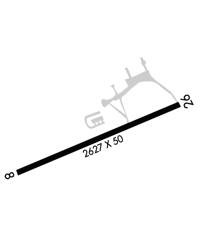
    Length: 2627 ft
    Width: 50 ft
    Surface: ASPHALT-GOOD CONDITION
    Edge lights: Low Intensity

    Treatment: NONE

     Runway: 08   Runway: 26
    Mag heading: N/AMag heading: N/A
    Rwy Slope: -.13% DownRwy Slope: .13% Up
    Approach: Approach:
    Pattern: Left TrafficPattern: Left Traffic
    Markings: BASICMarkings: NONSTANDARD
    Marking Condition: FAIRMarking Condition: FAIR; RWY NOT MKD FOR NPI APCH.
    Arresting Dev: Arresting Dev:
    Lat & Long: N4035.9  W07724.6Lat. & Long.: N4036.0  W07724.1
    Elev: 543.5 ft. MSLElev: 540.0 ft. MSL
    TCH: TCH:
    Visual Glide Path: Visual Glide Path:
    Displaced Threshold: 232 feetDisplaced Threshold: No
    Touchdown Zone: YESTouchdown Zone: YES
    Touchdown Elev.: 545.0 feetTouchdown Elev.: 545.0 feet
    Visual Glide Slope: Visual Glide Slope:
    RVR Equipment: RVR Equipment:
    RVV Equipment: NORVV Equipment: NO
    Approach Lights: Approach Lights:
    REIL: NOREIL: NO
    Centerline Lights: NOCenterline Lights: NO
    Touchdown lights: NOTouchdown lights: NO
    Runway Category: Runway with a Visual Approach; RWY 8 CLSD TO NGT VISUAL APCH DUE TO SEV APCH AND PRIM SFC OBSTNS.Runway Category: Runway with a Non-precision Approach
    Declared Distances: Declared Distances:
    Obstructions: TREESObstructions: TREES
    Marked: NOT Marked/LightedMarked: NOT Marked/Lighted
    Clearance slope: APCH SLOPE 14:1 TO DSPLCD THLD.Clearance slope: 16:1
    Obstruction height: 40 feet AGLObstruction height: 28 feet AGL
    Dist. from runway: 221 feetDist. from runway: 675 feet
    Centerline offset: 245 right of centerlineCenterline offset: 143 feet right of centerline
    Comments: RY 08 HAS 20-50 FT HIGH TREES 150 FT FM RY END TO 430 FT BEHIND RY END, 60-170 FT LEFT OF CNTRLN; 20-40 FT HIGH STRUCTURES AND TREES 50 FT FM RY END TO 530 FT BEHIND RY END, 90-160 FT RIGHT OF CNTRLN.Comments:
    C:/P: