Approach Charts
| FltPlan does not have IFR approach charts available for KP03. |
Current Weather/Notams (Metars, TAFs, Notams, NWS Forecast, PIREPS, and nearby weather)
Customs Information Send updates to Support@FltPlan.com
Customs Not Available
Database effective 05/16/2024
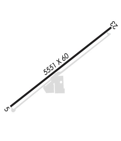
Airport Diagram might not be current.
|
| Facility Name: | COCHISE COLLEGE |
| City Name: | DOUGLAS |
| County: | COCHISE |
| State abbrev: | AZ |
| State Name: | ARIZONA |
| | |
| Ownership: | PUBLICLY OWNED |
| Use: | OPEN TO THE PUBLIC |
| Owner's Name: | COCHISE COLLEGE |
| Address: | 4190 W. HWY 80 |
| | DOUGLAS, AZ 85607-6190 |
| Owner's Phone: | 520-417-4114 |
| | |
| Manager's Name: | BELINDA BURNETT |
| Address: | COCHISE COMMUNITY COLLEGE, 4190 W. HIGHWAY 80 |
| | DOUGLAS, AZ 85607-6190 |
| Phone: | 520-417-4114 |
| | |
| FAA Region: | WESTERN-PACIFIC |
| FAA Field Office: | PHX |
Runway Identifications
Runway Identification: 05/23Length: 5551 ft
Width: 60 ft
Surface: ASPHALT-GOOD CONDITION
Edge lights: Medium IntensityTreatment: NONE
| | Runway: 05 | | Runway: 23 |
| Mag heading: | 45° | Mag heading: | 225° |
| Rwy Slope: | -.66% Down | Rwy Slope: | .66% Up |
| Approach: | | Approach: | |
| Pattern: | Left Traffic | Pattern: | Left Traffic |
| Markings: | BASIC | Markings: | BASIC |
| Marking Condition: | GOOD | Marking Condition: | GOOD |
| Arresting Dev: | | Arresting Dev: | |
| Lat & Long: | N3122.0 W10941.8 | Lat. & Long.: | N3122.5 W10940.9 |
| Elev: | 4146.0 ft. MSL | Elev: | 4109.6 ft. MSL |
| TCH: | | TCH: | |
| Visual Glide Path: | 3.00 degrees | Visual Glide Path: | 3.00 degrees |
| Displaced Threshold: | No | Displaced Threshold: | 450 feet |
| Touchdown Zone: | NO | Touchdown Zone: | NO |
| Touchdown Elev.: | | Touchdown Elev.: | |
| Visual Glide Slope: | 4-Light PAPI on LEFT side of Runway | Visual Glide Slope: | 4-Light PAPI on LEFT side of Runway |
| RVR Equipment: | | RVR Equipment: | |
| RVV Equipment: | NO | RVV Equipment: | NO |
| Approach Lights: | | Approach Lights: | |
| REIL: | NO | REIL: | NO |
| Centerline Lights: | NO | Centerline Lights: | NO |
| Touchdown lights: | NO | Touchdown lights: | NO |
| Runway Category: | Runway with a Visual Approach | Runway Category: | Runway with a Visual Approach |
| Declared Distances: | TORA:5441' TODA:5551' ASDA:5441' LDA:5441' | Declared Distances: | TORA:5551' TODA:5551' LDA:5103' |
| Obstructions: | ROAD | Obstructions: | ROAD |
| Marked: | NOT Marked/Lighted | Marked: | NOT Marked/Lighted |
| Clearance slope: | 11:1 | Clearance slope: | APCH SLOPE 42:1 TO DTHR. |
| Obstruction height: | 15 feet AGL | Obstruction height: | 15 feet AGL |
| Dist. from runway: | 366 feet | Dist. from runway: | 201 feet |
| Centerline offset: | 140 left of centerline | Centerline offset: | 60 feet left of centerline |
| Comments: | 2-4 FT WEEDS 100-200 FT FM THR ACRS APCH. | Comments: | 15 FT ROAD 70 FT FM THR 250 FT L OF CNTRLN; 4 FT FENCE 55 FT FM THR 50-250 FT L OF CNTRLN; +2-3 FT BRUSH 20-200 FT FM THR ACRS APCH. |

