
| ||||||||||||||||||||||||||||||||
| ||||||||||||||||||||||||||||||||
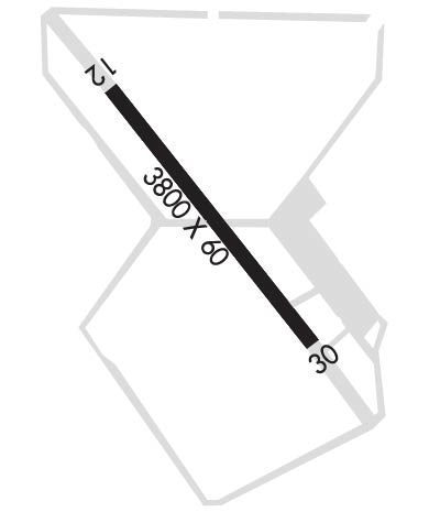
| Rwy | Rwy | |||||||
| 3800x60 | 3800' | 3800x60 | 3800' | |||||
| Runway ID | Single Wheel | Double Wheel | Double Tandem Wheel | Dual Double Wheel |
| 12/30 | 12,000 | N/A | N/A | N/A |
| These numbers are Advisory and are not limits. The Airport Manager should have more accurate Weight Limits | ||||
| FltPlan does not have IFR approach charts available for KP01. |
 Airport Diagram might not be current. | |
| Facility Name: | ERIC MARCUS MUNI |
| City Name: | AJO |
| County: | PIMA |
| State abbrev: | AZ |
| State Name: | ARIZONA |
| Ownership: | PUBLICLY OWNED |
| Use: | OPEN TO THE PUBLIC |
| Owner's Name: | PIMA COUNTY |
| Address: | 201 NORTH STONE AVENUE |
| TUCSON, AZ 85701-1215 | |
| Owner's Phone: | (520) 724-6462 |
| Manager's Name: | ANNA STEINER; ADDITIONAL CONTACT: JAVIER GARCIA 520-387-6051 OR 520-349-2538 (C). |
| Address: | 201 N. STONE AVE. |
| TUCSON, AZ 85701-1215 | |
| Phone: | 520-627-3951 |
| FAA Region: | WESTERN-PACIFIC |
| FAA Field Office: | PHX |
| Date | Sunrise | Sunset |
|---|---|---|
| 04/24/24 Wednesday | 5:51 | 19:08 |
| 04/25/24 Thursday | 5:50 | 19:09 |
| 04/26/24 Friday | 5:49 | 19:10 |
| 04/27/24 Saturday | 5:48 | 19:10 |
| 04/28/24 Sunday | 5:47 | 19:11 |
| 04/29/24 Monday | 5:46 | 19:12 |
| 04/30/24 Tuesday | 5:45 | 19:13 |
| 05/01/24 Wednesday | 5:44 | 19:13 |
| 05/02/24 Thursday | 5:43 | 19:14 |
| 05/03/24 Friday | 5:42 | 19:15 |
| 05/04/24 Saturday | 5:41 | 19:15 |
| 05/05/24 Sunday | 5:40 | 19:16 |
| 05/06/24 Monday | 5:39 | 19:17 |
| 05/07/24 Tuesday | 5:39 | 19:18 |
| Airport Attendance Schedule | UNATTENDED |
| Airport Status | OPERATIONAL (This Status can change at any time - please check NOTAMS) |
| Airport Lighting Schedule | MIRL RY 12/30, PAPI RYS 12 & 30 PRESET LOW INTST SS-SR; TO INCR INTST ACTVT - CTAF. |
| Airport Storage Available | Tie Downs |
| Extra Services Available | NONE |
| Wind Indicator | YES - (lighted) |
| Control Tower | NO |
| CTAF Frequency | 122.900 |
| Unicom Frequency | |
| Rotating Beacon Color | WG |
| Segmented Circle | YES |
| Landing Fee | NO |
| Airport Inspected | STATE - performed by PRIVATE CONTRACT PERSONNEL |
| Inspection Date | 04/19/2023 |
| Type of Fuel Available | None |
| Airframe Repair Service | None |
| Power Plant Repair Service | None |
| Latitude | N3227.2 |
| Longitude | W11251.7 (ESTIMATED) |
| Arpt Elevation | 1458ft (ESTIMATED) |
| Magnetic Variation | 09E |
| 5 miles N | of AJO |
| Traffic Pattern Altitude | |
| Sectional Chart | PHOENIX |
| Operations (Reported) | Yearly | Avg. Daily |
|---|---|---|
| General Aviation Transient | 1280 | 4 |
| General Aviation Local | 320 | 1 |
| Air Taxi | 0 | 0 |
| Commerical | 0 | 0 |
| Commuter | 0 | 0 |
| Military | 0 | 0 |
| Aircraft based on Field | |
|---|---|
| General Aviation Singles | 4 |
| General Aviation Multi | 0 |
| Jet Aircraft | 0 |
| General Aviation Helicopters | 0 |
| Military Aircraft | 0 |
| Gliders | 0 |
| Ultralights | 1 |
| FSS on field | NO |
| FSS tie-in | PRESCOTT |
| FSS Phone | 1-800-WX-BRIEF |
| Who issues Notams | PRC |
| Notam D service at airport | YES |
| ARTCC Name | ALBUQUERQUE |
| Airport Certification | |
| Aircraft Rescue & Firefighting Index | None |
| Airport of Entry | No |
| Custom Landing Rights | No |
| Joint Civil/Military | No |
| Military Landing rights | YES |
| NATIONAL PLAN OF INTEGRATED AIRPORT SYSTEMS (NPIAS) |
| GRANT AGREEMENTS UNDER FAAP/ADAP/AIP |
| SURPLUS PROPERTY AGREEMENT UNDER PUBLIC LAW 289 |
| ASSURANCES PURSUANT TO TITLE VI, CIVIL RIGHTS ACT OF 1964 |
| AGREEMENT UNDER DLAND OR DCLA HAS EXPIRED. |
| HEAVY MILITARY JET TFC INVOF ARPT. |
| AIRCRAFT RAMP HAS 6 FT-10 FT RAISED PANELS ACROSS RAMP 70 FT IN FRONT OF T-HANGARS & MARKED WITH PAINT. |
| LIVESTOCK ON OR IN VICINITY OF AIRPORT. |
| MOUNTAINS IN ALL QUADRANTS. |
| 4 FT DIKE 1340 FT FM THR RWY 30. |
| RWY 12/30 ASPH & GRAVEL STOPWAY 1400 FT NW END, 1065 FT STOPWAY SE END. ASPH BROKEN, SHORT BRUSH GROWING ON STOPWAYS BYD 200 FT FM THRS. |
| RY 12/30 HAS A NUMBER OF 2 FT BY 2 FT EXPOSED CONC CABLE MARKERS BOTH SIDES OF RY WITHIN 20 FT OF PAVED SFC. |
| Runway: 12 | Runway: 30 | ||
| Mag heading: | N/A | Mag heading: | N/A |
| Approach: | Approach: | ||
| Pattern: | Left Traffic | Pattern: | Left Traffic |
| Markings: | BASIC | Markings: | BASIC |
| Marking Condition: | FAIR | Marking Condition: | FAIR |
| Arresting Dev: | Arresting Dev: | ||
| Lat & Long: | N3227.4 W11251.9 | Lat. & Long.: | N3227.0 W11251.4 |
| Elev: | N/A | Elev: | N/A |
| TCH: | 40 ft. AGL | TCH: | 40 ft. AGL |
| Visual Glide Path: | Visual Glide Path: | ||
| Displaced Threshold: | No | Displaced Threshold: | No |
| Touchdown Zone: | NO | Touchdown Zone: | NO |
| Touchdown Elev.: | Touchdown Elev.: | ||
| Visual Glide Slope: | 2-Light PAPI on LEFT side of Runway; PAPI OUT OF SERVICE INDEF. | Visual Glide Slope: | 2-Light PAPI on LEFT side of Runway; PAPI OUT OF SERVICE INDEF. |
| RVR Equipment: | RVR Equipment: | ||
| RVV Equipment: | NO | RVV Equipment: | NO |
| Approach Lights: | Approach Lights: | ||
| REIL: | NO | REIL: | NO |
| Centerline Lights: | NO | Centerline Lights: | NO |
| Touchdown lights: | NO | Touchdown lights: | NO |
| Runway Category: | Runway with a Visual Approach | Runway Category: | Runway with a Visual Approach |
| Declared Distances: | Declared Distances: |
