Click here for more info on on SMS!

KOZA

OZONA MUNI
OZONA
TX
Time Zone: Central
Lat: N 3044.1
Long: W 10112.1
Elev: 2377
Var: -08
Longest Runway: 6003
AWOS: 118.42
CTAF: 122.8

FBO & Flight Services info for KOZA

FBOs: Update your Fuel Prices

MC CLEARY ACFTPh: 325-392-2030 Fax: 325-392-2030 Freq: 122.8
Service
Jet
100LL
SAF
MoGas
Fuel Avail: JET A INCLUDES PRIST.
Full5.805.90    Last Update: 04/07/2024 12:17

Self        
 Address: 319 CR308   OZONA, TX 76943
AWOSPh: 325-392-2051
-
Freq: 118.42  
If you are an FBO, call 1-203-262-1700 to update your info or email: FltPlan.Advertising@garmin.com
Advertise your FBO on FltPlan.com

Runway & Approach Info for KOZA
Rwy
Length
Land Dist**
Approach*
  Rwy
Length
Land Dist**
Approach*
16
6003x75  6003'          
 
  
34
  6003x75  6003'          
 
 * only ILS, LOC, LDA, and SDF approaches to a specific runway are shown
** For any Declared Landing Distance Available, please see A/FD or Approach plates
Runway Weight Capability (lbs.) Help
Runway IDSingle WheelDouble WheelDouble Tandem WheelDual Double Wheel
16/3430,000N/AN/AN/A
These numbers are Advisory and are not limits.   The Airport Manager should have more accurate Weight Limits
Approach Charts
Approaches    
Current Weather/Notams
Customs Information Send updates to Support@FltPlan.com
Customs Not Available
Database effective 05/16/2024
Airport Diagram of KOZA
Airport Diagram might not be current.

Facility Name: OZONA MUNI
City Name: OZONA
County: CROCKETT
State abbrev: TX
State Name: TEXAS
   
Ownership: PUBLICLY OWNED
Use: OPEN TO THE PUBLIC
Owner's Name: CROCKETT COUNTY
Address: PO BOX 1857 COUNTY COURTHOUSE
 OZONA, TX 76943
Owner's Phone: 325-392-2965
  
Manager's Name: CHARLES MCCLEARY
Address: BOX 426; ARPT PHYS ADDRESS 319 CR 308.
 OZONA, TX 76943
Phone: 325-392-2030
   
FAA Region: SOUTHWEST
FAA Field Office: TEX


Sunrise / Sunset times for OZONA MUNI

DateSunriseSunset
04/23/24 Tuesday7:0820:19
04/24/24 Wednesday7:0720:19
04/25/24 Thursday7:0620:20
04/26/24 Friday7:0520:21
04/27/24 Saturday7:0420:21
04/28/24 Sunday7:0320:22
04/29/24 Monday7:0220:23
04/30/24 Tuesday7:0120:23
05/01/24 Wednesday7:0020:24
05/02/24 Thursday6:5920:25
05/03/24 Friday6:5820:25
05/04/24 Saturday6:5820:26
05/05/24 Sunday6:5720:27
05/06/24 Monday6:5620:27

Airport Facilities

Airport Attendance ScheduleMON-FRI 0800-1700
Airport Status OPERATIONAL (This Status can change at any time - please check NOTAMS)
Airport Lighting ScheduleRWY 16/34 MIRL PRESET MED INTST; TO INCR INTST ACTVT - CTAF.
Airport Storage AvailableTie Downs
Extra Services AvailableNONE
Wind IndicatorYES - (lighted)
Control TowerNO
CTAF Frequency122.800
Unicom Frequency122.800
Rotating Beacon ColorWG
Segmented CircleYES
Landing FeeNO

Airport Inspection Data

Airport InspectedSTATE - performed by PRIVATE CONTRACT PERSONNEL
Inspection Date03/05/2024

Airport Services

Type of Fuel AvailableGrade 100LL, JET A (freeze point -40C); -10FOR AFT HRS FUEL CALL 325-226-2628.
Airframe Repair ServiceNone
Power Plant Repair ServiceNone

Geographic Data

LatitudeN3044.1
LongitudeW10112.1 (ESTIMATED)
Arpt Elevation2376ft (SURVEYED)
Magnetic Variation08E
1 miles Nof OZONA
Traffic Pattern Altitude
Sectional ChartSAN ANTONIO

Aircraft Data

Operations (Reported)YearlyAvg. Daily
General Aviation Transient 12003
General Aviation Local 24007
Air Taxi 00
Commerical 00
Commuter 00
Military 750
Aircraft based on Field
General Aviation Singles 16
General Aviation Multi 1
Jet Aircraft 0
General Aviation Helicopters 1
Military Aircraft 0
Gliders 0
Ultralights 0

FAA Services

FSS on field NO
FSS tie-in SAN ANGELO
FSS Phone 1-800-WX-BRIEF
Who issues Notams SJT
Notam D service at airport YES
ARTCC Name HOUSTON

Federal Status

Airport Certification
Aircraft Rescue & Firefighting IndexNone
Airport of EntryNo
Custom Landing RightsNo
Joint Civil/MilitaryNo
Military Landing rightsNo

Federal Agreements

NATIONAL PLAN OF INTEGRATED AIRPORT SYSTEMS (NPIAS)

Remarks

FOR CD CTC HOUSTON ARTCC AT 281-230-5622.
Airport Communications & Frequencies:
CTAF Frequency:
122.800
Unicom Frequency:
122.800
Remarks
  • APCH/DEP CTL SVC PRVDD BY HOUSTON ARTCC ON FREQS 125.75/346.4 (ROCK SPRINGS RCAG).
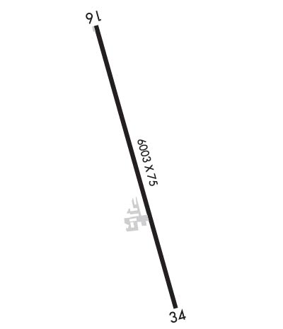
  • Runway Identifications
    Runway Identification: 16/34
    Length: 6003 ft
    Width: 75 ft
    Surface: ASPHALT-GOOD CONDITION
    Edge lights: Medium Intensity

    Treatment: NONE

     Runway: 16   Runway: 34
    Mag heading: 160°Mag heading: 340°
    Rwy Slope: -.36% DownRwy Slope: .36% Up
    Approach: Approach:
    Pattern: Left TrafficPattern: Left Traffic
    Markings: NONPRECISION INSTRUMENTMarkings: NONPRECISION INSTRUMENT
    Marking Condition: GOODMarking Condition: GOOD
    Arresting Dev: Arresting Dev:
    Lat & Long: N3044.6  W10112.3Lat. & Long.: N3043.6  W10112.0
    Elev: 2376.8 ft. MSLElev: 2355.3 ft. MSL
    TCH: 39 ft. AGLTCH: 35 ft. AGL
    Visual Glide Path: 3.00 degreesVisual Glide Path: 3.00 degrees
    Displaced Threshold: NoDisplaced Threshold: No
    Touchdown Zone: YESTouchdown Zone: YES
    Touchdown Elev.: 2376.9 feetTouchdown Elev.: 2366.7 feet
    Visual Glide Slope: 4-Light PAPI on LEFT side of RunwayVisual Glide Slope: 4-Light PAPI on LEFT side of Runway
    RVR Equipment: RVR Equipment:
    RVV Equipment: NORVV Equipment: NO
    Approach Lights: Approach Lights:
    REIL: NOREIL: NO
    Centerline Lights: NOCenterline Lights: NO
    Touchdown lights: NOTouchdown lights: NO
    Runway Category: Runway with a Non-precision Approach having visibility minimums greater than 3/4 mileRunway Category: Runway with a Visual Approach
    Declared Distances: Declared Distances:
    Obstructions: TREESObstructions: POLE
    Marked: NOT Marked/LightedMarked: NOT Marked/Lighted
    Clearance slope: 15:1Clearance slope: 20:1
    Obstruction height: 40 feet AGLObstruction height: 50 feet AGL
    Dist. from runway: 830 feetDist. from runway: 1200 feet
    Centerline offset: 350 right of centerlineCenterline offset: 45 feet right of centerline
    Comments: Comments:
    C:3/P: