Click here for more info on on SMS!

KOXV

KNOXVILLE MUNI
KNOXVILLE
IA
Time Zone: Central
Lat: N 4117.9
Long: W 09306.8
Elev: 928
Var: -02
Longest Runway: 4000
AWOS: 119.77
CTAF: 122.8

FBO & Flight Services info for KOXV

FBOs: Update your Fuel Prices
Providing high quality fuel and services to you and your customers, from Phillips 66 Aviation.
Ph: 641-842-4423
-
Freq: 122.8Website-
Service
Jet
100LL
SAF
MoGas
Fuel Avail: PRIST PREMIXED
Full5.906.15    Last Update: 04/09/2024 13:15

Self        
Misc. Info: Address: 1545 HIGHWAY 14   KNOXVILLE, IA 50138

AWOSPh: 641-828-8406
-
Freq: 119.77  
If you are an FBO, call 1-203-262-1700 to update your info or email: FltPlan.Advertising@garmin.com
Advertise your FBO on FltPlan.com

Runway & Approach Info for KOXV
Rwy
Length
Land Dist**
Approach*
  Rwy
Length
Land Dist**
Approach*
15
4000x75  4000'          
 
  
33
  4000x75  4000'          
 
 * only ILS, LOC, LDA, and SDF approaches to a specific runway are shown
** For any Declared Landing Distance Available, please see A/FD or Approach plates
Runway Weight Capability (lbs.) Help
Runway IDSingle WheelDouble WheelDouble Tandem WheelDual Double Wheel
15/3328,00048,000N/AN/A
These numbers are Advisory and are not limits.   The Airport Manager should have more accurate Weight Limits
Approach Charts
Approaches    
Current Weather/Notams
Customs Information Send updates to Support@FltPlan.com
Customs Not Available
Database effective 05/16/2024
Airport Diagram of KOXV
Airport Diagram might not be current.

Facility Name: KNOXVILLE MUNI
City Name: KNOXVILLE
County: MARION
State abbrev: IA
State Name: IOWA
   
Ownership: PUBLICLY OWNED
Use: OPEN TO THE PUBLIC
Owner's Name: CITY OF KNOXVILLE
Address: 305 SOUTH 3RD
 KNOXVILLE, IA 50138
Owner's Phone: 641-842-3147
  
Manager's Name: KATHERINE SHAWVER
Address: 1545 HWY 14 SOUTH
 KNOXVILLE, IA 50138
Phone: 702-466-9560
   
FAA Region: CENTRAL
FAA Field Office: NONE


Sunrise / Sunset times for KNOXVILLE MUNI

DateSunriseSunset
04/22/24 Monday6:2120:01
04/23/24 Tuesday6:2020:02
04/24/24 Wednesday6:1820:03
04/25/24 Thursday6:1720:04
04/26/24 Friday6:1620:05
04/27/24 Saturday6:1420:06
04/28/24 Sunday6:1320:07
04/29/24 Monday6:1120:09
04/30/24 Tuesday6:1020:10
05/01/24 Wednesday6:0920:11
05/02/24 Thursday6:0820:12
05/03/24 Friday6:0620:13
05/04/24 Saturday6:0520:14
05/05/24 Sunday6:0420:15

Airport Facilities

Airport Attendance Schedule7 Days A Week DAWN-DUSK; FOR SERVICE AFTER HOURS CALL 641-842-4423 OR 641-891-6824.
Airport Status OPERATIONAL (This Status can change at any time - please check NOTAMS)
Airport Lighting ScheduleACTVT MIRL RY 15/33 AND PAPI RYS 15 & 33 AND REIL RYS 15 & 33 - CTAF.
Airport Storage AvailableTie Downs, Hanger
Extra Services AvailableCharter, Flight Instruction, Aircraft Rental, Aircraft Sales
Wind IndicatorYES - (lighted)
Control TowerNO
CTAF Frequency122.800
Unicom Frequency122.800
Rotating Beacon ColorWG
Segmented CircleNO
Landing FeeNO

Airport Inspection Data

Airport InspectedSTATE - performed by STATE AERONAUTICAL PERSONNEL
Inspection Date09/06/2023

Airport Services

Type of Fuel AvailableGrade 100LL, JET A (freeze point -40C)
Airframe Repair ServiceMAJOR
Power Plant Repair ServiceMAJOR

Geographic Data

LatitudeN4117.9
LongitudeW09306.8 (ESTIMATED)
Arpt Elevation928ft (SURVEYED)
Magnetic Variation02E
2 miles Sof KNOXVILLE
Traffic Pattern Altitude
Sectional ChartOMAHA

Aircraft Data

Operations (Reported)YearlyAvg. Daily
General Aviation Transient 510214
General Aviation Local 567016
Air Taxi 1130
Commerical 00
Commuter 00
Military 1150
Aircraft based on Field
General Aviation Singles 32
General Aviation Multi 0
Jet Aircraft 0
General Aviation Helicopters 3
Military Aircraft 0
Gliders 0
Ultralights 1

FAA Services

FSS on field NO
FSS tie-in FORT DODGE
FSS Phone 1-800-WX-BRIEF
Who issues Notams OXV
Notam D service at airport YES
ARTCC Name CHICAGO

Federal Status

Airport Certification
Aircraft Rescue & Firefighting IndexNone
Airport of EntryNo
Custom Landing RightsNo
Joint Civil/MilitaryNo
Military Landing rightsYES

Federal Agreements

NATIONAL PLAN OF INTEGRATED AIRPORT SYSTEMS (NPIAS)
GRANT AGREEMENTS UNDER FAAP/ADAP/AIP
ASSURANCES PURSUANT TO TITLE VI, CIVIL RIGHTS ACT OF 1964

Remarks

FOR CD CTC DES MOINES ATCT AT 515-974- 8016.
Airport Communications & Frequencies:
CTAF Frequency:
122.800
Unicom Frequency:
122.800
DES MOINES Primary Approach Frequencies:  
123.9
307.15
DES MOINES Primary Departure Frequencies:  
123.9
307.15
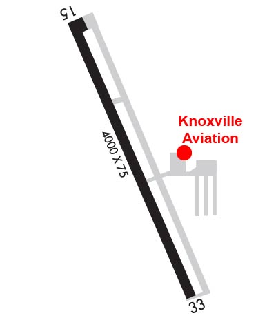
Runway Identifications
Runway Identification: 15/33
Length: 4000 ft
Width: 75 ft
Surface: CONCRETE-GOOD CONDITION
Edge lights: Medium Intensity

Treatment: NONE
Weight: PCN 5 /R/C/W/U

 Runway: 15   Runway: 33
Mag heading: 154°Mag heading: 334°
Rwy Slope: .09% UpRwy Slope: -.09% Down
Approach: Approach:
Pattern: Left TrafficPattern: Left Traffic
Markings: NONPRECISION INSTRUMENTMarkings: NONPRECISION INSTRUMENT
Marking Condition: GOODMarking Condition: GOOD
Arresting Dev: Arresting Dev:
Lat & Long: N4118.2  W09307.0Lat. & Long.: N4117.6  W09306.6
Elev: 923.9 ft. MSLElev: 927.4 ft. MSL
TCH: 32 ft. AGLTCH: 32 ft. AGL
Visual Glide Path: 3.00 degreesVisual Glide Path: 3.00 degrees
Displaced Threshold: NoDisplaced Threshold: No
Touchdown Zone: YESTouchdown Zone: YES
Touchdown Elev.: 927.8 feetTouchdown Elev.: 928.3 feet
Visual Glide Slope: 2-Light PAPI on LEFT side of RunwayVisual Glide Slope: 2-Light PAPI on LEFT side of Runway
RVR Equipment: RVR Equipment:
RVV Equipment: NORVV Equipment: NO
Approach Lights: Approach Lights:
REIL: YESREIL: YES
Centerline Lights: NOCenterline Lights: NO
Touchdown lights: NOTouchdown lights: NO
Runway Category: Runway with a Non-precision Approach having visibility minimums greater than 3/4 mileRunway Category: Runway with a Non-precision Approach having visibility minimums greater than 3/4 mile
Declared Distances: Declared Distances:
Obstructions: POLEObstructions: TREE
Marked: NOT Marked/LightedMarked: NOT Marked/Lighted
Clearance slope: 23:1Clearance slope: 24:1
Obstruction height: 26 feet AGLObstruction height: 23 feet AGL
Dist. from runway: 819 feetDist. from runway: 773 feet
Centerline offset: 325 left of centerlineCenterline offset: 99 feet right of centerline
Comments: Comments:
C:1/P: