Current Weather/Notams (Metars, TAFs, Notams, NWS Forecast, PIREPS, and nearby weather)
Customs Information Send updates to Support@FltPlan.com
Customs Not Available
Database effective 05/16/2024
Airport Diagram might not be current.
|
| Facility Name: | OCEAN CITY MUNI |
| City Name: | OCEAN CITY |
| County: | WORCESTER |
| State abbrev: | MD |
| State Name: | MARYLAND |
| | |
| Ownership: | PUBLICLY OWNED |
| Use: | OPEN TO THE PUBLIC |
| Owner's Name: | MAYOR & CITY COUNCIL |
| Address: | CITY HALL, PO BOX 158 |
| | OCEAN CITY, MD 21842 |
| Owner's Phone: | 410-213-2471 |
| | |
| Manager's Name: | JAIME GIANDOMENICO |
| Address: | 12724 AIRPORT RD |
| | BERLIN, MD 21811 |
| Phone: | (443) 235-4434 |
| | |
| FAA Region: | EASTERN |
| FAA Field Office: | DCA |
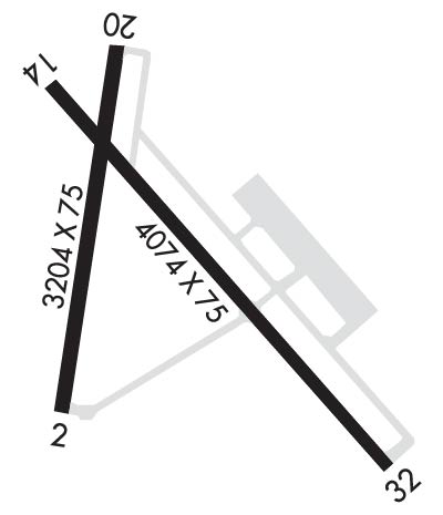
Runway Identifications
Runway Identification: 02/20Length: 3204 ft
Width: 75 ft
Surface: ASPHALT-GOOD CONDITION
Edge lights: Medium IntensityTreatment: NONE
| | Runway: 02 | | Runway: 20 |
| Mag heading: | 22° | Mag heading: | 202° |
| Rwy Slope: | .07% Up | Rwy Slope: | -.07% Down |
| Approach: | | Approach: | |
| Pattern: | Left Traffic | Pattern: | Left Traffic |
| Markings: | NONPRECISION INSTRUMENT | Markings: | NONPRECISION INSTRUMENT |
| Marking Condition: | GOOD | Marking Condition: | GOOD |
| Arresting Dev: | | Arresting Dev: | |
| Lat & Long: | N3818.4 W07507.7 | Lat. & Long.: | N3818.9 W07507.5 |
| Elev: | 8.8 ft. MSL | Elev: | 11.1 ft. MSL |
| TCH: | 40 ft. AGL | TCH: | 42 ft. AGL |
| Visual Glide Path: | 3.00 degrees | Visual Glide Path: | 4.00 degrees |
| Displaced Threshold: | No | Displaced Threshold: | No |
| Touchdown Zone: | YES | Touchdown Zone: | YES |
| Touchdown Elev.: | 11.5 feet | Touchdown Elev.: | 11.5 feet |
| Visual Glide Slope: | 2-Light PAPI on LEFT side of Runway; PAPI UNUSBL 6 DEG LEFT OF CNTRLN. | Visual Glide Slope: | 2-Light PAPI on LEFT side of Runway |
| RVR Equipment: | | RVR Equipment: | |
| RVV Equipment: | NO | RVV Equipment: | NO |
| Approach Lights: | | Approach Lights: | |
| REIL: | YES | REIL: | YES |
| Centerline Lights: | NO | Centerline Lights: | NO |
| Touchdown lights: | NO | Touchdown lights: | NO |
| Runway Category: | Runway with a Non-precision Approach | Runway Category: | Runway with a Visual Approach |
| Declared Distances: | | Declared Distances: | |
| Comments: | 40 FT TREES 177 FT 'L' OF RWY CNTRLN. | Comments: | |
Runway Identification: 14/32Length: 4074 ft
Width: 75 ft
Surface: ASPHALT-GOOD CONDITION
Edge lights: Medium IntensityTreatment: NONE
| | Runway: 14 | | Runway: 32 |
| Mag heading: | 145° | Mag heading: | 325° |
| Rwy Slope: | -.12% Down | Rwy Slope: | .12% Up |
| Approach: | | Approach: | LOC/DME |
| Pattern: | Left Traffic | Pattern: | Left Traffic |
| Markings: | NONPRECISION INSTRUMENT | Markings: | NONPRECISION INSTRUMENT |
| Marking Condition: | GOOD | Marking Condition: | GOOD |
| Arresting Dev: | | Arresting Dev: | |
| Lat & Long: | N3818.8 W07507.6 | Lat. & Long.: | N3818.4 W07507.0 |
| Elev: | 15.9 ft. MSL | Elev: | 11.2 ft. MSL |
| TCH: | 48 ft. AGL | TCH: | 35 ft. AGL |
| Visual Glide Path: | 4.00 degrees | Visual Glide Path: | 3.00 degrees |
| Displaced Threshold: | No | Displaced Threshold: | No |
| Touchdown Zone: | YES | Touchdown Zone: | YES |
| Touchdown Elev.: | 15.9 feet | Touchdown Elev.: | 11.2 feet |
| Visual Glide Slope: | 2-Light PAPI on LEFT side of Runway | Visual Glide Slope: | 4-Light PAPI on LEFT side of Runway |
| RVR Equipment: | | RVR Equipment: | |
| RVV Equipment: | NO | RVV Equipment: | NO |
| Approach Lights: | | Approach Lights: | |
| REIL: | YES | REIL: | YES |
| Centerline Lights: | NO | Centerline Lights: | NO |
| Touchdown lights: | NO | Touchdown lights: | NO |
| Runway Category: | Runway with a Non-precision Approach | Runway Category: | Runway with a Non-precision Approach |
| Declared Distances: | | Declared Distances: | |
| Obstructions: | TREES | Obstructions: | |
| Marked: | NOT Marked/Lighted | Marked: | |
| Clearance slope: | 19:1 | Clearance slope: | 50:1 |
| Obstruction height: | 55 feet AGL | Obstruction height: | |
| Dist. from runway: | 1254 feet | Dist. from runway: | |
| Centerline offset: | | Centerline offset: | |
| Comments: | 8 FT GRND/BRSH 180 FT 'R' OF RWY CNTRLN. | Comments: | |

