Click here for more info on on SMS!

KOWP

WILLIAM R. POGUE MUNI
SAND SPRINGS
OK
Time Zone: Central
Lat: N 3610.5
Long: W 09609.1
Elev: 892
Var: -06
Longest Runway: 5799
AWOS: 118.32
CTAF: 122.7

FBO & Flight Services info for KOWP

FBOs: Update your Fuel Prices
With a 5,800-foot long by 100-foot wide runway, we can accommodate the vast majority of business jet aircraft and also provides an airport terminal that includes a conference room, office space, pilot lounge, and modern weather monitoring and flight planning equipment. Conveniently located only 15 minutes from downtown Tulsa, OK.
Ph: 918-246-2605
-
Freq: 122.7WebsiteE-Mail
                                         
Service
Jet
100LL
SAF
MoGas
Fuel Avail: 24 hours/7days with credit card
Full        Last Update: 03/29/2024 10:26

Self  4.95    
Misc. Info: Address: 3200 N AIRPORT ROAD,   SAND SPRINGS, OK 74063

NAVAJETSPh: 917-204-7180
-
-

AWOSPh: 918-246-2635
-
Freq: 118.32  
If you are an FBO, call 1-203-262-1700 to update your info or email: FltPlan.Advertising@garmin.com
Advertise your FBO on FltPlan.com

Runway & Approach Info for KOWP
Rwy
Length
Land Dist**
Approach*
  Rwy
Length
Land Dist**
Approach*
17
5799x100  5799'          
 
  
35
  5799x100  5799'          
 
 * only ILS, LOC, LDA, and SDF approaches to a specific runway are shown
** For any Declared Landing Distance Available, please see A/FD or Approach plates
Runway Weight Capability (lbs.) Help
Runway IDSingle WheelDouble WheelDouble Tandem WheelDual Double Wheel
17/3530,00058,000N/AN/A
These numbers are Advisory and are not limits.   The Airport Manager should have more accurate Weight Limits
Approach Charts
Approaches    
Current Weather/Notams
Customs Information Send updates to Support@FltPlan.com
Customs Not Available
Database effective 04/18/2024
Airport Diagram of KOWP
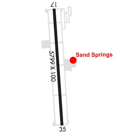
Airport Diagram might not be current.

Facility Name: WILLIAM R POGUE MUNI
City Name: SAND SPRINGS
County: OSAGE
State abbrev: OK
State Name: OKLAHOMA
   
Ownership: PUBLICLY OWNED
Use: OPEN TO THE PUBLIC
Owner's Name: CITY OF SAND SPRINGS
Address: CITY HALL, 100 E. BROADWAY
 SAND SPRINGS, OK 74063
Owner's Phone: 918-246-2500
  
Manager's Name: KEN MADISON
Address: 3200 N AIRPORT RD
 SAND SPRINGS, OK 74063
Phone: 918-246-2605; AFTER HOURS OR EMERGENCY: 918-638-6895.
   
FAA Region: SOUTHWEST
FAA Field Office: AOK


Sunrise / Sunset times for WILLIAM R POGUE MUNI

DateSunriseSunset
04/18/24 Thursday6:4620:02
04/19/24 Friday6:4520:03
04/20/24 Saturday6:4420:03
04/21/24 Sunday6:4320:04
04/22/24 Monday6:4120:05
04/23/24 Tuesday6:4020:06
04/24/24 Wednesday6:3920:07
04/25/24 Thursday6:3820:08
04/26/24 Friday6:3720:09
04/27/24 Saturday6:3520:09
04/28/24 Sunday6:3420:10
04/29/24 Monday6:3320:11
04/30/24 Tuesday6:3220:12
05/01/24 Wednesday6:3120:13

Airport Facilities

Airport Attendance ScheduleMON-SAT 0800-1700, SUN 1000-1700; ARPT UNATENDED THANKSGIVING, CHRISTMAS & NEW YEAR'S DAY. FOR ASSISTANCE AND FOR ARPT ATTENDANT AFT HRS CALL 918-638-6895.
Airport Status OPERATIONAL (This Status can change at any time - please check NOTAMS)
Airport Lighting ScheduleODALS RWY 35; PAPI RWY 17 & 35; MIRL RWY 17/35 - OPR CONSLY.
Airport Storage AvailableTie Downs
Extra Services AvailableFlight Instruction, Aircraft Rental
Wind IndicatorYES - (lighted)
Control TowerNO
CTAF Frequency122.700
Unicom Frequency122.700
Rotating Beacon ColorWG
Segmented CircleYES
Landing FeeNO

Airport Inspection Data

Airport InspectedSTATE - performed by STATE AERONAUTICAL PERSONNEL
Inspection Date12/30/2022

Airport Services

Type of Fuel AvailableGrade 100LL; -10FUEL AVBL 24 HRS WITH MAJOR CREDIT CARD.
Airframe Repair ServiceNONE
Power Plant Repair ServiceNONE

Geographic Data

LatitudeN3610.5
LongitudeW09609.1 (ESTIMATED)
Arpt Elevation892ft (SURVEYED)
Magnetic Variation06E
3 miles NWof SAND SPRINGS
Traffic Pattern Altitude
Sectional ChartKANSAS CITY

Aircraft Data

Operations (Reported)YearlyAvg. Daily
General Aviation Transient 1995055
General Aviation Local 1000027
Air Taxi 00
Commerical 00
Commuter 00
Military 500
Aircraft based on Field
General Aviation Singles 45
General Aviation Multi 2
Jet Aircraft 0
General Aviation Helicopters 1
Military Aircraft 0
Gliders 0
Ultralights 0

FAA Services

FSS on field NO
FSS tie-in MC ALESTER
FSS Phone 1-800-WX-BRIEF
Who issues Notams MLC
Notam D service at airport YES
ARTCC Name KANSAS CITY

Federal Status

Airport Certification
Aircraft Rescue & Firefighting IndexNone
Airport of EntryNo
Custom Landing RightsNo
Joint Civil/MilitaryNo
Military Landing rightsYES

Federal Agreements

NATIONAL PLAN OF INTEGRATED AIRPORT SYSTEMS (NPIAS)
GRANT AGREEMENTS UNDER FAAP/ADAP/AIP
ASSURANCES PURSUANT TO TITLE VI, CIVIL RIGHTS ACT OF 1964

Remarks

DEER INVOF ARPT.
HELICOPTER TRNG WEST TWY & WEST RAMP.
FOR CD CTC TULSA APCH AT 918-831-6714/6720.
Airport Communications & Frequencies:
CTAF Frequency:
122.700
Unicom Frequency:
122.700
TULSA Primary Approach Frequencies:  
124.0
338.3
TULSA Primary Departure Frequencies:  
124.0
338.3
Runway Identifications
Runway Identification: 17/35
Length: 5799 ft
Width: 100 ft
Surface: ASPHALT-GOOD CONDITION
Edge lights: Medium Intensity

Treatment: NONE

 Runway: 17   Runway: 35
Mag heading: 169°Mag heading: 349°
Rwy Slope: .02% UpRwy Slope: -.02% Down
Approach: Approach:
Pattern: Left Traffic; RIGHT TRAFFIC FOR HELICOPTERS.Pattern: Left Traffic
Markings: NONPRECISION INSTRUMENTMarkings: NONPRECISION INSTRUMENT
Marking Condition: GOODMarking Condition: GOOD
Arresting Dev: Arresting Dev:
Lat & Long: N3611.0  W09609.2Lat. & Long.: N3610.0  W09609.1
Elev: 889.0 ft. MSLElev: 890.1 ft. MSL
TCH: 31 ft. AGLTCH: 33 ft. AGL
Visual Glide Path: 3.00 degreesVisual Glide Path: 3.00 degrees
Displaced Threshold: NoDisplaced Threshold: No
Touchdown Zone: YESTouchdown Zone: YES
Touchdown Elev.: 889.4 feetTouchdown Elev.: 892.2 feet
Visual Glide Slope: 4-Light PAPI on LEFT side of RunwayVisual Glide Slope: 4-Light PAPI on LEFT side of Runway; PAPI UNUSBL BYD 8 DEGS LEFT, RIGHT OF RCL.
RVR Equipment: RVR Equipment:
RVV Equipment: NORVV Equipment: NO
Approach Lights: Approach Lights: ODALS - omnidirectional approach lighting system
REIL: NOREIL: NO
Centerline Lights: NOCenterline Lights: NO
Touchdown lights: NOTouchdown lights: NO
Runway Category: Runway with a Non-precision Approach having visibility minimums greater than 3/4 mileRunway Category: Runway with a Non-precision Approach having visibility minimums greater than 3/4 mile
Declared Distances: Declared Distances:
Obstructions: TREESObstructions:
Marked: NOT Marked/LightedMarked:
Clearance slope: 26:1Clearance slope: 34:1
Obstruction height: 14 feet AGLObstruction height:
Dist. from runway: 566 feetDist. from runway:
Centerline offset: 264 left of centerlineCenterline offset:
Comments: Comments:
C:2/P: