Current Weather/Notams (Metars, TAFs, Notams, NWS Forecast, PIREPS, and nearby weather)
Customs Information Send updates to Support@FltPlan.com
Customs Not Available
Database effective 05/16/2024
Airport Diagram might not be current.
|
| Facility Name: | CENTRAL MAINE/NORRIDGEWOCK |
| City Name: | NORRIDGEWOCK |
| County: | SOMERSET |
| State abbrev: | ME |
| State Name: | MAINE |
| | |
| Ownership: | PUBLICLY OWNED |
| Use: | OPEN TO THE PUBLIC |
| Owner's Name: | TOWN OF NORRIDGEWOCK |
| Address: | PO BOX 7 |
| | NORRIDGEWOCK, ME 04957 |
| Owner's Phone: | 207-634-2252 |
| | |
| Manager's Name: | RICHARD LABELLE |
| Address: | PO BOX 7; ARPT ADS: 603 AIRPORT RD. |
| | NORRIDGEWOCK, ME 04957 |
| Phone: | 207-634-2252; ADDNL CTC: ROLAND RAY 207-212-3191. |
| | |
| FAA Region: | NEW ENGLAND |
| FAA Field Office: | NONE |
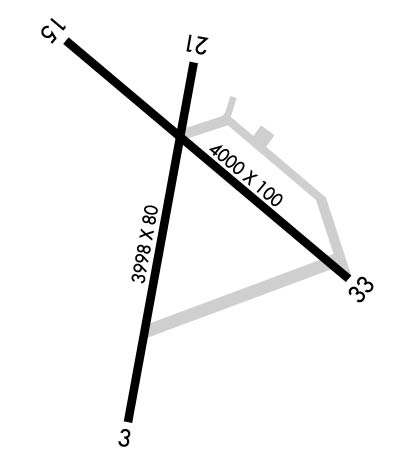
Runway Identifications
Runway Identification: 03/21Length: 3998 ft
Width: 80 ft
Surface: ASPHALT-FAIR CONDITION
Edge lights: Treatment: NONE
| | Runway: 03 | | Runway: 21 |
| Mag heading: | 28° | Mag heading: | 208° |
| Rwy Slope: | .03% Up | Rwy Slope: | -.03% Down |
| Approach: | | Approach: | |
| Pattern: | Left Traffic | Pattern: | Left Traffic |
| Markings: | NONPRECISION INSTRUMENT | Markings: | BASIC |
| Marking Condition: | POOR; MARKINGS FADED, CNTRLN MISG. | Marking Condition: | POOR; MARKINGS FADED, CNTRLN MISG. |
| Arresting Dev: | | Arresting Dev: | |
| Lat & Long: | N4442.5 W06952.1 | Lat. & Long.: | N4443.2 W06952.0 |
| Elev: | 265.0 ft. MSL | Elev: | 266.2 ft. MSL |
| TCH: | | TCH: | |
| Visual Glide Path: | | Visual Glide Path: | |
| Displaced Threshold: | No | Displaced Threshold: | No |
| Touchdown Zone: | YES | Touchdown Zone: | YES |
| Touchdown Elev.: | 268.3 feet | Touchdown Elev.: | 270.2 feet |
| Visual Glide Slope: | | Visual Glide Slope: | |
| RVR Equipment: | | RVR Equipment: | |
| RVV Equipment: | NO | RVV Equipment: | NO |
| Approach Lights: | | Approach Lights: | |
| REIL: | NO | REIL: | NO |
| Centerline Lights: | NO | Centerline Lights: | NO |
| Touchdown lights: | NO | Touchdown lights: | NO |
| Runway Category: | Runway with a Non-precision Approach | Runway Category: | Runway with a Visual Approach |
| Declared Distances: | | Declared Distances: | |
| Obstructions: | TREES | Obstructions: | TREES |
| Marked: | NOT Marked/Lighted | Marked: | NOT Marked/Lighted |
| Clearance slope: | 2:1 | Clearance slope: | 8:1 |
| Obstruction height: | 21 feet AGL | Obstruction height: | 69 feet AGL |
| Dist. from runway: | 243 feet | Dist. from runway: | 790 feet |
| Centerline offset: | 121 left of centerline | Centerline offset: | 180 feet left of centerline |
| Comments: | 10-20 FT TREES & BRUSH 0-75 FT FM THR, 240-250 FT R OF CNTRLN. | Comments: | 10-15 FT BRUSH 0-200 FT FM THR, 100-250 FT L OF CNTRLN. |
Runway Identification: 15/33Length: 4000 ft
Width: 100 ft
Surface: ASPHALT-GOOD CONDITION
Edge lights: Medium IntensityTreatment: NONE
| | Runway: 15 | | Runway: 33 |
| Mag heading: | 148° | Mag heading: | 328° |
| Rwy Slope: | -.15% Down | Rwy Slope: | .15% Up |
| Approach: | | Approach: | |
| Pattern: | Left Traffic | Pattern: | Left Traffic |
| Markings: | NONPRECISION INSTRUMENT | Markings: | BASIC |
| Marking Condition: | GOOD | Marking Condition: | GOOD |
| Arresting Dev: | | Arresting Dev: | |
| Lat & Long: | N4443.2 W06952.3 | Lat. & Long.: | N4442.8 W06951.6 |
| Elev: | 264.1 ft. MSL | Elev: | 258.3 ft. MSL |
| TCH: | 43 ft. AGL | TCH: | |
| Visual Glide Path: | 3.00 degrees | Visual Glide Path: | |
| Displaced Threshold: | No | Displaced Threshold: | No |
| Touchdown Zone: | YES | Touchdown Zone: | YES |
| Touchdown Elev.: | 269.7 feet | Touchdown Elev.: | 269.7 feet |
| Visual Glide Slope: | 2-Light PAPI on LEFT side of Runway | Visual Glide Slope: | |
| RVR Equipment: | | RVR Equipment: | |
| RVV Equipment: | NO | RVV Equipment: | NO |
| Approach Lights: | | Approach Lights: | |
| REIL: | YES | REIL: | YES |
| Centerline Lights: | NO | Centerline Lights: | NO |
| Touchdown lights: | NO | Touchdown lights: | NO |
| Runway Category: | Runway with a Non-precision Approach | Runway Category: | Runway with a Visual Approach |
| Declared Distances: | | Declared Distances: | |
| Obstructions: | TREE | Obstructions: | TREES |
| Marked: | NOT Marked/Lighted | Marked: | NOT Marked/Lighted |
| Clearance slope: | 16:1 | Clearance slope: | 1:1 |
| Obstruction height: | 35 feet AGL | Obstruction height: | 15 feet AGL |
| Dist. from runway: | 767 feet | Dist. from runway: | 215 feet |
| Centerline offset: | 285 left of centerline | Centerline offset: | 186 feet right of centerline |
| Comments: | 10 FT TREES, 10 FT FM END OF RWY, 185 FT R. | Comments: | |

