Current Weather/Notams (Metars, TAFs, Notams, NWS Forecast, PIREPS, and nearby weather)
Customs Information Send updates to Support@FltPlan.com
Customs Not Available
Database effective 05/16/2024
Airport Diagram might not be current.
|
| Facility Name: | OTTAWA MUNI |
| City Name: | OTTAWA |
| County: | FRANKLIN |
| State abbrev: | KS |
| State Name: | KANSAS |
| | |
| Ownership: | PUBLICLY OWNED |
| Use: | OPEN TO THE PUBLIC |
| Owner's Name: | CITY OF OTTAWA |
| Address: | POST OFFICE BOX 60 |
| | OTTAWA, KS 66067 |
| Owner's Phone: | 785-229-3630 |
| | |
| Manager's Name: | JIM REEDER |
| Address: | 2178 MONTANA RD |
| | OTTAWA, KS 66067 |
| Phone: | 785-242-5310 |
| | |
| FAA Region: | CENTRAL |
| FAA Field Office: | NONE |
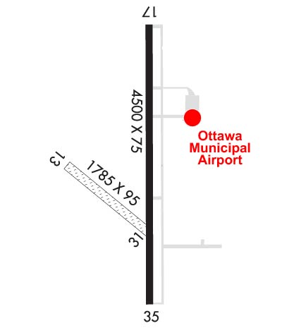
Runway Identifications
Runway Identification: 13/31Length: 1550 ft
Width: 95 ft
Surface: GRASS-GOOD CONDITION
Edge lights: Treatment: NONE
| | Runway: 13 | | Runway: 31 |
| Mag heading: | 127° | Mag heading: | 307° |
| Rwy Slope: | -.37% Down | Rwy Slope: | .37% Up |
| Approach: | | Approach: | |
| Pattern: | Right Traffic | Pattern: | Left Traffic |
| Markings: | | Markings: | |
| Marking Condition: | RWY 13/31 MKD OR DELINEATED WITH WHITE BUCKETS. | Marking Condition: | |
| Arresting Dev: | | Arresting Dev: | |
| Lat & Long: | N3832.4 W09515.5 | Lat. & Long.: | N3832.2 W09515.2 |
| Elev: | 963.1 ft. MSL | Elev: | 957.4 ft. MSL |
| TCH: | | TCH: | |
| Visual Glide Path: | | Visual Glide Path: | |
| Displaced Threshold: | No | Displaced Threshold: | No |
| Touchdown Zone: | YES | Touchdown Zone: | YES |
| Touchdown Elev.: | 963.1 feet | Touchdown Elev.: | 963.1 feet |
| Visual Glide Slope: | | Visual Glide Slope: | |
| RVR Equipment: | | RVR Equipment: | |
| RVV Equipment: | NO | RVV Equipment: | NO |
| Approach Lights: | | Approach Lights: | |
| REIL: | NO | REIL: | NO |
| Centerline Lights: | NO | Centerline Lights: | NO |
| Touchdown lights: | NO | Touchdown lights: | NO |
| Runway Category: | Runway with a Visual Approach | Runway Category: | Runway with a Visual Approach |
| Declared Distances: | | Declared Distances: | |
| Obstructions: | TREE | Obstructions: | POLE |
| Marked: | NOT Marked/Lighted | Marked: | NOT Marked/Lighted |
| Clearance slope: | 35:1 | Clearance slope: | 24:1 |
| Obstruction height: | 22 feet AGL | Obstruction height: | 44 feet AGL |
| Dist. from runway: | 778 feet | Dist. from runway: | 1089 feet |
| Centerline offset: | 21 right of centerline | Centerline offset: | 11 feet right of centerline |
| Comments: | | Comments: | |
Runway Identification: 17/35Length: 4500 ft
Width: 75 ft
Surface: CONCRETE-GOOD CONDITION
Edge lights: Medium IntensityTreatment: NONE
Weight: PCN 11 /R/C/X/U
| | Runway: 17 | | Runway: 35 |
| Mag heading: | 176° | Mag heading: | 356° |
| Rwy Slope: | -.01% Down | Rwy Slope: | .01% Up |
| Approach: | | Approach: | |
| Pattern: | Right Traffic | Pattern: | Left Traffic |
| Markings: | NONPRECISION INSTRUMENT | Markings: | NONPRECISION INSTRUMENT |
| Marking Condition: | GOOD | Marking Condition: | GOOD |
| Arresting Dev: | | Arresting Dev: | |
| Lat & Long: | N3832.7 W09515.1 | Lat. & Long.: | N3832.0 W09515.1 |
| Elev: | 964.4 ft. MSL | Elev: | 964.1 ft. MSL |
| TCH: | 26 ft. AGL | TCH: | 28 ft. AGL |
| Visual Glide Path: | 3.25 degrees | Visual Glide Path: | 3.25 degrees |
| Displaced Threshold: | No | Displaced Threshold: | No |
| Touchdown Zone: | YES | Touchdown Zone: | YES |
| Touchdown Elev.: | 964.4 feet | Touchdown Elev.: | 966.4 feet |
| Visual Glide Slope: | 2-Light PAPI on LEFT side of Runway | Visual Glide Slope: | 2-Light PAPI on LEFT side of Runway |
| RVR Equipment: | | RVR Equipment: | |
| RVV Equipment: | NO | RVV Equipment: | NO |
| Approach Lights: | | Approach Lights: | |
| REIL: | YES | REIL: | YES |
| Centerline Lights: | NO | Centerline Lights: | NO |
| Touchdown lights: | NO | Touchdown lights: | NO |
| Runway Category: | Runway with a Non-precision Approach having visibility minimums greater than 3/4 mile | Runway Category: | Runway with a Non-precision Approach having visibility minimums greater than 3/4 mile |
| Declared Distances: | | Declared Distances: | |
| Obstructions: | TREE | Obstructions: | |
| Marked: | NOT Marked/Lighted | Marked: | |
| Clearance slope: | 14:1 | Clearance slope: | 34:1 |
| Obstruction height: | 65 feet AGL | Obstruction height: | |
| Dist. from runway: | 1171 feet | Dist. from runway: | |
| Centerline offset: | 462 right of centerline | Centerline offset: | |
| Comments: | | Comments: | |