Current Weather/Notams (Metars, TAFs, Notams, NWS Forecast, PIREPS, and nearby weather)
Customs Information Send updates to Support@FltPlan.com
Customs Not Available
Database effective 05/16/2024
Airport Diagram might not be current.
|
| Facility Name: | NORWOOD MEML |
| City Name: | NORWOOD |
| County: | NORFOLK |
| State abbrev: | MA |
| State Name: | MASSACHUSETTS |
| | |
| Ownership: | PUBLICLY OWNED |
| Use: | OPEN TO THE PUBLIC |
| Owner's Name: | TOWN OF NORWOOD |
| Address: | 566 WASHINGTON ST |
| | NORWOOD, MA 02062 |
| Owner's Phone: | 781-762-1240 |
| | |
| Manager's Name: | MARK RAYMOND |
| Address: | 111 ACCESS RD |
| | NORWOOD, MA 02062 |
| Phone: | 781-255-5615 |
| | |
| FAA Region: | NEW ENGLAND |
| FAA Field Office: | NONE |
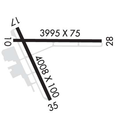
Runway Identifications
Runway Identification: 10/28Length: 3995 ft
Width: 75 ft
Surface: ASPHALT-GOOD CONDITION
Edge lights: Treatment: NONE
| | Runway: 10 | | Runway: 28 |
| Mag heading: | 104° | Mag heading: | 284° |
| Rwy Slope: | -.06% Down | Rwy Slope: | .06% Up |
| Approach: | | Approach: | |
| Pattern: | Left Traffic | Pattern: | Right Traffic; RIGHT TFC FOR TGL ONLY. |
| Markings: | BASIC | Markings: | BASIC |
| Marking Condition: | GOOD | Marking Condition: | GOOD |
| Arresting Dev: | | Arresting Dev: | |
| Lat & Long: | N4211.5 W07110.7 | Lat. & Long.: | N4211.5 W07109.8 |
| Elev: | 48.4 ft. MSL | Elev: | 46.1 ft. MSL |
| TCH: | 25 ft. AGL | TCH: | |
| Visual Glide Path: | 4.00 degrees | Visual Glide Path: | |
| Displaced Threshold: | 987 feet | Displaced Threshold: | 212 feet |
| Touchdown Zone: | YES | Touchdown Zone: | YES |
| Touchdown Elev.: | 47.8 feet | Touchdown Elev.: | 48.0 feet |
| Visual Glide Slope: | 4-Light PAPI on RIGHT side of Runway | Visual Glide Slope: | |
| RVR Equipment: | | RVR Equipment: | |
| RVV Equipment: | NO | RVV Equipment: | NO |
| Approach Lights: | | Approach Lights: | |
| REIL: | NO | REIL: | NO |
| Centerline Lights: | NO | Centerline Lights: | NO |
| Touchdown lights: | NO | Touchdown lights: | NO |
| Runway Category: | Runway with a Visual Approach | Runway Category: | Runway with a Visual Approach |
| Declared Distances: | TORA:3995' TODA:3995' ASDA:3782' LDA:2795' | Declared Distances: | TORA:3995' TODA:3995' ASDA:3808' LDA:3595' |
| Obstructions: | TREES | Obstructions: | TREES |
| Marked: | NOT Marked/Lighted | Marked: | NOT Marked/Lighted |
| Clearance slope: | 25:1; APCH RATIO 50:1 TO DTHR. | Clearance slope: | 20:1 |
| Obstruction height: | 40 feet AGL | Obstruction height: | 40 feet AGL |
| Dist. from runway: | 1200 feet | Dist. from runway: | 1000 feet |
| Centerline offset: | 125 left of centerline | Centerline offset: | 125 feet right of centerline |
| Comments: | | Comments: | |
Runway Identification: 17/35Length: 4007 ft
Width: 100 ft
Surface: ASPHALT-GOOD CONDITION
Edge lights: Medium IntensityTreatment: GROOVED
| | Runway: 17 | | Runway: 35 |
| Mag heading: | 170° | Mag heading: | 350° |
| Rwy Slope: | -.05% Down | Rwy Slope: | .05% Up |
| Approach: | | Approach: | LOC/DME |
| Pattern: | Left Traffic | Pattern: | Right Traffic; RIGHT TFC FOR TGL ONLY. |
| Markings: | NONPRECISION INSTRUMENT | Markings: | NONPRECISION INSTRUMENT |
| Marking Condition: | GOOD | Marking Condition: | GOOD |
| Arresting Dev: | | Arresting Dev: | |
| Lat & Long: | N4211.6 W07110.7 | Lat. & Long.: | N4211.0 W07110.3 |
| Elev: | 49.2 ft. MSL | Elev: | 47.1 ft. MSL |
| TCH: | 40 ft. AGL | TCH: | 40 ft. AGL |
| Visual Glide Path: | 3.00 degrees | Visual Glide Path: | 3.00 degrees |
| Displaced Threshold: | No | Displaced Threshold: | No |
| Touchdown Zone: | YES | Touchdown Zone: | YES |
| Touchdown Elev.: | 49.2 feet | Touchdown Elev.: | 48.5 feet |
| Visual Glide Slope: | 4-Light PAPI on RIGHT side of Runway | Visual Glide Slope: | 4-Light PAPI on LEFT side of Runway |
| RVR Equipment: | | RVR Equipment: | |
| RVV Equipment: | NO | RVV Equipment: | NO |
| Approach Lights: | | Approach Lights: | MALSF - 1,400 foot medium intensity approach lighting system with sequenced flashers |
| REIL: | NO | REIL: | NO |
| Centerline Lights: | NO | Centerline Lights: | NO |
| Touchdown lights: | NO | Touchdown lights: | NO |
| Runway Category: | Runway with a Visual Approach | Runway Category: | Runway with a Non-precision Approach having visibility minimums greater than 3/4 mile |
| Declared Distances: | | Declared Distances: | |
| Obstructions: | TREES | Obstructions: | Unknown |
| Marked: | NOT Marked/Lighted | Marked: | NOT Marked/Lighted |
| Clearance slope: | 25:1 | Clearance slope: | 50:1 |
| Obstruction height: | 26 feet AGL | Obstruction height: | 20 feet AGL |
| Dist. from runway: | 850 feet | Dist. from runway: | 1200 feet |
| Centerline offset: | 125 right of centerline | Centerline offset: | |
| Comments: | | Comments: | |

