KOWB

OWENSBORO-DAVIESS COUNTY
OWENSBORO
KY
Time Zone: Central
Lat: N 3744.3
Long: W 08710.0
Elev: 407
Var: +04
Longest Runway: 8000
AWOS: 124.32
Ground: 121.7
Tower: 120.7

FBO & Flight Services info for KOWB

FBOs: Update your Fuel Prices

  click here  
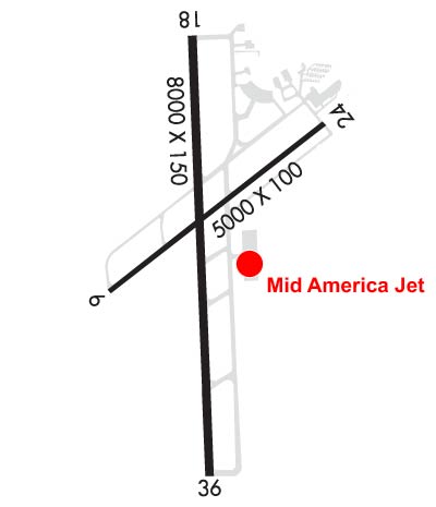
Experience MidAmerica Jet's legendary service. MidAmerica Jet provides outstanding Southern hospitality, 24 hour service, NATA Safety 1st Training, quick turns, spacious ramp and hangar facilities, fuel to government and airline contract specifications, limo and rental car arrangements, courtesy transportation, catering, hotel reservations and aircraft maintenance.
Ph: 270-926-6700 Fax: 270-926-8976 Freq: 129.05WebsiteE-Mail
                     
Service
Jet
100LL
SAF
MoGas
Fuel Avail: Open Daily 7am-7pm - Fees for after hours
Full6.757.05    Last Update: 04/10/2024 09:25

Self        
Misc. Info: Unicom frequency 129.05Address: 1 BULLFROG BLVD,   OWENSBORO, KY 42301

MODERN TRANSPORTPh: 270-685-1871 Fax: 270-685-4462 Freq: 122.95
Service
Jet
100LL
SAF
MoGas
Fuel Avail: PRIST PREMIXED. HRS.: M-F 7:30A-4:30P. 100LL self serve, 24/7. QUICK, well lighted.
Full6.49      Last Update: 04/15/2024 14:17  
Self  6.50    
 Address: 3410 BITTEL RD,   OWNESBORO, KY 42301
AWOSPh: 270-683-3228
-
Freq: 124.32  
If you are an FBO, call 1-203-262-1700 to update your info or email: FltPlan.Advertising@garmin.com
Advertise your FBO on FltPlan.com

Runway & Approach Info for KOWB
Rwy
Length
Land Dist**
Approach*
  Rwy
Length
Land Dist**
Approach*
06
5000x100  5000'          
 
  
24
  5000x100  5000'          
 
18
8000x150  8000'          
 
  
36
  8000x150  8000'          
ILS
 111.50 - 001°  
 * only ILS, LOC, LDA, and SDF approaches to a specific runway are shown
** For any Declared Landing Distance Available, please see A/FD or Approach plates
Runway Weight Capability (lbs.) Help
Runway IDSingle WheelDouble WheelDouble Tandem WheelDual Double Wheel
06/2440,00040,00040,000N/A
18/3675,000150,000200,000N/A
These numbers are Advisory and are not limits.   The Airport Manager should have more accurate Weight Limits
Approach Charts
Approaches    
Current Weather/Notams
Customs Information Send updates to Support@FltPlan.com
Customs Not Available
Database effective 04/18/2024
Airport Diagram of KOWB
Airport Diagram might not be current.

Facility Name: OWENSBORO/DAVIESS COUNTY RGNL
City Name: OWENSBORO
County: DAVIESS
State abbrev: KY
State Name: KENTUCKY
   
Ownership: PUBLICLY OWNED
Use: OPEN TO THE PUBLIC
Owner's Name: OWENSBORO CITY & DAVIESS COUNTY
Address: 2200 AIRPORT ROAD
 OWENSBORO, KY 42303
Owner's Phone: 270-685-4179
  
Manager's Name: TRISTAN DURBIN
Address: 2200 AIRPORT ROAD
 OWENSBORO, KY 42303
Phone: 270-685-4179
   
FAA Region: SOUTHERN
FAA Field Office: MEM


Sunrise / Sunset times for OWENSBORO/DAVIESS COUNTY RGNL

DateSunriseSunset
04/18/24 Thursday6:0819:28
04/19/24 Friday6:0719:29
04/20/24 Saturday6:0619:30
04/21/24 Sunday6:0419:31
04/22/24 Monday6:0319:32
04/23/24 Tuesday6:0219:32
04/24/24 Wednesday6:0119:33
04/25/24 Thursday5:5919:34
04/26/24 Friday5:5819:35
04/27/24 Saturday5:5719:36
04/28/24 Sunday5:5619:37
04/29/24 Monday5:5419:38
04/30/24 Tuesday5:5319:39
05/01/24 Wednesday5:5219:40

Airport Facilities

Airport Attendance Schedule7 Days A Week 0600-2000
Airport Status OPERATIONAL (This Status can change at any time - please check NOTAMS)
Airport Lighting ScheduleWHEN ATCT CLSD ACTVT MALSR RWY 36; REIL RWY 06, 18, 24; PAPI RWY 6, 18, 24, 36; MIRL RWY 6/24; HIRL RWY 18/36; TWY; WINDCONE - CTAF.
Airport Storage AvailableTie Downs, Hanger
Extra Services AvailableAir Freight, Charter, Flight Instruction
Wind IndicatorYES - (lighted)
Control TowerYES
CTAF Frequency120.700
Unicom Frequency122.950
Rotating Beacon ColorWG
Segmented CircleYES
Landing FeeNO

Airport Inspection Data

Airport InspectedFEDERAL - performed by FAA AIRPORTS FIELD PERSONNEL
Inspection Date06/25/2021

Airport Services

Type of Fuel AvailableGrade 100LL, JET A (freeze point -40C)
Airframe Repair ServiceMAJOR
Power Plant Repair ServiceMAJOR

Geographic Data

LatitudeN3744.3
LongitudeW08710.0 (ESTIMATED)
Arpt Elevation407ft (SURVEYED)
Magnetic Variation04W
3 miles SWof OWENSBORO
Traffic Pattern Altitude
Sectional ChartST LOUIS

Aircraft Data

Operations (Reported)YearlyAvg. Daily
General Aviation Transient 881624
General Aviation Local 581216
Air Taxi 27958
Commerical 2321
Commuter 00
Military 19265
Aircraft based on Field
General Aviation Singles 47
General Aviation Multi 8
Jet Aircraft 9
General Aviation Helicopters 0
Military Aircraft 0
Gliders 1
Ultralights 2

FAA Services

FSS on field NO
FSS tie-in LOUISVILLE
FSS Phone 1-800-WX-BRIEF
Who issues Notams OWB
Notam D service at airport YES
ARTCC Name INDIANAPOLIS

Federal Status

Airport CertificationAIRPORT RECEIVING SCHEDULED AIR CARRIER SERVICE FROM CARRIERS CERTIFICATED BY THE CIVIL AERONAUTICS BOARD; PPR 24 HR FOR UNSKED ACR OPS WITH MORE THAN 30 PAX - AMGR.
Aircraft Rescue & Firefighting IndexAIRPORT HAS A CERTIFICATE UNDER CFR PART 139
Airport of EntryNo
Custom Landing RightsNo
Joint Civil/MilitaryNo
Military Landing rightsYES

Federal Agreements

NATIONAL PLAN OF INTEGRATED AIRPORT SYSTEMS (NPIAS)
GRANT AGREEMENTS UNDER FAAP/ADAP/AIP
ASSURANCES PURSUANT TO TITLE VI, CIVIL RIGHTS ACT OF 1964

Remarks

WILDLIFE & AGRICULTURE OPS ON & INVOF ARPT.
FOR CD WHEN ATCT CLSD CTC EVANSVILLE APCH AT 812-436-4690, WHEN APCH CLSD CTC INDIANAPOLIS ARTCC AT 317-247-2411.
RWY 06/2 4 SKED ACR OPS MORE THAN 9 PAX SEATS OR UNSKED ACR OPS WITH AT LEAST 31 PAX SEATS NA.
Airport Communications & Frequencies:
OWENSBORO Tower Frequencies:   Hours(local) of operation: 0600-2200   
120.7
251.15
OWENSBORO Ground Frequencies:
121.7
Emergency Frequencies:
121.5
243.0
CTAF Frequency:
120.700
Unicom Frequency:
122.950
Remarks
  • APCH/DEP SVC PRVDD BY INDIANAPOLIS ARTCC ON FREQS 128.3/291.625 (EVANSVILLE RCAG) WHEN EVANSVILLE APCH CTL CLSD.
  • EVANSVILLE Primary Approach Frequencies:  
    124.025
    290.9
    EVANSVILLE Primary Departure Frequencies:  
    124.025
    290.9
    VFR Advisory Frequencies:
    120.7
    251.15
    Runway Identifications
    Runway Identification: 06/24
    Length: 5000 ft
    Width: 100 ft
    Surface: CONCRETE ASPHALT-FAIR CONDITION
    Edge lights: Medium Intensity

    Treatment: NONE
    Weight: PCN 17 /R/C/W/T

     Runway: 06   Runway: 24
    Mag heading: 56°Mag heading: 236°
    Rwy Slope: -.04% DownRwy Slope: .04% Up
    Approach: Approach:
    Pattern: Left TrafficPattern: Left Traffic
    Markings: NONPRECISION INSTRUMENTMarkings: NONPRECISION INSTRUMENT
    Marking Condition: GOODMarking Condition: GOOD
    Arresting Dev: Arresting Dev:
    Lat & Long: N3744.2  W08710.4Lat. & Long.: N3744.7  W08709.6
    Elev: 405.1 ft. MSLElev: 403.1 ft. MSL
    TCH: 45 ft. AGLTCH: 45 ft. AGL
    Visual Glide Path: 3.00 degreesVisual Glide Path: 3.00 degrees
    Displaced Threshold: NoDisplaced Threshold: No
    Touchdown Zone: YESTouchdown Zone: YES
    Touchdown Elev.: 405.1 feetTouchdown Elev.: 403.2 feet
    Visual Glide Slope: 2-Light PAPI on LEFT side of RunwayVisual Glide Slope: 2-Light PAPI on LEFT side of Runway
    RVR Equipment: RVR Equipment:
    RVV Equipment: NORVV Equipment: NO
    Approach Lights: Approach Lights:
    REIL: YESREIL: YES
    Centerline Lights: NOCenterline Lights: NO
    Touchdown lights: NOTouchdown lights: NO
    Runway Category: Runway with a Non-precision Approach having visibility minimums greater than 3/4 mileRunway Category: Runway with a Non-precision Approach having visibility minimums greater than 3/4 mile
    Declared Distances: TORA:5000' TODA:5000' ASDA:5000' LDA:5000'Declared Distances: TORA:5000' TODA:5000' ASDA:5000' LDA:5000'
    Runway Identification: 18/36
    Length: 8000 ft
    Width: 150 ft
    Surface: CONCRETE-GOOD CONDITION
    Edge lights: High Intensity

    Treatment: GROOVED
    Weight: PCN 37 /R/C/W/T

     Runway: 18   Runway: 36
    Mag heading: 182°Mag heading:
    Rwy Slope: -.13% DownRwy Slope: .13% Up
    Approach: Approach: ILS
    Pattern: Left TrafficPattern: Left Traffic
    Markings: PRECISION INSTRUMENTMarkings: PRECISION INSTRUMENT
    Marking Condition: GOODMarking Condition: GOOD
    Arresting Dev: Arresting Dev:
    Lat & Long: N3744.9  W08710.1Lat. & Long.: N3743.6  W08710.0
    Elev: 407.3 ft. MSLElev: 397.2 ft. MSL
    TCH: 53 ft. AGLTCH: 56 ft. AGL
    Visual Glide Path: 3.00 degreesVisual Glide Path: 3.00 degrees
    Displaced Threshold: NoDisplaced Threshold: No
    Touchdown Zone: YESTouchdown Zone: YES
    Touchdown Elev.: 407.3 feetTouchdown Elev.: 401.4 feet
    Visual Glide Slope: 4-Light PAPI on LEFT side of RunwayVisual Glide Slope: 4-Light PAPI on LEFT side of Runway
    RVR Equipment: RVR Equipment:
    RVV Equipment: NORVV Equipment: NO
    Approach Lights: Approach Lights: MALSR - 1,400 foot medium intensity approach lighting system with runway alignment indicator lights
    REIL: YESREIL: NO
    Centerline Lights: NOCenterline Lights: NO
    Touchdown lights: NOTouchdown lights: NO
    Runway Category: Runway with a Non-precision Approach having visibility minimums greater than 3/4 mileRunway Category: Precision Instrument Runway
    Declared Distances: TORA:8000' TODA:8000' ASDA:8000' LDA:8000'Declared Distances: TORA:8000' TODA:8000' ASDA:8000' LDA:8000'
    C:28/P: