Current Weather/Notams (Metars, TAFs, Notams, NWS Forecast, PIREPS, and nearby weather)
Customs Information Send updates to Support@FltPlan.com
Customs Not Available
Database effective 05/16/2024
Airport Diagram might not be current.
|
| Facility Name: | NORTH VERNON |
| City Name: | NORTH VERNON |
| County: | JENNINGS |
| State abbrev: | IN |
| State Name: | INDIANA |
| | |
| Ownership: | PUBLICLY OWNED |
| Use: | OPEN TO THE PUBLIC |
| Owner's Name: | NORTH VERNON BOAC |
| Address: | 645 E CO RD 450N |
| | NORTH VERNON, IN 47265 |
| Owner's Phone: | 812-346-5223 |
| | |
| Manager's Name: | RYAN A. CURRY |
| Address: | 645 E CO RD 450N |
| | NORTH VERNON, IN 47265 |
| Phone: | 812-346-5223 |
| | |
| FAA Region: | GREAT LAKES |
| FAA Field Office: | CHI |
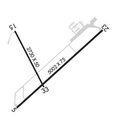
Runway Identifications
Runway Identification: 05/23Length: 5002 ft
Width: 75 ft
Surface: ASPHALT
Edge lights: Medium IntensityTreatment: NONE
| | Runway: 05 | | Runway: 23 |
| Mag heading: | 50° | Mag heading: | 230° |
| Rwy Slope: | -.05% Down | Rwy Slope: | .05% Up |
| Approach: | | Approach: | |
| Pattern: | Left Traffic | Pattern: | Left Traffic |
| Markings: | NONPRECISION INSTRUMENT | Markings: | NONPRECISION INSTRUMENT |
| Marking Condition: | GOOD | Marking Condition: | GOOD |
| Arresting Dev: | | Arresting Dev: | |
| Lat & Long: | N3902.4 W08536.6 | Lat. & Long.: | N3903.0 W08535.8 |
| Elev: | 757.2 ft. MSL | Elev: | 754.8 ft. MSL |
| TCH: | 34 ft. AGL | TCH: | 27 ft. AGL |
| Visual Glide Path: | 3.00 degrees | Visual Glide Path: | 3.00 degrees |
| Displaced Threshold: | No | Displaced Threshold: | No |
| Touchdown Zone: | YES | Touchdown Zone: | YES |
| Touchdown Elev.: | 757.2 feet | Touchdown Elev.: | 755.4 feet |
| Visual Glide Slope: | 2-Light PAPI on LEFT side of Runway | Visual Glide Slope: | 2-Light PAPI on LEFT side of Runway |
| RVR Equipment: | | RVR Equipment: | |
| RVV Equipment: | NO | RVV Equipment: | NO |
| Approach Lights: | | Approach Lights: | |
| REIL: | NO | REIL: | NO |
| Centerline Lights: | NO | Centerline Lights: | NO |
| Touchdown lights: | NO | Touchdown lights: | NO |
| Runway Category: | Runway with a Non-precision Approach having visibility minimums greater than 3/4 mile | Runway Category: | Runway with a Non-precision Approach having visibility minimums greater than 3/4 mile |
| Declared Distances: | | Declared Distances: | |
| Obstructions: | ROAD | Obstructions: | ROAD |
| Marked: | NOT Marked/Lighted | Marked: | NOT Marked/Lighted |
| Clearance slope: | 34:1 | Clearance slope: | 34:1 |
| Obstruction height: | | Obstruction height: | |
| Dist. from runway: | | Dist. from runway: | |
| Centerline offset: | | Centerline offset: | |
| Comments: | 10 FT CROPS 125 FT R OF RWY END CNTRLN. | Comments: | 10 FT CROPS 80 FT L OF RWY END CNTRLN. |
Runway Identification: 15/33Length: 2730 ft
Width: 50 ft
Surface: ASPHALT
Edge lights: Medium IntensityTreatment: NONE
| | Runway: 15 | | Runway: 33 |
| Mag heading: | 155° | Mag heading: | 335° |
| Rwy Slope: | .16% Up | Rwy Slope: | -.16% Down |
| Approach: | | Approach: | |
| Pattern: | Left Traffic | Pattern: | Left Traffic |
| Markings: | BASIC | Markings: | BASIC |
| Marking Condition: | GOOD | Marking Condition: | FAIR |
| Arresting Dev: | | Arresting Dev: | |
| Lat & Long: | N3903.0 W08536.6 | Lat. & Long.: | N3902.6 W08536.4 |
| Elev: | 751.9 ft. MSL | Elev: | 756.4 ft. MSL |
| TCH: | | TCH: | 27 ft. AGL |
| Visual Glide Path: | | Visual Glide Path: | 3.50 degrees |
| Displaced Threshold: | No | Displaced Threshold: | No |
| Touchdown Zone: | YES | Touchdown Zone: | YES |
| Touchdown Elev.: | 756.9 feet | Touchdown Elev.: | 756.9 feet |
| Visual Glide Slope: | | Visual Glide Slope: | 2-Light PAPI on LEFT side of Runway |
| RVR Equipment: | | RVR Equipment: | |
| RVV Equipment: | NO | RVV Equipment: | NO |
| Approach Lights: | | Approach Lights: | |
| REIL: | NO | REIL: | NO |
| Centerline Lights: | NO | Centerline Lights: | NO |
| Touchdown lights: | NO | Touchdown lights: | NO |
| Runway Category: | Runway with a Visual Approach | Runway Category: | Runway with a Visual Approach |
| Declared Distances: | | Declared Distances: | |
| Obstructions: | ROAD | Obstructions: | TREES |
| Marked: | NOT Marked/Lighted | Marked: | NOT Marked/Lighted |
| Clearance slope: | 12:1 | Clearance slope: | 16:1 |
| Obstruction height: | 14 feet AGL | Obstruction height: | 55 feet AGL |
| Dist. from runway: | 375 feet | Dist. from runway: | 1120 feet |
| Centerline offset: | 140 right of centerline | Centerline offset: | 205 feet right of centerline |
| Comments: | 10 FT CROPS 60 FT L OF RWY END CNTRLN. | Comments: | 10 FT CROPS 60 FT L & R OF RWY END CNTRLN. |

