Current Weather/Notams (Metars, TAFs, Notams, NWS Forecast, PIREPS, and nearby weather)
Customs Information Send updates to Support@FltPlan.com
Customs Not Available
Database effective 05/16/2024
Airport Diagram might not be current. Facility Name: UNIVERSITY OF OKLAHOMA WESTHEIMER City Name: NORMAN County: CLEVELAND State abbrev: OK State Name: OKLAHOMA Ownership: PUBLICLY OWNED Use: OPEN TO THE PUBLIC Owner's Name: UNIV OF OKLAHOMA Address: 1700 LEXINGTON AVE NORMAN, OK 73069 Owner's Phone: 405-325-7233 Manager's Name: LANCE LAMKIN Address: 1700 LEXINGTON AVE, SUITE 212 NORMAN, OK 73069 Phone: 405-325-7233 FAA Region: SOUTHWEST FAA Field Office: AOK
Runway Identifications Help
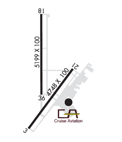
Runway Identification: 03/21 Length: 4748 ftWidth: 100 ftSurface: ASPHALT-GOOD CONDITIONEdge lights: Medium Intensity Treatment: NONE Runway: 03 Runway: 21 Mag heading: 33° Mag heading: 213° Rwy Slope: .08% Up Rwy Slope: -.08% Down Approach: LOC/DME Approach: Pattern: Left Traffic Pattern: Right Traffic Markings: NONPRECISION INSTRUMENT Markings: NONPRECISION INSTRUMENT Marking Condition: GOOD Marking Condition: GOOD Arresting Dev: Arresting Dev: Lat & Long: N3514.2 W09728.5 Lat. & Long.: N3514.8 W09728.0 Elev: 1175.2 ft. MSL Elev: 1179.1 ft. MSL TCH: 40 ft. AGL TCH: 40 ft. AGL Visual Glide Path: 3.00 degrees Visual Glide Path: 3.00 degrees Displaced Threshold: No Displaced Threshold: No Touchdown Zone: YES Touchdown Zone: YES Touchdown Elev.: 1177.4 feet Touchdown Elev.: 1179.2 feet Visual Glide Slope: 4-Light PAPI on LEFT side of Runway Visual Glide Slope: 4-Light PAPI on LEFT side of Runway RVR Equipment: RVR Equipment: RVV Equipment: NO RVV Equipment: NO Approach Lights: MALS - 1,400 foot medium intensity approach lighting system Approach Lights: REIL: NO REIL: NO Centerline Lights: NO Centerline Lights: NO Touchdown lights: NO Touchdown lights: NO Runway Category: D Runway Category: Runway with a Visual Approach Declared Distances: Declared Distances:
Runway Identification: 18/36 Length: 5199 ftWidth: 100 ftSurface: ASPHALT-GOOD CONDITIONEdge lights: Medium Intensity Treatment: GROOVED Runway: 18 Runway: 36 Mag heading: 177° Mag heading: 357° Rwy Slope: -.08% Down Rwy Slope: .08% Up Approach: ILS/DME Approach: Pattern: Right Traffic Pattern: Left Traffic Markings: PRECISION INSTRUMENT Markings: NONPRECISION INSTRUMENT Marking Condition: GOOD Marking Condition: GOOD Arresting Dev: Arresting Dev: Lat & Long: N3515.4 W09728.4 Lat. & Long.: N3514.5 W09728.4 Elev: 1181.6 ft. MSL Elev: 1177.2 ft. MSL TCH: 55 ft. AGL TCH: 40 ft. AGL Visual Glide Path: 3.00 degrees Visual Glide Path: 3.00 degrees Displaced Threshold: No Displaced Threshold: No Touchdown Zone: YES Touchdown Zone: YES Touchdown Elev.: 1181.7 feet Touchdown Elev.: 1181.6 feet Visual Glide Slope: 4-Light PAPI on LEFT side of Runway Visual Glide Slope: 4-Light PAPI on LEFT side of Runway RVR Equipment: RVR Equipment: RVV Equipment: NO RVV Equipment: NO Approach Lights: MALSR - 1,400 foot medium intensity approach lighting system with runway alignment indicator lights Approach Lights: REIL: NO REIL: YES Centerline Lights: NO Centerline Lights: NO Touchdown lights: NO Touchdown lights: NO Runway Category: Precision Instrument Runway Runway Category: Runway with a Non-precision Approach having visibility minimums greater than 3/4 mile Declared Distances: Declared Distances: