Current Weather/Notams (Metars, TAFs, Notams, NWS Forecast, PIREPS, and nearby weather)
Customs Information Send updates to Support@FltPlan.com
Customs Not Available
Database effective 05/16/2024
Airport Diagram might not be current.
|
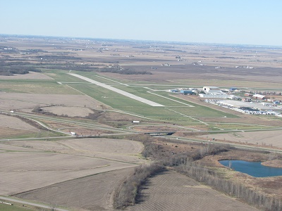
| Facility Name: | OTTUMWA RGNL |
| City Name: | OTTUMWA |
| County: | WAPELLO |
| State abbrev: | IA |
| State Name: | IOWA |
| | |
| Ownership: | PUBLICLY OWNED |
| Use: | OPEN TO THE PUBLIC |
| Owner's Name: | CITY OF OTTUMWA |
| Address: | CITY HALL |
| | OTTUMWA, IA 52501 |
| Owner's Phone: | 641-683-0619 |
| | |
| Manager's Name: | JAY WHEATON |
| Address: | 14802 TERMINAL ST |
| | OTTUMWA, IA 52501 |
| Phone: | 641-683-0619 |
| | |
| FAA Region: | CENTRAL |
| FAA Field Office: | NONE |
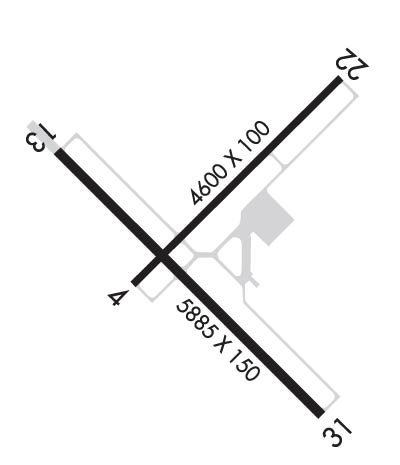
Runway Identifications
Runway Identification: 04/22Length: 4601 ft
Width: 100 ft
Surface: CONCRETE ASPHALT-GOOD CONDITION
Edge lights: High IntensityTreatment: NONE
Weight: PCN 13 /F/D/X/U
| | Runway: 04 | | Runway: 22 |
| Mag heading: | 46° | Mag heading: | 226° |
| Rwy Slope: | -.19% Down | Rwy Slope: | .19% Up |
| Approach: | | Approach: | |
| Pattern: | Left Traffic | Pattern: | Left Traffic |
| Markings: | NONPRECISION INSTRUMENT | Markings: | NONPRECISION INSTRUMENT |
| Marking Condition: | GOOD | Marking Condition: | GOOD |
| Arresting Dev: | | Arresting Dev: | |
| Lat & Long: | N4106.3 W09227.1 | Lat. & Long.: | N4106.8 W09226.4 |
| Elev: | 841.4 ft. MSL | Elev: | 832.7 ft. MSL |
| TCH: | 40 ft. AGL | TCH: | 41 ft. AGL |
| Visual Glide Path: | 3.00 degrees | Visual Glide Path: | 3.00 degrees |
| Displaced Threshold: | No | Displaced Threshold: | No |
| Touchdown Zone: | YES | Touchdown Zone: | YES |
| Touchdown Elev.: | 845.6 feet | Touchdown Elev.: | 845.6 feet |
| Visual Glide Slope: | 2-Light PAPI on LEFT side of Runway | Visual Glide Slope: | 2-Light PAPI on LEFT side of Runway |
| RVR Equipment: | | RVR Equipment: | |
| RVV Equipment: | NO | RVV Equipment: | NO |
| Approach Lights: | | Approach Lights: | |
| REIL: | YES | REIL: | YES |
| Centerline Lights: | NO | Centerline Lights: | NO |
| Touchdown lights: | NO | Touchdown lights: | NO |
| Runway Category: | Runway with a Visual Approach | Runway Category: | Runway with a Visual Approach |
| Declared Distances: | | Declared Distances: | |
Runway Identification: 13/31Length: 6001 ft
Width: 100 ft
Surface: CONCRETE
Edge lights: High IntensityTreatment: GROOVED
Weight: PCN 33 /R/D/W/U
| | Runway: 13 | | Runway: 31 |
| Mag heading: | 136° | Mag heading: | 316° |
| Rwy Slope: | -.03% Down | Rwy Slope: | .03% Up |
| Approach: | | Approach: | ILS |
| Pattern: | Left Traffic | Pattern: | Left Traffic |
| Markings: | PRECISION INSTRUMENT | Markings: | PRECISION INSTRUMENT |
| Marking Condition: | GOOD | Marking Condition: | GOOD |
| Arresting Dev: | | Arresting Dev: | |
| Lat & Long: | N4106.7 W09227.4 | Lat. & Long.: | N4106.0 W09226.4 |
| Elev: | 840.0 ft. MSL | Elev: | 838.4 ft. MSL |
| TCH: | 40 ft. AGL | TCH: | |
| Visual Glide Path: | 3.00 degrees | Visual Glide Path: | |
| Displaced Threshold: | No | Displaced Threshold: | No |
| Touchdown Zone: | YES | Touchdown Zone: | YES |
| Touchdown Elev.: | 842.2 feet | Touchdown Elev.: | 842.2 feet |
| Visual Glide Slope: | 4-Light PAPI on LEFT side of Runway | Visual Glide Slope: | |
| RVR Equipment: | | RVR Equipment: | |
| RVV Equipment: | NO | RVV Equipment: | NO |
| Approach Lights: | | Approach Lights: | MALSR - 1,400 foot medium intensity approach lighting system with runway alignment indicator lights |
| REIL: | YES | REIL: | NO |
| Centerline Lights: | NO | Centerline Lights: | NO |
| Touchdown lights: | NO | Touchdown lights: | NO |
| Runway Category: | D | Runway Category: | Precision Instrument Runway |
| Declared Distances: | | Declared Distances: | |