Current Weather/Notams (Metars, TAFs, Notams, NWS Forecast, PIREPS, and nearby weather)
Customs Information Send updates to Support@FltPlan.com
Customs Not Available
Database effective 04/18/2024
Airport Diagram might not be current.
|
| Facility Name: | WORTHINGTON MUNI |
| City Name: | WORTHINGTON |
| County: | NOBLES |
| State abbrev: | MN |
| State Name: | MINNESOTA |
| | |
| Ownership: | PUBLICLY OWNED |
| Use: | OPEN TO THE PUBLIC |
| Owner's Name: | CITY OF WORTHINGTON |
| Address: | 303 NINTH ST., BOX 279 |
| | WORTHINGTON, MN 56187-2335 |
| Owner's Phone: | 507-372-8600 |
| | |
| Manager's Name: | TODD WIETZEMA; CAMERON JOHNSON - 507-376-9293. |
| Address: | 303 NINTH ST., BOX 279 |
| | WORTHINGTON, MN 56817-0279 |
| Phone: | 507-372-8650 |
| | |
| FAA Region: | GREAT LAKES |
| FAA Field Office: | DMA |
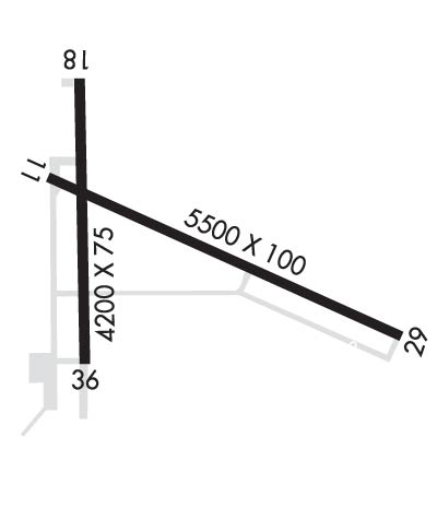
Runway Identifications
Runway Identification: 11/29Length: 5500 ft
Width: 100 ft
Surface: ASPHALT-GOOD CONDITION
Edge lights: High IntensityTreatment: GROOVED
| | Runway: 11 | | Runway: 29 |
| Mag heading: | 113° | Mag heading: | 293° |
| Rwy Slope: | -.13% Down | Rwy Slope: | .13% Up |
| Approach: | | Approach: | ILS |
| Pattern: | Left Traffic | Pattern: | Left Traffic |
| Markings: | NONPRECISION INSTRUMENT | Markings: | PRECISION INSTRUMENT |
| Marking Condition: | GOOD | Marking Condition: | GOOD |
| Arresting Dev: | | Arresting Dev: | |
| Lat & Long: | N4339.5 W09535.1 | Lat. & Long.: | N4339.1 W09534.0 |
| Elev: | 1573.5 ft. MSL | Elev: | 1566.4 ft. MSL |
| TCH: | 42 ft. AGL | TCH: | 43 ft. AGL |
| Visual Glide Path: | 3.00 degrees | Visual Glide Path: | 3.00 degrees |
| Displaced Threshold: | No | Displaced Threshold: | No |
| Touchdown Zone: | YES | Touchdown Zone: | YES |
| Touchdown Elev.: | 1574.0 feet | Touchdown Elev.: | 1570.4 feet |
| Visual Glide Slope: | 4-Light PAPI on LEFT side of Runway | Visual Glide Slope: | 4-Light PAPI on LEFT side of Runway |
| RVR Equipment: | | RVR Equipment: | |
| RVV Equipment: | NO | RVV Equipment: | NO |
| Approach Lights: | | Approach Lights: | MALSR - 1,400 foot medium intensity approach lighting system with runway alignment indicator lights |
| REIL: | YES | REIL: | NO |
| Centerline Lights: | NO | Centerline Lights: | NO |
| Touchdown lights: | NO | Touchdown lights: | NO |
| Runway Category: | D | Runway Category: | Precision Instrument Runway |
| Declared Distances: | | Declared Distances: | |
Runway Identification: 18/36Length: 4200 ft
Width: 75 ft
Surface: ASPHALT-GOOD CONDITION
Edge lights: Medium IntensityTreatment: GROOVED
| | Runway: 18 | | Runway: 36 |
| Mag heading: | 178° | Mag heading: | 358° |
| Rwy Slope: | .06% Up | Rwy Slope: | -.06% Down |
| Approach: | | Approach: | |
| Pattern: | Left Traffic | Pattern: | Left Traffic |
| Markings: | NONPRECISION INSTRUMENT | Markings: | NONPRECISION INSTRUMENT |
| Marking Condition: | GOOD | Marking Condition: | GOOD |
| Arresting Dev: | | Arresting Dev: | |
| Lat & Long: | N4339.7 W09535.0 | Lat. & Long.: | N4339.0 W09535.0 |
| Elev: | 1571.4 ft. MSL | Elev: | 1573.9 ft. MSL |
| TCH: | 30 ft. AGL | TCH: | 30 ft. AGL |
| Visual Glide Path: | 3.00 degrees | Visual Glide Path: | 3.00 degrees |
| Displaced Threshold: | No | Displaced Threshold: | No |
| Touchdown Zone: | YES | Touchdown Zone: | YES |
| Touchdown Elev.: | 1573.6 feet | Touchdown Elev.: | 1574.0 feet |
| Visual Glide Slope: | 4-Light PAPI on LEFT side of Runway | Visual Glide Slope: | 4-Light PAPI on LEFT side of Runway |
| RVR Equipment: | | RVR Equipment: | |
| RVV Equipment: | NO | RVV Equipment: | NO |
| Approach Lights: | | Approach Lights: | |
| REIL: | YES | REIL: | YES |
| Centerline Lights: | NO | Centerline Lights: | NO |
| Touchdown lights: | NO | Touchdown lights: | NO |
| Runway Category: | Runway with a Non-precision Approach having visibility minimums greater than 3/4 mile | Runway Category: | Runway with a Non-precision Approach having visibility minimums greater than 3/4 mile |
| Declared Distances: | | Declared Distances: | |


