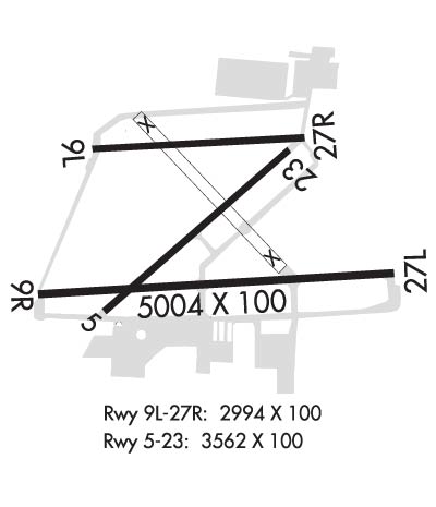
Runway Identification: 05/23Length: 3562 ft
Width: 100 ft
Surface: ASPHALT-GOOD CONDITION
Edge lights: Treatment: NONE
Weight: PCN 12 /F/B/X/T
| | Runway: 05 | | Runway: 23 |
| Mag heading: | 54° | Mag heading: | 234° |
| Rwy Slope: | -.29% Down | Rwy Slope: | .29% Up |
| Approach: | | Approach: | |
| Pattern: | Left Traffic | Pattern: | Left Traffic |
| Markings: | BASIC | Markings: | BASIC |
| Marking Condition: | GOOD | Marking Condition: | GOOD |
| Arresting Dev: | | Arresting Dev: | |
| Lat & Long: | N4004.6 W08304.7 | Lat. & Long.: | N4005.0 W08304.1 |
| Elev: | 903.1 ft. MSL | Elev: | 892.7 ft. MSL |
| TCH: | | TCH: | |
| Visual Glide Path: | | Visual Glide Path: | |
| Displaced Threshold: | No | Displaced Threshold: | No |
| Touchdown Zone: | YES | Touchdown Zone: | YES |
| Touchdown Elev.: | 905.5 feet | Touchdown Elev.: | 905.4 feet |
| Visual Glide Slope: | | Visual Glide Slope: | |
| RVR Equipment: | | RVR Equipment: | |
| RVV Equipment: | NO | RVV Equipment: | NO |
| Approach Lights: | | Approach Lights: | |
| REIL: | NO | REIL: | NO |
| Centerline Lights: | NO | Centerline Lights: | NO |
| Touchdown lights: | NO | Touchdown lights: | NO |
| Runway Category: | Runway with a Visual Approach | Runway Category: | Runway with a Visual Approach |
| Declared Distances: | TORA:3562' TODA:3562' ASDA:3562' LDA:3562' | Declared Distances: | TORA:3562' TODA:3562' ASDA:3562' LDA:3562' |
| Obstructions: | TREES | Obstructions: | TREES |
| Marked: | NOT Marked/Lighted | Marked: | NOT Marked/Lighted |
| Clearance slope: | 15:1 | Clearance slope: | 20:1 |
| Obstruction height: | 37 feet AGL | Obstruction height: | 60 feet AGL |
| Dist. from runway: | 780 feet | Dist. from runway: | 1422 feet |
| Centerline offset: | 200 right of centerline | Centerline offset: | 50 feet right of centerline |
| Comments: | | Comments: | |
Runway Identification: 09L/27RLength: 2994 ft
Width: 100 ft
Surface: ASPHALT-FAIR CONDITION
Edge lights: Medium IntensityTreatment: NONE
Weight: PCN 5 /F/B/X/T
| | Runway: 09L | | Runway: 27R |
| Mag heading: | 92° | Mag heading: | 272° |
| Rwy Slope: | -.43% Down | Rwy Slope: | .43% Up |
| Approach: | | Approach: | |
| Pattern: | Left Traffic | Pattern: | Left Traffic |
| Markings: | BASIC | Markings: | BASIC |
| Marking Condition: | GOOD | Marking Condition: | GOOD |
| Arresting Dev: | | Arresting Dev: | |
| Lat & Long: | N4005.0 W08304.7 | Lat. & Long.: | N4005.0 W08304.1 |
| Elev: | 904.3 ft. MSL | Elev: | 891.5 ft. MSL |
| TCH: | 27 ft. AGL | TCH: | 31 ft. AGL |
| Visual Glide Path: | 3.00 degrees | Visual Glide Path: | 3.00 degrees |
| Displaced Threshold: | No | Displaced Threshold: | No |
| Touchdown Zone: | YES | Touchdown Zone: | YES |
| Touchdown Elev.: | 904.6 feet | Touchdown Elev.: | 904.6 feet |
| Visual Glide Slope: | 2-Box VASI on LEFT side of Runway | Visual Glide Slope: | 2-Box VASI on LEFT side of Runway |
| RVR Equipment: | | RVR Equipment: | |
| RVV Equipment: | NO | RVV Equipment: | NO |
| Approach Lights: | | Approach Lights: | |
| REIL: | NO | REIL: | NO |
| Centerline Lights: | NO | Centerline Lights: | NO |
| Touchdown lights: | NO | Touchdown lights: | NO |
| Runway Category: | Runway with a Visual Approach | Runway Category: | Runway with a Visual Approach |
| Declared Distances: | TORA:2994' TODA:2994' ASDA:2994' LDA:2994' | Declared Distances: | TORA:2994' TODA:2994' ASDA:2994' LDA:2994' |
| Obstructions: | Unknown | Obstructions: | TREES |
| Marked: | NOT Marked/Lighted | Marked: | NOT Marked/Lighted |
| Clearance slope: | 35:1 | Clearance slope: | 18:1 |
| Obstruction height: | 67 feet AGL | Obstruction height: | 72 feet AGL |
| Dist. from runway: | 2550 feet | Dist. from runway: | 1545 feet |
| Centerline offset: | 125 right of centerline | Centerline offset: | 122 feet right of centerline |
| Comments: | | Comments: | |
Runway Identification: 09R/27LLength: 5004 ft
Width: 100 ft
Surface: ASPHALT-GOOD CONDITION
Edge lights: High IntensityTreatment: GROOVED
Weight: PCN 17 /F/B/X/T
| | Runway: 09R | | Runway: 27L |
| Mag heading: | 92° | Mag heading: | 272° |
| Rwy Slope: | -.23% Down | Rwy Slope: | .23% Up |
| Approach: | ILS | Approach: | |
| Pattern: | Left Traffic | Pattern: | Left Traffic |
| Markings: | PRECISION INSTRUMENT | Markings: | NONPRECISION INSTRUMENT |
| Marking Condition: | GOOD | Marking Condition: | GOOD |
| Arresting Dev: | | Arresting Dev: | |
| Lat & Long: | N4004.6 W08304.9 | Lat. & Long.: | N4004.7 W08303.8 |
| Elev: | 901.3 ft. MSL | Elev: | 889.6 ft. MSL |
| TCH: | 51 ft. AGL | TCH: | 28 ft. AGL |
| Visual Glide Path: | 3.00 degrees | Visual Glide Path: | 3.00 degrees |
| Displaced Threshold: | No | Displaced Threshold: | No |
| Touchdown Zone: | YES | Touchdown Zone: | YES |
| Touchdown Elev.: | 905.5 feet | Touchdown Elev.: | 902.8 feet |
| Visual Glide Slope: | 4-Light PAPI on LEFT side of Runway | Visual Glide Slope: | 4-Light PAPI on LEFT side of Runway |
| RVR Equipment: | | RVR Equipment: | |
| RVV Equipment: | NO | RVV Equipment: | NO |
| Approach Lights: | MALSR - 1,400 foot medium intensity approach lighting system with runway alignment indicator lights | Approach Lights: | |
| REIL: | NO | REIL: | YES |
| Centerline Lights: | NO | Centerline Lights: | NO |
| Touchdown lights: | NO | Touchdown lights: | NO |
| Runway Category: | Precision Instrument Runway | Runway Category: | Runway with a Non-precision Approach having visibility minimums greater than 3/4 mile |
| Declared Distances: | TORA:5004' TODA:5004' ASDA:5004' LDA:5004' | Declared Distances: | TORA:5004' TODA:5004' ASDA:5004' LDA:5004' |
| Obstructions: | Unknown | Obstructions: | TREE |
| Marked: | NOT Marked/Lighted | Marked: | NOT Marked/Lighted |
| Clearance slope: | 35:1 | Clearance slope: | 42:1 |
| Obstruction height: | 1646 feet AGL | Obstruction height: | 53 feet AGL |
| Dist. from runway: | 1696 feet | Dist. from runway: | 2470 feet |
| Centerline offset: | 612 left of centerline | Centerline offset: | 714 feet right of centerline |
| Comments: | | Comments: | |
Runway Identification: H1 HELIPADLength: 40 ft
Width: 40 ft
Surface: ASPHALT-GOOD CONDITION
Edge lights:
Treatment: NONE