Click here for more info on on SMS!

KORL

EXECUTIVE
ORLANDO
FL
Time Zone: Eastern
Lat: N 2832.7
Long: W 08120.0
Elev: 113
Var: +06
Longest Runway: 6004
Clr Del: 128.45
Dept. ATIS: 127.25
Arr. ATIS: 127.25
AWOS: 127.25
Ground: 121.4
Tower: 118.7

FBO & Flight Services info for KORL

FBOs: Update your Fuel Prices

  click here  
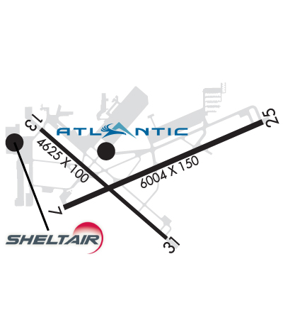
Atlantic Aviation is your premier aviation service provider with more than 100 locations in North America, including Hawaii and the Caribbean. We provide standard ground services you'd expect, with a detailed focus on ensuring an unforgettable customer experience.
Ph: 407-894-7331 Fax: 407-894-5094 Freq: 122.95WebsiteE-Mail
                               
Service
Jet
100LL
SAF
MoGas
Fuel Avail: 0600-2200, After hours fee may apply 2200-0600
Full7.488.98    Last Update: 04/25/2024 13:10:33

Self        
Misc. Info: Philips Into-Plane accepted, various contract fuel programs are acceptedAddress: 400 HERNDON AVE,   ORLANDO, FL 32803

  click here  
Enjoy VIP services and amenities in the heart of Florida and just blocks from Orlando's downtown business center, including new hangars and a new executive terminal, self-serve avgas, superior ground support and concierge services, complimentary interior cleaning, catering, crew cars, canteen market and complimentary refreshments, executive conference rooms, and a well-appointed pilot lounge.
Ph: 407-392-0440 Fax: 407-581-5652 Freq: 131.6WebsiteE-Mail
                     
Service
Jet
100LL
SAF
MoGas
Fuel Avail: Hours: 0600-2200
Full7.098.77    Last Update: 04/23/2024 08:41
PRICES GUARANTEED by FBO.
Self  6.40    
Misc. Info: Call us for special fuel pricing!Address: 3051 EAST LIVINGSTON STREET   ORLANDO, FL 32803

ASOSPh: 407-658-6753
-
-
 
If you are an FBO, call 1-203-262-1700 to update your info or email: FltPlan.Advertising@garmin.com
Advertise your FBO on FltPlan.com

Runway & Approach Info for KORL
Rwy
Length
Land Dist**
Approach*
  Rwy
Length
Land Dist**
Approach*
07
6004x150  6004'          
ILS
 109.90 - 072°  
  
25
  6004x150  6004'          
ILS/DME
 109.35 - 252°  
13
4625x100  4625'          
 
  
31
  4625x100  4625'          
 
 * only ILS, LOC, LDA, and SDF approaches to a specific runway are shown
** For any Declared Landing Distance Available, please see A/FD or Approach plates
Runway Weight Capability (lbs.) Help
Runway IDSingle WheelDouble WheelDouble Tandem WheelDual Double Wheel
07/2545,000100,000115,000N/A
13/3135,00060,000N/AN/A
These numbers are Advisory and are not limits.   The Airport Manager should have more accurate Weight Limits
Approach Charts
Approaches    
Current Weather/Notams
Customs Information Send updates to Support@FltPlan.com
Phone 407-825-5102
Fax 407-897-5118

Comments 8:30 AM-5:00 PM(Eastern) Weekdays (Monday-Friday) * Fee is charged for the use of CBP services.
Database effective 05/16/2024
Airport Diagram of KORL
Airport Diagram might not be current.

Facility Name: EXEC
City Name: ORLANDO
County: ORANGE
State abbrev: FL
State Name: FLORIDA
   
Ownership: PUBLICLY OWNED
Use: OPEN TO THE PUBLIC
Owner's Name: GREATER ORLANDO AVIATION AUTH; ARPT MAIN OFC CTC 407-825-1699; 24/7 EMERG CTC 407 579-5088.
Address: 1 JEFF FUQUA BLVD
 ORLANDO, FL 32827-4399
Owner's Phone: 407-825-1699
  
Manager's Name: JUDITH-ANN JARRETTE
Address: 365 RICKENBACKER DR
 ORLANDO, FL 32803
Phone: 407-825-1683
   
FAA Region: SOUTHERN
FAA Field Office: ORL
93NBAA 200694 by David Cullens Flying Fotos, Inc.


Click here for full scale & interactive Sectional view of KORL


Sunrise / Sunset times for EXEC

DateSunriseSunset
04/24/24 Wednesday6:5019:57
04/25/24 Thursday6:4919:57
04/26/24 Friday6:4819:58
04/27/24 Saturday6:4719:59
04/28/24 Sunday6:4719:59
04/29/24 Monday6:4620:00
04/30/24 Tuesday6:4520:00
05/01/24 Wednesday6:4420:01
05/02/24 Thursday6:4320:02
05/03/24 Friday6:4220:02
05/04/24 Saturday6:4220:03
05/05/24 Sunday6:4120:03
05/06/24 Monday6:4020:04
05/07/24 Tuesday6:3920:05

Airport Facilities

Airport Attendance ScheduleCONTINUOUS
Airport Status OPERATIONAL (This Status can change at any time - please check NOTAMS)
Airport Lighting ScheduleWHEN ATCT CLSD ACTVT MALSR RWY 07; REIL RWY 13 & 31; HIRL RWY 07/25 & 13/31; TWY LGTS - CTAF.
Airport Storage AvailableTie Downs, Hanger
Extra Services AvailableAir Freight, Air Ambulance, Avionics, Cargo Handling, Charter, Flight Instruction, Aircraft Rental, Aircraft Sales, Annual Surveying
Wind IndicatorYES - (lighted)
Control TowerYES
CTAF Frequency118.700
Unicom Frequency122.950
Rotating Beacon ColorWG
Segmented CircleNO
Landing FeeNO

Airport Inspection Data

Airport InspectedSTATE - performed by STATE AERONAUTICAL PERSONNEL
Inspection Date08/17/2018

Airport Services

Type of Fuel AvailableGrade 100, Grade 100LL, JET A (freeze point -40C)
Airframe Repair ServiceMAJOR
Power Plant Repair ServiceMAJOR

Geographic Data

LatitudeN2832.7
LongitudeW08120.0 (ESTIMATED)
Arpt Elevation112ft (SURVEYED)
Magnetic Variation06W
3 miles Eof ORLANDO
Traffic Pattern Altitude
Sectional ChartJACKSONVILLE

Aircraft Data

Operations (Reported)YearlyAvg. Daily
General Aviation Transient 72575199
General Aviation Local 76159209
Air Taxi 841023
Commerical 120
Commuter 00
Military 00
Aircraft based on Field
General Aviation Singles 155
General Aviation Multi 47
Jet Aircraft 36
General Aviation Helicopters 19
Military Aircraft 0
Gliders 1
Ultralights 1

FAA Services

FSS on field NO
FSS tie-in SAINT PETERSBURG
FSS Phone 1-800-WX-BRIEF
Who issues Notams ORL
Notam D service at airport YES
ARTCC Name JACKSONVILLE

Federal Status

Airport Certification
Aircraft Rescue & Firefighting IndexTWY E BTW TWY E5 & E6 IS NON MOVEMENT AREA. ARFF ON FIELD; NO INDEX.
Airport of EntryNo
Custom Landing RightsNo; US CUSTOMS USER FEE ARPT.
Joint Civil/MilitaryNo
Military Landing rightsYES

Federal Agreements

NATIONAL PLAN OF INTEGRATED AIRPORT SYSTEMS (NPIAS)
GRANT AGREEMENTS UNDER FAAP/ADAP/AIP
SURPLUS PROPERTY AGREEMENT UNDER PUBLIC LAW 289
CONVEYANCE UNDER SCETION 16, FEDERAL AIRPORT ACT OF 1946 OR SECTION 23, AIRPORT AND AIRWAY DEVELOPMENT ACT OF 1970
ASSURANCES PURSUANT TO TITLE VI, CIVIL RIGHTS ACT OF 1964

Remarks

PPR FOR ACFT OVER 100000 LBS; CTC AMGR 407-825-1683.
CBP OFC LCTD ONSITE PPR. CTC 407 825-5102. BE ALERT: CBP BOX LCTD ON EAST RAMP IS RSTRD.
EXECUTIVE ARPT VFR ARR/DEP EXERCISE CAUTION DUE TO SMALL & HVY TURBO-JET ACFT TRANSITING ARPT TFC AREA 2000 FT & ABOVE ON APCH TO ORLANDO INTL 5.6 NM S.
TWY E BTW TWY E5 & E6 IS NON MOVEMENT AREA. ARFF ON FIELD; NO INDEX.
CALL BOXES MKD NEAR ENTRANCES TO W, N & E RAMPS.
LGTD BRIDGE HWY LCTD 0.5 NM S OF ARPT MAY GIVE FALSE INDCN OF APCH TO RWY 07 & 31.
WILDLIFE INVOF ARPT.
FOR CD OR TO CNL IFR WHEN ATCT IS CLSD, CTC ORLANDO APCH AT 407-852-7500.
NOISE SENSITIVE ARPT. WHEN ATCT CLSD RWY 07 IS PREF NOISE ABATEMENT RWY WX PMTG. VOLUNTARY RESTRAINT FROM TGL OPS 2300 - 0700.
BANNER TOWING OPS S RWY 07/25.
ACFT TAXI ON S HALF OF THE W RAMP RESTR TO ADG1.
ATC RADAR REQ WHEN ORL ILS RWY 7 & MCO ILS RWY 17 & 18R SIMULTANEOUS OPS ARE CONDUCTED.
Airport Communications & Frequencies:
ATIS Frequencies:   Hours(local) of Operation: CONTINUOUS
127.25
EXECUTIVE Tower Frequencies:   Hours(local) of operation: 0700-2200   
118.7
239.0
EXECUTIVE Ground Frequencies:
121.4
239.0
Clearance Delivery Frequencies:
128.45
Emergency Frequencies:
121.5
243.0
CTAF Frequency:
118.700
Unicom Frequency:
122.950
ORLANDO Primary Approach Frequencies:  
119.4 181-310 5500 FT & BLW
119.4 SOUTHWEST
119.775 061-180 4500 FT & BLW
120.15 181-359 ABV 5500 FT
124.8 000-180 ABV 5000 FT
135.3 311-060 5500 FT & BLW
351.9 5500 FT & BLW
ORLANDO Primary Departure Frequencies:  
119.4 181-310 5500 FT & BLW
119.4 SOUTHWEST
119.775 061-180 4500 FT & BLW
120.15 181-359 ABV 5500 FT
124.8 000-180 ABV 5000 FT
135.3 311-060 5500 FT & BLW
351.9 5500 FT & BLW
Runway Identifications
Runway Identification: 07/25
Length: 6004 ft
Width: 150 ft
Surface: ASPHALT-FAIR CONDITION
Edge lights: High Intensity

Treatment: GROOVED
Weight: PCN 55 /F/A/W/T

 Runway: 07   Runway: 25
Mag heading: 73°Mag heading: 253°
Rwy Slope: .07% UpRwy Slope: -.07% Down
Approach: ILSApproach: ILS/DME
Pattern: Left TrafficPattern: Right Traffic
Markings: PRECISION INSTRUMENTMarkings: PRECISION INSTRUMENT
Marking Condition: GOODMarking Condition: GOOD
Arresting Dev: Arresting Dev:
Lat & Long: N2832.6  W08120.4Lat. & Long.: N2833.0  W08119.3
Elev: 105.6 ft. MSLElev: 109.7 ft. MSL
TCH: 52 ft. AGLTCH: 46 ft. AGL
Visual Glide Path: 3.00 degreesVisual Glide Path: 3.00 degrees
Displaced Threshold: NoDisplaced Threshold: No
Touchdown Zone: YESTouchdown Zone: YES
Touchdown Elev.: 108.9 feetTouchdown Elev.: 112.6 feet
Visual Glide Slope: 2-Light PAPI on LEFT side of RunwayVisual Glide Slope: 4-Light PAPI on RIGHT side of Runway
RVR Equipment: TOUCHDOWNRVR Equipment: ROLLOUT
RVV Equipment: YESRVV Equipment: NO
Approach Lights: MALSR - 1,400 foot medium intensity approach lighting system with runway alignment indicator lightsApproach Lights:
REIL: NOREIL: NO
Centerline Lights: NOCenterline Lights: NO
Touchdown lights: NOTouchdown lights: NO
Runway Category: Precision Instrument RunwayRunway Category: Precision Instrument Runway
Declared Distances: TORA:6004' TODA:6004' ASDA:5604' LDA:5604'Declared Distances: TORA:6004' TODA:6004' ASDA:6004' LDA:6004'
Obstructions: TREESObstructions:
Marked: NOT Marked/LightedMarked:
Clearance slope: 34:1Clearance slope: 50:1
Obstruction height: 41 feet AGLObstruction height:
Dist. from runway: 1605 feetDist. from runway:
Centerline offset: 420 left of centerlineCenterline offset:
Comments: Comments:
Runway Identification: 13/31
Length: 4625 ft
Width: 100 ft
Surface: ASPHALT-FAIR CONDITION
Edge lights: High Intensity

Treatment: GROOVED
Weight: PCN 35 /F/B/X/T

 Runway: 13   Runway: 31
Mag heading: 137°Mag heading: 317°
Rwy Slope: .11% UpRwy Slope: -.11% Down
Approach: Approach:
Pattern: Left TrafficPattern: Right Traffic
Markings: BASICMarkings: BASIC
Marking Condition: FAIRMarking Condition: FAIR
Arresting Dev: Arresting Dev:
Lat & Long: N2832.9  W08120.5Lat. & Long.: N2832.4  W08119.8
Elev: 104.0 ft. MSLElev: 109.0 ft. MSL
TCH: 44 ft. AGLTCH: 41 ft. AGL
Visual Glide Path: 3.00 degreesVisual Glide Path: 3.00 degrees
Displaced Threshold: NoDisplaced Threshold: No
Touchdown Zone: YESTouchdown Zone: YES
Touchdown Elev.: 105.2 feetTouchdown Elev.: 109.0 feet
Visual Glide Slope: 2-Light PAPI on LEFT side of RunwayVisual Glide Slope: 2-Light PAPI on LEFT side of Runway
RVR Equipment: RVR Equipment:
RVV Equipment: NORVV Equipment: NO
Approach Lights: Approach Lights:
REIL: YESREIL: YES
Centerline Lights: NOCenterline Lights: NO
Touchdown lights: NOTouchdown lights: NO
Runway Category: Runway with a Visual ApproachRunway Category: Runway with a Visual Approach
Declared Distances: Declared Distances:
Obstructions: TREESObstructions: TREE
Marked: NOT Marked/LightedMarked: NOT Marked/Lighted
Clearance slope: 34:1Clearance slope: 20:1
Obstruction height: 49 feet AGLObstruction height: 53 feet AGL
Dist. from runway: 1890 feetDist. from runway: 1303 feet
Centerline offset: 150 right of centerlineCenterline offset: 15 feet right of centerline
Comments: Comments:
C:268/P: