Current Weather/Notams (Metars, TAFs, Notams, NWS Forecast, PIREPS, and nearby weather)
Customs Information Send updates to Support@FltPlan.com
Customs Not Available
Database effective 05/16/2024
Airport Diagram might not be current.
|
| Facility Name: | NORTH LITTLE ROCK MUNI |
| City Name: | NORTH LITTLE ROCK |
| County: | PULASKI |
| State abbrev: | AR |
| State Name: | ARKANSAS |
| | |
| Ownership: | PUBLICLY OWNED |
| Use: | OPEN TO THE PUBLIC |
| Owner's Name: | CITY OF NORTH LITTLE ROCK |
| Address: | PO BOX 5757 |
| | NORTH LITTLE ROCK, AR 72119 |
| Owner's Phone: | 501-340-5302 |
| | |
| Manager's Name: | BARRY BRAY |
| Address: | 8240 REMOUNT ROAD |
| | NORTH LITTLE ROCK, AR 72118 |
| Phone: | 501-835-5654 |
| | |
| FAA Region: | SOUTHWEST |
| FAA Field Office: | AOK |
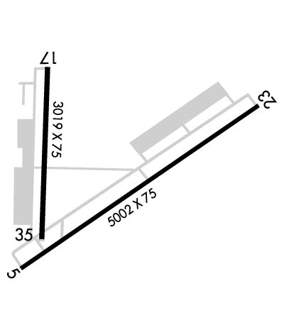
Runway Identifications
Runway Identification: 05/23Length: 5002 ft
Width: 75 ft
Surface: CONCRETE-GOOD CONDITION
Edge lights: Medium IntensityTreatment: NONE
| | Runway: 05 | | Runway: 23 |
| Mag heading: | 53° | Mag heading: | 233° |
| Rwy Slope: | -.46% Down | Rwy Slope: | .46% Up |
| Approach: | LOC/DME | Approach: | |
| Pattern: | Left Traffic | Pattern: | Right Traffic |
| Markings: | PRECISION INSTRUMENT | Markings: | NONPRECISION INSTRUMENT |
| Marking Condition: | GOOD | Marking Condition: | GOOD |
| Arresting Dev: | | Arresting Dev: | |
| Lat & Long: | N3449.7 W09215.5 | Lat. & Long.: | N3450.2 W09214.7 |
| Elev: | 541.2 ft. MSL | Elev: | 518.0 ft. MSL |
| TCH: | 49 ft. AGL | TCH: | 43 ft. AGL |
| Visual Glide Path: | 3.00 degrees | Visual Glide Path: | 3.00 degrees |
| Displaced Threshold: | No | Displaced Threshold: | No |
| Touchdown Zone: | YES | Touchdown Zone: | YES |
| Touchdown Elev.: | 541.3 feet | Touchdown Elev.: | 537.0 feet |
| Visual Glide Slope: | 2-Light PAPI on RIGHT side of Runway | Visual Glide Slope: | 2-Light PAPI on LEFT side of Runway |
| RVR Equipment: | | RVR Equipment: | |
| RVV Equipment: | NO | RVV Equipment: | NO |
| Approach Lights: | | Approach Lights: | |
| REIL: | YES | REIL: | YES |
| Centerline Lights: | NO | Centerline Lights: | NO |
| Touchdown lights: | NO | Touchdown lights: | NO |
| Runway Category: | Runway with a Non-precision Approach having visibility minimums greater than 3/4 mile | Runway Category: | Runway with a Visual Approach |
| Declared Distances: | | Declared Distances: | |
| Obstructions: | TREES | Obstructions: | |
| Marked: | NOT Marked/Lighted | Marked: | |
| Clearance slope: | 46:1 | Clearance slope: | 20:1 |
| Obstruction height: | 16 feet AGL | Obstruction height: | |
| Dist. from runway: | 950 feet | Dist. from runway: | |
| Centerline offset: | 100 right of centerline | Centerline offset: | |
| Comments: | | Comments: | |
Runway Identification: 17/35Length: 3019 ft
Width: 75 ft
Surface: ASPHALT-FAIR CONDITION
Edge lights: Medium IntensityTreatment: NONE
| | Runway: 17 | | Runway: 35 |
| Mag heading: | 178° | Mag heading: | 358° |
| Rwy Slope: | -.10% Down | Rwy Slope: | .10% Up |
| Approach: | | Approach: | |
| Pattern: | Right Traffic | Pattern: | Left Traffic; CALM WIND PREFERRED TKOF/LNDG TO THE NORTH WHEN POSSIBLE. |
| Markings: | NONPRECISION INSTRUMENT | Markings: | NONPRECISION INSTRUMENT |
| Marking Condition: | FAIR | Marking Condition: | FAIR |
| Arresting Dev: | | Arresting Dev: | |
| Lat & Long: | N3450.3 W09215.4 | Lat. & Long.: | N3449.8 W09215.4 |
| Elev: | 544.1 ft. MSL | Elev: | 541.1 ft. MSL |
| TCH: | 44 ft. AGL | TCH: | 44 ft. AGL |
| Visual Glide Path: | 3.00 degrees | Visual Glide Path: | 3.00 degrees |
| Displaced Threshold: | No | Displaced Threshold: | No |
| Touchdown Zone: | YES | Touchdown Zone: | YES |
| Touchdown Elev.: | 545.4 feet | Touchdown Elev.: | 545.4 feet |
| Visual Glide Slope: | 2-Light PAPI on LEFT side of Runway | Visual Glide Slope: | 2-Light PAPI on LEFT side of Runway |
| RVR Equipment: | | RVR Equipment: | |
| RVV Equipment: | NO | RVV Equipment: | NO |
| Approach Lights: | | Approach Lights: | |
| REIL: | YES | REIL: | NO |
| Centerline Lights: | NO | Centerline Lights: | NO |
| Touchdown lights: | NO | Touchdown lights: | NO |
| Runway Category: | Runway with a Visual Approach | Runway Category: | Runway with a Non-precision Approach |
| Declared Distances: | | Declared Distances: | |
| Obstructions: | GND | Obstructions: | TREES |
| Marked: | NOT Marked/Lighted | Marked: | NOT Marked/Lighted |
| Clearance slope: | | Clearance slope: | 34:1 |
| Obstruction height: | 12 feet AGL | Obstruction height: | 26 feet AGL |
| Dist. from runway: | 200 feet | Dist. from runway: | 1100 feet |
| Centerline offset: | 200 left of centerline | Centerline offset: | |
| Comments: | +12 FT BERM 100 FT FM RY END 200 FT L & R OF CNTRLN EXTENDED INTO PRIMARY SFC. | Comments: | |

