Click here for more info on on SMS!

KORF

NORFOLK INTL
NORFOLK
VA
Time Zone: Eastern
Lat: N 3653.7
Long: W 07612.1
Elev: 26
Var: +09
Longest Runway: 9001
Clr Del: 118.5
Dept. ATIS: 127.15
Arr. ATIS: 127.15
Ground: 121.9
Tower: 120.8

FBO & Flight Services info for KORF

FBOs: Update your Fuel Prices
Airliner support, crew cars, pilot's lounge & snooze room, on-site car rental, Internet and flight planning/weather room, parts, maintenance, avionics, power starts, corporate hangars/T-hangars, aircaft washing, conference room, 24/7.
Ph: 800-486-4041 Fax: 757-857-3409 Freq: 130.57WebsiteE-Mail
                                   
Service
Jet
100LL
SAF
MoGas
Fuel Avail: PRIST +$0.08/gal.
Full7.167.45    Last Update: 04/26/2024 10:15

Self        
Misc. Info: Address: 6101 BURTON STATION ROAD   NORFOLK, VA 23502

ATISPh: 757-464-1390
-
-
 
ASOSPh: 757-460-9348
-
-
 
If you are an FBO, call 1-203-262-1700 to update your info or email: FltPlan.Advertising@garmin.com
Advertise your FBO on FltPlan.com

Runway & Approach Info for KORF
Rwy
Length
Land Dist**
Approach*
  Rwy
Length
Land Dist**
Approach*
05
9001x150  8000'          
ILS/DME
 109.10 - 046°  
  
23
  9001x150  9001'          
ILS/DME
 109.10 - 226°  
14
4876x150  4301'          
 
  
32
  4876x150  4876'          
 
 * only ILS, LOC, LDA, and SDF approaches to a specific runway are shown
** For any Declared Landing Distance Available, please see A/FD or Approach plates
Runway Weight Capability (lbs.) Help
Runway IDSingle WheelDouble WheelDouble Tandem WheelDual Double Wheel
05/23150,000200,000350,000475,000
14/3275,000100,000N/AN/A
These numbers are Advisory and are not limits.   The Airport Manager should have more accurate Weight Limits
Approach Charts
Approaches    
Current Weather/Notams
Customs Information Send updates to Support@FltPlan.com
Phone 757-533-4200
Fax 757-858-6104

Comments 2 hrs advance notice required. Business hrs 0800-1700 Monday-Friday. *Call prior to 1500 on preceding weekday. *For weekend and holiday flights call prior to 1500 on the preceding weekday.
Database effective 05/16/2024
Airport Diagram of KORF
Airport Diagram might not be current.

Facility Name: NORFOLK INTL
City Name: NORFOLK
County: NORFOLK
State abbrev: VA
State Name: VIRGINIA
   
Ownership: PUBLICLY OWNED
Use: OPEN TO THE PUBLIC
Owner's Name: NORFOLK AIRPORT AUTH
Address: 2200 NORVIEW AVE
 NORFOLK, VA 23518-5807
Owner's Phone: 757-857-3351
  
Manager's Name: MARK PERRYMAN, PRESIDENT & CEO
Address: 2200 NORVIEW AVE
 NORFOLK, VA 23518-5807
Phone: 757-857-3344; POLICE DISPATCH.
   
FAA Region: EASTERN
FAA Field Office: DCA
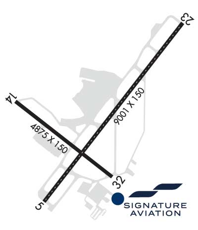

Sunrise / Sunset times for NORFOLK INTL

DateSunriseSunset
04/25/24 Thursday6:1719:49
04/26/24 Friday6:1619:50
04/27/24 Saturday6:1419:51
04/28/24 Sunday6:1319:52
04/29/24 Monday6:1219:53
04/30/24 Tuesday6:1119:53
05/01/24 Wednesday6:1019:54
05/02/24 Thursday6:0919:55
05/03/24 Friday6:0819:56
05/04/24 Saturday6:0719:57
05/05/24 Sunday6:0619:58
05/06/24 Monday6:0519:59
05/07/24 Tuesday6:0420:00
05/08/24 Wednesday6:0320:00

Airport Facilities

Airport Attendance ScheduleCONTINUOUS
Airport Status OPERATIONAL (This Status can change at any time - please check NOTAMS)
Airport Lighting ScheduleSS-SR
Airport Storage AvailableTie Downs, Hanger
Extra Services AvailableAvionics, Cargo Handling, Charter, Flight Instruction
Wind IndicatorYES - (lighted)
Control TowerYES
CTAF Frequency
Unicom Frequency
Rotating Beacon ColorWG
Segmented CircleNO
Landing FeeYES

Airport Inspection Data

Airport InspectedFEDERAL - performed by FAA AIRPORTS FIELD PERSONNEL
Inspection Date04/27/2023

Airport Services

Type of Fuel AvailableGrade 100LL, JET A (freeze point -40C)
Airframe Repair ServiceMINOR
Power Plant Repair ServiceMINOR

Geographic Data

LatitudeN3653.7
LongitudeW07612.1 (ESTIMATED)
Arpt Elevation26ft (SURVEYED)
Magnetic Variation09W
3 miles NEof NORFOLK
Traffic Pattern Altitude
Sectional ChartWASHINGTON

Aircraft Data

Operations (Reported)YearlyAvg. Daily
General Aviation Transient 1536342
General Aviation Local 1550
Air Taxi 756721
Commerical 38498105
Commuter 00
Military 5431
Aircraft based on Field
General Aviation Singles 52
General Aviation Multi 31
Jet Aircraft 23
General Aviation Helicopters 2
Military Aircraft 0
Gliders 0
Ultralights 0

FAA Services

FSS on field NO
FSS tie-in LEESBURG
FSS Phone 1-800-WX-BRIEF
Who issues Notams ORF
Notam D service at airport YES
ARTCC Name WASHINGTON

Federal Status

Airport CertificationAIRPORT RECEIVING SCHEDULED AIR CARRIER SERVICE FROM CARRIERS CERTIFICATED BY THE CIVIL AERONAUTICS BOARD
Aircraft Rescue & Firefighting IndexAIRPORT HAS A CERTIFICATE UNDER CFR PART 139
Airport of EntryNo
Custom Landing RightsYES
Joint Civil/MilitaryNo
Military Landing rightsYES

Federal Agreements

NATIONAL PLAN OF INTEGRATED AIRPORT SYSTEMS (NPIAS)
GRANT AGREEMENTS UNDER FAAP/ADAP/AIP
COMPLIANCE WITH ACCESSIBILITY TO THE HANDICAPPED
SURPLUS PROPERTY AGREEMENT UNDER REGULATION 16-WAA
ASSURANCES PURSUANT TO TITLE VI, CIVIL RIGHTS ACT OF 1964
AGREEMENT UNDER DLAND OR DCLA HAS EXPIRED.

Remarks

NOISE ABATEMENT PROCEDURES IN EFFECT.
FLOCKS OF BIRDS ON & INVOF ARPT.
INTMT AIRFIELD MOWING OPS MAR - NOV.
RWY 05/2 3 CONC PTNS: LONGL CRACKS & SPALLING.
Airport Communications & Frequencies:
ATIS Frequencies:   Hours(local) of Operation: CONTINUOUS
127.15
NORFOLK Tower Frequencies:   Hours(local) of operation: CONTINUOUS   
120.8
257.8
NORFOLK Ground Frequencies:
121.9
Clearance Delivery Frequencies:
118.5
Pre-Taxi Clearance Frequencies:
118.5
Emergency Frequencies:
121.5
243.0
NORFOLK Primary Approach Frequencies:   Hours(local) of operation: CONTINUOUS   
118.9 ;010-080, 180-310
335.625
353.7 ;010-080, 180-310
NORFOLK Primary Departure Frequencies:   Hours(local) of operation: CONTINUOUS   
125.2
363.125
379.1
Class C Frequencies:
118.9 ;010-080, 180-310
125.7 ;311-009
353.7 ;010-080, 180-310
379.1 ;311-009
Runway Identifications
Runway Identification: 05/23
Length: 9001 ft
Width: 150 ft
Surface: CONCRETE ASPHALT-FAIR CONDITION
Edge lights: High Intensity

Treatment: GROOVED
Weight: PCN 53 /R/C/W/T

 Runway: 05   Runway: 23
Mag heading: 47°Mag heading: 227°
Rwy Slope: -.03% DownRwy Slope: .03% Up
Approach: ILS/DMEApproach: ILS/DME
Pattern: Right TrafficPattern: Left Traffic
Markings: PRECISION INSTRUMENTMarkings: PRECISION INSTRUMENT
Marking Condition: GOODMarking Condition: GOOD
Arresting Dev: Arresting Dev:
Lat & Long: N3653.2  W07612.5Lat. & Long.: N3654.3  W07611.4
Elev: 17.7 ft. MSLElev: 15.0 ft. MSL
TCH: 71 ft. AGLTCH: 55 ft. AGL
Visual Glide Path: 3.00 degreesVisual Glide Path: 3.00 degrees
Displaced Threshold: 1001 feetDisplaced Threshold: No
Touchdown Zone: YESTouchdown Zone: YES
Touchdown Elev.: 26.1 feetTouchdown Elev.: 25.8 feet
Visual Glide Slope: 4-Light PAPI on LEFT side of RunwayVisual Glide Slope: 4-Light PAPI on LEFT side of Runway
RVR Equipment: TOUCHDOWNRVR Equipment: ROLLOUT
RVV Equipment: YESRVV Equipment: NO
Approach Lights: MALSR - 1,400 foot medium intensity approach lighting system with runway alignment indicator lightsApproach Lights: MALSR - 1,400 foot medium intensity approach lighting system with runway alignment indicator lights
REIL: NOREIL: NO
Centerline Lights: YESCenterline Lights: YES
Touchdown lights: NOTouchdown lights: NO
Runway Category: Precision Instrument RunwayRunway Category: Precision Instrument Runway
Declared Distances: TORA:9001' TODA:9001' ASDA:8809' LDA:7809'Declared Distances: TORA:9001' TODA:9001' ASDA:8995' LDA:8995'
Obstructions: TREESObstructions: POLE
Marked: NOT Marked/LightedMarked: LIGHTED
Clearance slope: 46:1; APCH RATIO 50:1 TO DSPLCD THR.Clearance slope: 26:1
Obstruction height: 41 feet AGLObstruction height: 49 feet AGL
Dist. from runway: 2100 feetDist. from runway: 1500 feet
Centerline offset: 380 left of centerlineCenterline offset: 150 feet right of centerline
Comments: Comments: RWY 23 +1' FNC 80' FM RY END 400' R 10' FCN 0-200 270' L
Runway Identification: 14/32
Length: 4876 ft
Width: 150 ft
Surface: ASPHALT-GOOD CONDITION
Edge lights: Medium Intensity

Treatment: GROOVED
Weight: PCN 27 /F/A/W/T

 Runway: 14   Runway: 32
Mag heading: 137°Mag heading: 317°
Rwy Slope: .08% UpRwy Slope: -.08% Down
Approach: Approach:
Pattern: Right TrafficPattern: Left Traffic
Markings: NONPRECISION INSTRUMENTMarkings: NONPRECISION INSTRUMENT
Marking Condition: GOODMarking Condition: GOOD
Arresting Dev: Arresting Dev:
Lat & Long: N3653.8  W07612.7Lat. & Long.: N3653.3  W07611.9
Elev: 17.7 ft. MSLElev: 21.7 ft. MSL
TCH: 36 ft. AGLTCH: 34 ft. AGL
Visual Glide Path: 3.00 degreesVisual Glide Path: 3.00 degrees
Displaced Threshold: 575 feetDisplaced Threshold: No
Touchdown Zone: YESTouchdown Zone: YES
Touchdown Elev.: 24.3 feetTouchdown Elev.: 24.3 feet
Visual Glide Slope: 2-Light PAPI on LEFT side of RunwayVisual Glide Slope: 2-Light PAPI on LEFT side of Runway
RVR Equipment: RVR Equipment:
RVV Equipment: NORVV Equipment: NO
Approach Lights: Approach Lights:
REIL: YESREIL: YES
Centerline Lights: NOCenterline Lights: NO
Touchdown lights: NOTouchdown lights: NO
Runway Category: Runway with a Non-precision Approach having visibility minimums greater than 3/4 mileRunway Category: Runway with a Non-precision Approach having visibility minimums greater than 3/4 mile
Declared Distances: TORA:4876' TODA:4876' ASDA:4876' LDA:4301'Declared Distances: TORA:4876' TODA:4876' ASDA:3901' LDA:3901'
Obstructions: TREEObstructions: TREE
Marked: NOT Marked/LightedMarked: NOT Marked/Lighted
Clearance slope: 16:1; APCH RATIO 26:1 TO DSPLCD THR.Clearance slope: 23:1
Obstruction height: 61 feet AGLObstruction height: 103 feet AGL
Dist. from runway: 1226 feetDist. from runway: 2590 feet
Centerline offset: 74BCenterline offset: 430 feet left of centerline
Comments: Comments:
C:142/P: