Current Weather/Notams (Metars, TAFs, Notams, NWS Forecast, PIREPS, and nearby weather)
Customs Information Send updates to Support@FltPlan.com
Customs Not Available
Database effective 05/16/2024
Airport Diagram might not be current.
|
| Facility Name: | BRANDYWINE RGNL |
| City Name: | WEST CHESTER |
| County: | CHESTER |
| State abbrev: | PA |
| State Name: | PENNSYLVANIA |
| | |
| Ownership: | PRIVATELY OWNED |
| Use: | OPEN TO THE PUBLIC |
| Owner's Name: | BRANDYWINE REGIONAL AIRPORT, INC |
| Address: | 1205 WARD AVE |
| | WEST CHESTER, PA 19380 |
| Owner's Phone: | 610-692-6100 |
| | |
| Manager's Name: | JOHN KASSAB |
| Address: | 1205 WARD AVE |
| | WEST CHESTER, PA 19380 |
| Phone: | 610-692-6100 |
| | |
| FAA Region: | EASTERN |
| FAA Field Office: | HAR |
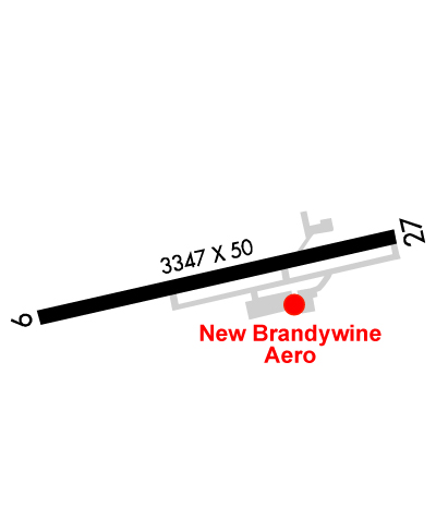
Runway Identifications
Runway Identification: 09/27Length: 3347 ft
Width: 50 ft
Surface: ASPHALT-GOOD CONDITION
Edge lights: Low IntensityTreatment: NONE
| | Runway: 09 | | Runway: 27 |
| Mag heading: | 89° | Mag heading: | 269° |
| Rwy Slope: | .22% Up | Rwy Slope: | -.22% Down |
| Approach: | | Approach: | |
| Pattern: | Right Traffic | Pattern: | Left Traffic |
| Markings: | NONPRECISION INSTRUMENT | Markings: | NONPRECISION INSTRUMENT |
| Marking Condition: | GOOD | Marking Condition: | GOOD |
| Arresting Dev: | | Arresting Dev: | |
| Lat & Long: | N3959.3 W07535.3 | Lat. & Long.: | N3959.5 W07534.6 |
| Elev: | 453.3 ft. MSL | Elev: | 460.6 ft. MSL |
| TCH: | 23 ft. AGL | TCH: | 20 ft. AGL |
| Visual Glide Path: | 4.20 degrees | Visual Glide Path: | 3.00 degrees |
| Displaced Threshold: | 125 feet | Displaced Threshold: | 249 feet |
| Touchdown Zone: | YES | Touchdown Zone: | YES |
| Touchdown Elev.: | 464.6 feet | Touchdown Elev.: | 464.6 feet |
| Visual Glide Slope: | 2-Light PAPI on LEFT side of Runway; PAPI OPS CONS. | Visual Glide Slope: | 2-Light PAPI on LEFT side of Runway; PAPI OPS CONS. |
| RVR Equipment: | | RVR Equipment: | |
| RVV Equipment: | NO | RVV Equipment: | NO |
| Approach Lights: | | Approach Lights: | |
| REIL: | NO | REIL: | NO |
| Centerline Lights: | NO | Centerline Lights: | NO |
| Touchdown lights: | NO | Touchdown lights: | NO |
| Runway Category: | Runway with a Non-precision Approach | Runway Category: | Runway with a Non-precision Approach |
| Declared Distances: | | Declared Distances: | |
| Obstructions: | TREES | Obstructions: | |
| Marked: | NOT Marked/Lighted | Marked: | |
| Clearance slope: | 16:1; APCH RATIO 20:1 TO DTHR. | Clearance slope: | 20:1 |
| Obstruction height: | 92 feet AGL | Obstruction height: | |
| Dist. from runway: | 1687 feet | Dist. from runway: | |
| Centerline offset: | 389 right of centerline | Centerline offset: | |
| Comments: | | Comments: | ROAD TRAVERSING THE 200 FT PRIMARY SFC AREA BYD EOR; ROAD RISES TO +13 FT AT A POINT 14 FT FROM EOR 265 FT R. |