Current Weather/Notams (Metars, TAFs, Notams, NWS Forecast, PIREPS, and nearby weather)
Customs Information Send updates to Support@FltPlan.com
Customs Not Available
Database effective 04/18/2024
Airport Diagram might not be current.
|
| Facility Name: | THOMASTON-UPSON COUNTY |
| City Name: | THOMASTON |
| County: | UPSON |
| State abbrev: | GA |
| State Name: | GEORGIA |
| | |
| Ownership: | PUBLICLY OWNED |
| Use: | OPEN TO THE PUBLIC |
| Owner's Name: | THOMASTON UPSON CO. ARPT AUTH |
| Address: | 2347 DERAY RD |
| | THOMASTON, GA 30286 |
| Owner's Phone: | 706-647-4500 |
| | |
| Manager's Name: | MITCH ELLERBEE |
| Address: | 2347 DEL RAY ROAD |
| | THOMASTON, GA 30286 |
| Phone: | 706-647-4500 |
| | |
| FAA Region: | SOUTHERN |
| FAA Field Office: | ATL |
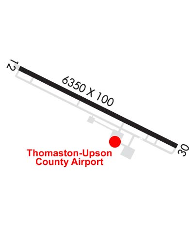
Runway Identifications
Runway Identification: 12/30Length: 6350 ft
Width: 100 ft
Surface: ASPHALT-GOOD CONDITION
Edge lights: Medium IntensityTreatment: NONE
| | Runway: 12 | | Runway: 30 |
| Mag heading: | 121° | Mag heading: | 301° |
| Rwy Slope: | .17% Up | Rwy Slope: | -.17% Down |
| Approach: | | Approach: | ILS/DME |
| Pattern: | Left Traffic | Pattern: | Left Traffic |
| Markings: | PRECISION INSTRUMENT | Markings: | PRECISION INSTRUMENT |
| Marking Condition: | GOOD | Marking Condition: | GOOD |
| Arresting Dev: | | Arresting Dev: | |
| Lat & Long: | N3257.5 W08416.4 | Lat. & Long.: | N3257.1 W08415.3 |
| Elev: | 786.8 ft. MSL | Elev: | 797.5 ft. MSL |
| TCH: | 32 ft. AGL | TCH: | 27 ft. AGL |
| Visual Glide Path: | 3.50 degrees | Visual Glide Path: | 3.00 degrees |
| Displaced Threshold: | 648 feet | Displaced Threshold: | 699 feet |
| Touchdown Zone: | YES | Touchdown Zone: | YES |
| Touchdown Elev.: | 790.7 feet | Touchdown Elev.: | 795.8 feet |
| Visual Glide Slope: | 2-Light PAPI on LEFT side of Runway | Visual Glide Slope: | 2-Light PAPI on LEFT side of Runway |
| RVR Equipment: | | RVR Equipment: | |
| RVV Equipment: | NO | RVV Equipment: | NO |
| Approach Lights: | | Approach Lights: | MALSR - 1,400 foot medium intensity approach lighting system with runway alignment indicator lights |
| REIL: | NO | REIL: | NO |
| Centerline Lights: | NO | Centerline Lights: | NO |
| Touchdown lights: | NO | Touchdown lights: | NO |
| Runway Category: | Runway with a Non-precision Approach having visibility minimums greater than 3/4 mile | Runway Category: | Precision Instrument Runway |
| Declared Distances: | TORA:6350' TODA:6350' ASDA:6173' LDA:5525' | Declared Distances: | TORA:6350' TODA:6350' ASDA:5662' LDA:4962' |
| Obstructions: | ROAD | Obstructions: | RR |
| Marked: | NOT Marked/Lighted | Marked: | NOT Marked/Lighted |
| Clearance slope: | 34:1 APCH TO DSPLCD THLD. | Clearance slope: | 10:1; 50:1 APCH TO DSPLCD THLD. |
| Obstruction height: | 15 feet AGL | Obstruction height: | 16 feet AGL |
| Dist. from runway: | 201 feet | Dist. from runway: | 360 feet |
| Centerline offset: | 250 left of centerline | Centerline offset: | |
| Comments: | 6 FT FENCE AND ROAD 198 FT LEFT 200 FT FROM RY END. | Comments: | |