Current Weather/Notams (Metars, TAFs, Notams, NWS Forecast, PIREPS, and nearby weather)
Customs Information Send updates to Support@FltPlan.com
Customs Not Available
Database effective 04/18/2024
Airport Diagram might not be current.
|
| Facility Name: | ST LANDRY PARISH |
| City Name: | OPELOUSAS |
| County: | ST LANDRY |
| State abbrev: | LA |
| State Name: | LOUISIANA |
| | |
| Ownership: | PUBLICLY OWNED |
| Use: | OPEN TO THE PUBLIC |
| Owner's Name: | ST. LANDRY PARISH GOVERNMENT |
| Address: | ST. LANDRY PARISH, P. O. DRAWER 1550 |
| | OPELOUSAS, LA 70571 |
| Owner's Phone: | 337-948-3688 |
| | |
| Manager's Name: | LLOYD ARDOIN |
| Address: | 299 HANGAR RD. |
| | OPELOUSAS, LA 70570 |
| Phone: | 337-407-1551; AFTER HRS EMERG CELL 337-351-0025. |
| | |
| FAA Region: | SOUTHWEST |
| FAA Field Office: | LNM |
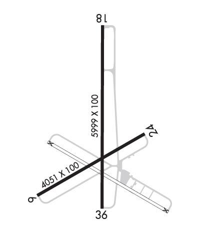
Runway Identifications
Runway Identification: 06/24Length: 4051 ft
Width: 100 ft
Surface: CONCRETE-FAIR CONDITION
Edge lights: Treatment: NONE
| | Runway: 06 | | Runway: 24 |
| Mag heading: | 59° | Mag heading: | 239° |
| Rwy Slope: | .12% Up | Rwy Slope: | -.12% Down |
| Approach: | | Approach: | |
| Pattern: | Left Traffic | Pattern: | Right Traffic |
| Markings: | BASIC | Markings: | BASIC |
| Marking Condition: | POOR; RWY MARKINGS ARE FADED. | Marking Condition: | POOR; RWY MARKINGS ARE FADED. |
| Arresting Dev: | | Arresting Dev: | |
| Lat & Long: | N3033.2 W09206.3 | Lat. & Long.: | N3033.5 W09205.7 |
| Elev: | 69.1 ft. MSL | Elev: | 73.9 ft. MSL |
| TCH: | | TCH: | |
| Visual Glide Path: | | Visual Glide Path: | |
| Displaced Threshold: | 165 feet | Displaced Threshold: | 169 feet |
| Touchdown Zone: | YES | Touchdown Zone: | YES |
| Touchdown Elev.: | 73.8 feet | Touchdown Elev.: | 74.2 feet |
| Visual Glide Slope: | | Visual Glide Slope: | |
| RVR Equipment: | | RVR Equipment: | |
| RVV Equipment: | NO | RVV Equipment: | NO |
| Approach Lights: | | Approach Lights: | |
| REIL: | NO | REIL: | NO |
| Centerline Lights: | NO | Centerline Lights: | NO |
| Touchdown lights: | NO | Touchdown lights: | NO |
| Runway Category: | Runway with a Visual Approach | Runway Category: | Runway with a Visual Approach |
| Declared Distances: | | Declared Distances: | |
| Obstructions: | TREES | Obstructions: | TREES |
| Marked: | NOT Marked/Lighted | Marked: | NOT Marked/Lighted |
| Clearance slope: | 6:1; APCH RATIO 10:1 FM DSPLCD THLD. | Clearance slope: | 13:1; APCH RATIO 16:1 FM DSPLCD THLD. |
| Obstruction height: | 46 feet AGL | Obstruction height: | 56 feet AGL |
| Dist. from runway: | 520 feet | Dist. from runway: | 941 feet |
| Centerline offset: | 110 left of centerline | Centerline offset: | 16 feet left of centerline |
| Comments: | | Comments: | |
Runway Identification: 18/36Length: 5999 ft
Width: 100 ft
Surface: CONCRETE-GOOD CONDITION
Edge lights: Medium IntensityTreatment: NONE
| | Runway: 18 | | Runway: 36 |
| Mag heading: | 179° | Mag heading: | 359° |
| Rwy Slope: | .00% Up | Rwy Slope: | .00% Down |
| Approach: | | Approach: | |
| Pattern: | Right Traffic | Pattern: | Left Traffic |
| Markings: | NONPRECISION INSTRUMENT | Markings: | NONPRECISION INSTRUMENT |
| Marking Condition: | GOOD | Marking Condition: | GOOD |
| Arresting Dev: | | Arresting Dev: | |
| Lat & Long: | N3034.1 W09205.9 | Lat. & Long.: | N3033.1 W09205.9 |
| Elev: | 70.5 ft. MSL | Elev: | 70.6 ft. MSL |
| TCH: | 58 ft. AGL | TCH: | 59 ft. AGL |
| Visual Glide Path: | 3.50 degrees | Visual Glide Path: | 3.50 degrees |
| Displaced Threshold: | 150 feet | Displaced Threshold: | 789 feet |
| Touchdown Zone: | YES | Touchdown Zone: | YES |
| Touchdown Elev.: | 71.0 feet | Touchdown Elev.: | 73.2 feet |
| Visual Glide Slope: | 2-Light PAPI on LEFT side of Runway | Visual Glide Slope: | 2-Light PAPI on LEFT side of Runway |
| RVR Equipment: | | RVR Equipment: | |
| RVV Equipment: | NO | RVV Equipment: | NO |
| Approach Lights: | | Approach Lights: | |
| REIL: | YES | REIL: | YES |
| Centerline Lights: | NO | Centerline Lights: | NO |
| Touchdown lights: | NO | Touchdown lights: | NO |
| Runway Category: | Runway with a Non-precision Approach having visibility minimums greater than 3/4 mile | Runway Category: | Runway with a Non-precision Approach having visibility minimums greater than 3/4 mile |
| Declared Distances: | | Declared Distances: | |
| Obstructions: | TREE | Obstructions: | ROAD |
| Marked: | NOT Marked/Lighted | Marked: | NOT Marked/Lighted |
| Clearance slope: | 15:1; APCH SLOPE 16:1 TO DSPLCD THLD. | Clearance slope: | 5:1; APCH SLOPE 30:1 TO DSPLCD THLD. |
| Obstruction height: | 48 feet AGL | Obstruction height: | 19 feet AGL |
| Dist. from runway: | 943 feet | Dist. from runway: | 307 feet |
| Centerline offset: | 114 left of centerline | Centerline offset: | |
| Comments: | | Comments: | |

