Current Weather/Notams (Metars, TAFs, Notams, NWS Forecast, PIREPS, and nearby weather)
Customs Information Send updates to Support@FltPlan.com
Customs Not Available
Database effective 05/16/2024
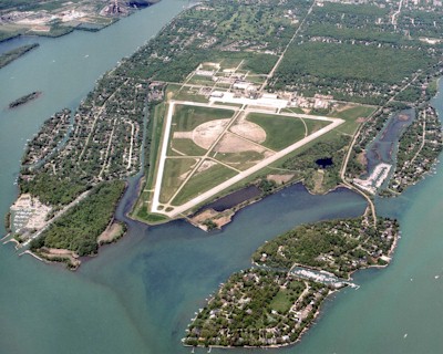
Airport Diagram might not be current. Facility Name: GROSSE ILE MUNI City Name: DETROIT/GROSSE ILE County: WAYNE State abbrev: MI State Name: MICHIGAN Ownership: PUBLICLY OWNED Use: OPEN TO THE PUBLIC Owner's Name: TOWNSHIP OF GROSSE ILE Address: 9601 GROH RD, PO BOX 129 GROSSE ILE, MI 48138 Owner's Phone: 734-675-0155 Manager's Name: JANEL MACNEE Address: 9601 GROH RD, PO BOX 129 GROSSE ILE, MI 48138 Phone: 734-675-0155 FAA Region: GREAT LAKES FAA Field Office: DET
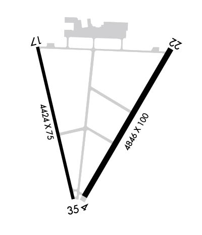
Runway Identifications Help
Runway Identification: 04/22 Length: 4846 ftWidth: 100 ftSurface: ASPHALT-GOOD CONDITIONEdge lights: Medium Intensity Treatment: NONE Runway: 04 Runway: 22 Mag heading: 37° Mag heading: 217° Rwy Slope: .26% Up Rwy Slope: -.26% Down Approach: Approach: Pattern: Right Traffic Pattern: Left Traffic Markings: NONPRECISION INSTRUMENT Markings: NONPRECISION INSTRUMENT Marking Condition: GOOD Marking Condition: GOOD Arresting Dev: Arresting Dev: Lat & Long: N4205.6 W08309.7 Lat. & Long.: N4206.3 W08309.2 Elev: 576.8 ft. MSL Elev: 589.3 ft. MSL TCH: 40 ft. AGL TCH: 40 ft. AGL Visual Glide Path: 3.04 degrees Visual Glide Path: 3.04 degrees Displaced Threshold: No Displaced Threshold: 428 feet Touchdown Zone: YES Touchdown Zone: YES Touchdown Elev.: 587.9 feet Touchdown Elev.: 590.5 feet Visual Glide Slope: 4-Light PAPI on LEFT side of Runway Visual Glide Slope: 4-Light PAPI on LEFT side of Runway RVR Equipment: RVR Equipment: RVV Equipment: NO RVV Equipment: NO Approach Lights: Approach Lights: REIL: YES REIL: YES Centerline Lights: NO Centerline Lights: NO Touchdown lights: NO Touchdown lights: NO Runway Category: Runway with a Non-precision Approach having visibility minimums greater than 3/4 mile Runway Category: Runway with a Non-precision Approach having visibility minimums greater than 3/4 mile Declared Distances: Declared Distances: Obstructions: TREE Obstructions: TREES Marked: NOT Marked/Lighted Marked: NOT Marked/Lighted Clearance slope: 17:1 Clearance slope: 13:1; APCH RATIO 25:1 TO DTHR. Obstruction height: 34 feet AGL Obstruction height: 75 feet AGL Dist. from runway: 795 feet Dist. from runway: 1190 feet Centerline offset: 308 left of centerline Centerline offset: 382 feet left of centerline Comments: Comments:
Runway Identification: 17/35 Length: 4424 ftWidth: 75 ftSurface: CONCRETE-POOR CONDITIONEdge lights: Medium Intensity Treatment: NONE Runway: 17 Runway: 35 Mag heading: 174° Mag heading: 354° Rwy Slope: -.07% Down Rwy Slope: .07% Up Approach: Approach: Pattern: Left Traffic Pattern: Right Traffic Markings: BASIC Markings: BASIC Marking Condition: FAIR Marking Condition: FAIR Arresting Dev: Arresting Dev: Lat & Long: N4206.3 W08310.0 Lat. & Long.: N4205.6 W08309.8 Elev: 581.3 ft. MSL Elev: 578.3 ft. MSL TCH: 26 ft. AGL TCH: 20 ft. AGL Visual Glide Path: 3.00 degrees Visual Glide Path: 3.00 degrees Displaced Threshold: 672 feet Displaced Threshold: No Touchdown Zone: YES Touchdown Zone: YES Touchdown Elev.: 580.3 feet Touchdown Elev.: 579.7 feet Visual Glide Slope: 4-Light PAPI on LEFT side of Runway Visual Glide Slope: 4-Light PAPI on LEFT side of Runway RVR Equipment: RVR Equipment: RVV Equipment: NO RVV Equipment: NO Approach Lights: Approach Lights: REIL: NO REIL: NO Centerline Lights: NO Centerline Lights: NO Touchdown lights: NO Touchdown lights: NO Runway Category: Runway with a Visual Approach Runway Category: Runway with a Visual Approach Declared Distances: Declared Distances: Obstructions: TREES Obstructions: Marked: NOT Marked/Lighted Marked: Clearance slope: 12:1; APCH RATIO 22:1 TO DTHR. Clearance slope: 20:1 Obstruction height: 80 feet AGL Obstruction height: Dist. from runway: 1180 feet Dist. from runway: Centerline offset: 40 right of centerline Centerline offset: Comments: Comments: