Current Weather/Notams (Metars, TAFs, Notams, NWS Forecast, PIREPS, and nearby weather)
Customs Information Send updates to Support@FltPlan.com
Customs Not Available
Database effective 04/18/2024
Airport Diagram might not be current.
|
| Facility Name: | OLNEY MUNI |
| City Name: | OLNEY |
| County: | YOUNG |
| State abbrev: | TX |
| State Name: | TEXAS |
| | |
| Ownership: | PUBLICLY OWNED |
| Use: | OPEN TO THE PUBLIC |
| Owner's Name: | CITY OF OLNEY |
| Address: | 201 EAST MAIN |
| | OLNEY, TX 76374 |
| Owner's Phone: | 940-564-2102 |
| | |
| Manager's Name: | JIM HIRSCH |
| Address: | PO BOX 485, 1524 LELAND SNOW WAY |
| | OLNEY, TX 76374 |
| Phone: | 940-564-5616; 940-250-9121 AMGR CELL. |
| | |
| FAA Region: | SOUTHWEST |
| FAA Field Office: | TEX |
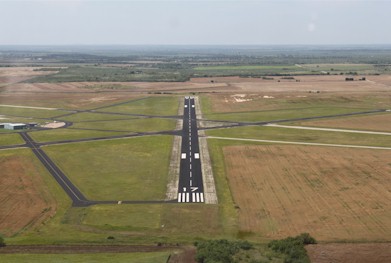
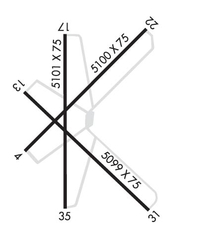
Runway Identifications
Runway Identification: 04/22Length: 5100 ft
Width: 75 ft
Surface: ASPHALT-GOOD CONDITION
Edge lights: Treatment: RUBBERIZED FRICTION SEAL COAT
| | Runway: 04 | | Runway: 22 |
| Mag heading: | 40° | Mag heading: | 220° |
| Rwy Slope: | .10% Up | Rwy Slope: | -.10% Down |
| Approach: | | Approach: | |
| Pattern: | Left Traffic | Pattern: | Left Traffic |
| Markings: | BASIC | Markings: | BASIC |
| Marking Condition: | FAIR | Marking Condition: | FAIR |
| Arresting Dev: | | Arresting Dev: | |
| Lat & Long: | N3320.9 W09849.5 | Lat. & Long.: | N3321.5 W09848.8 |
| Elev: | 1264.4 ft. MSL | Elev: | 1269.3 ft. MSL |
| TCH: | | TCH: | |
| Visual Glide Path: | | Visual Glide Path: | |
| Displaced Threshold: | No | Displaced Threshold: | No |
| Touchdown Zone: | YES | Touchdown Zone: | YES |
| Touchdown Elev.: | 1267.5 feet | Touchdown Elev.: | 1269.4 feet |
| Visual Glide Slope: | | Visual Glide Slope: | |
| RVR Equipment: | | RVR Equipment: | |
| RVV Equipment: | NO | RVV Equipment: | NO |
| Approach Lights: | | Approach Lights: | |
| REIL: | NO | REIL: | NO |
| Centerline Lights: | NO | Centerline Lights: | NO |
| Touchdown lights: | NO | Touchdown lights: | NO |
| Runway Category: | Runway with a Visual Approach | Runway Category: | Runway with a Visual Approach |
| Declared Distances: | | Declared Distances: | |
| Obstructions: | TREES | Obstructions: | PLINE |
| Marked: | NOT Marked/Lighted | Marked: | NOT Marked/Lighted |
| Clearance slope: | 34:1 | Clearance slope: | 38:1 |
| Obstruction height: | 16 feet AGL | Obstruction height: | 50 feet AGL |
| Dist. from runway: | 746 feet | Dist. from runway: | 2125 feet |
| Centerline offset: | 250 left of centerline | Centerline offset: | |
| Comments: | | Comments: | |
Runway Identification: 13/31Length: 5099 ft
Width: 75 ft
Surface: ASPHALT
Edge lights: Treatment: NONE
| | Runway: 13 | | Runway: 31 |
| Mag heading: | 130° | Mag heading: | 310° |
| Rwy Slope: | -.56% Down | Rwy Slope: | .56% Up |
| Approach: | | Approach: | |
| Pattern: | Left Traffic | Pattern: | Left Traffic |
| Markings: | NUMBERS ONLY | Markings: | NUMBERS ONLY |
| Marking Condition: | POOR | Marking Condition: | POOR |
| Arresting Dev: | | Arresting Dev: | |
| Lat & Long: | N3321.2 W09849.5 | Lat. & Long.: | N3320.6 W09848.8 |
| Elev: | 1271.1 ft. MSL | Elev: | 1242.5 ft. MSL |
| TCH: | | TCH: | |
| Visual Glide Path: | | Visual Glide Path: | |
| Displaced Threshold: | No | Displaced Threshold: | No |
| Touchdown Zone: | YES | Touchdown Zone: | YES |
| Touchdown Elev.: | 1271.2 feet | Touchdown Elev.: | 1263.3 feet |
| Visual Glide Slope: | | Visual Glide Slope: | |
| RVR Equipment: | | RVR Equipment: | |
| RVV Equipment: | NO | RVV Equipment: | NO |
| Approach Lights: | | Approach Lights: | |
| REIL: | NO | REIL: | NO |
| Centerline Lights: | NO | Centerline Lights: | NO |
| Touchdown lights: | NO | Touchdown lights: | NO |
| Runway Category: | Runway with a Visual Approach | Runway Category: | Runway with a Visual Approach |
| Declared Distances: | | Declared Distances: | |
| Obstructions: | ROAD | Obstructions: | ROAD |
| Marked: | NOT Marked/Lighted | Marked: | NOT Marked/Lighted |
| Clearance slope: | 33:1 | Clearance slope: | 14:1 |
| Obstruction height: | 15 feet AGL | Obstruction height: | 15 feet AGL |
| Dist. from runway: | 700 feet | Dist. from runway: | 410 feet |
| Centerline offset: | 175 right of centerline | Centerline offset: | 250 feet left of centerline |
| Comments: | | Comments: | |
Runway Identification: 17/35Length: 5101 ft
Width: 75 ft
Surface: ASPHALT-FAIR CONDITION
Edge lights: Medium IntensityTreatment: RUBBERIZED FRICTION SEAL COAT
| | Runway: 17 | | Runway: 35 |
| Mag heading: | 175° | Mag heading: | 355° |
| Rwy Slope: | -.28% Down | Rwy Slope: | .28% Up |
| Approach: | | Approach: | |
| Pattern: | Left Traffic | Pattern: | Left Traffic |
| Markings: | NONPRECISION INSTRUMENT | Markings: | NONPRECISION INSTRUMENT |
| Marking Condition: | FAIR | Marking Condition: | FAIR |
| Arresting Dev: | | Arresting Dev: | |
| Lat & Long: | N3321.5 W09849.2 | Lat. & Long.: | N3320.6 W09849.2 |
| Elev: | 1275.3 ft. MSL | Elev: | 1260.8 ft. MSL |
| TCH: | 29 ft. AGL | TCH: | 37 ft. AGL |
| Visual Glide Path: | 3.00 degrees | Visual Glide Path: | 3.00 degrees |
| Displaced Threshold: | No | Displaced Threshold: | No |
| Touchdown Zone: | YES | Touchdown Zone: | YES |
| Touchdown Elev.: | 1275.4 feet | Touchdown Elev.: | 1267.2 feet |
| Visual Glide Slope: | 2-Box VASI on LEFT side of Runway | Visual Glide Slope: | 2-Box VASI on RIGHT side of Runway |
| RVR Equipment: | | RVR Equipment: | |
| RVV Equipment: | NO | RVV Equipment: | NO |
| Approach Lights: | | Approach Lights: | |
| REIL: | NO | REIL: | NO |
| Centerline Lights: | NO | Centerline Lights: | NO |
| Touchdown lights: | NO | Touchdown lights: | NO |
| Runway Category: | Runway with a Non-precision Approach having visibility minimums greater than 3/4 mile | Runway Category: | Runway with a Non-precision Approach having visibility minimums greater than 3/4 mile |
| Declared Distances: | | Declared Distances: | |
| Obstructions: | TREES | Obstructions: | ROAD |
| Marked: | NOT Marked/Lighted | Marked: | NOT Marked/Lighted |
| Clearance slope: | 17:1 | Clearance slope: | 25:1 |
| Obstruction height: | 22 feet AGL | Obstruction height: | 15 feet AGL |
| Dist. from runway: | 574 feet | Dist. from runway: | 575 feet |
| Centerline offset: | 19 right of centerline | Centerline offset: | |
| Comments: | | Comments: | |