Click here for more info on on SMS!

KONX

CURRITUCK COUNTY RGNL
CURRITUCK
NC
Time Zone: Eastern
Lat: N 3624.0
Long: W 07600.9
Elev: 18
Var: +10
Longest Runway: 5502
AWOS: 119.77
CTAF: 122.9

FBO & Flight Services info for KONX

FBOs: Update your Fuel Prices

CURRITUCK AIRPORTPh: 252-453-8032 Fax: N/A Freq: 122.9
Service
Jet
100LL
SAF
MoGas
Fuel Avail: JetA Truck service 0800-1600 7 days a week; After Hours service available (252)-232-6101
Full5.10      Last Update: 04/09/2024 10:13
PRICES GUARANTEED by FBO.
Self5.105.00    
AWOSPh: 252-453-8939
-
Freq: 119.77  
If you are an FBO, call 1-203-262-1700 to update your info or email: FltPlan.Advertising@garmin.com
Advertise your FBO on FltPlan.com

Runway & Approach Info for KONX
Rwy
Length
Land Dist**
Approach*
  Rwy
Length
Land Dist**
Approach*
05
5502x150  5502'          
 
  
23
  5502x150  5502'          
 
 * only ILS, LOC, LDA, and SDF approaches to a specific runway are shown
** For any Declared Landing Distance Available, please see A/FD or Approach plates
Runway Weight Capability (lbs.) Help
Runway IDSingle WheelDouble WheelDouble Tandem WheelDual Double Wheel
05/2335,00047,500N/AN/A
These numbers are Advisory and are not limits.   The Airport Manager should have more accurate Weight Limits
Approach Charts
Approaches    
Current Weather/Notams
Customs Information Send updates to Support@FltPlan.com
Customs Not Available
Database effective 04/18/2024
Airport Diagram of KONX
Airport Diagram might not be current.
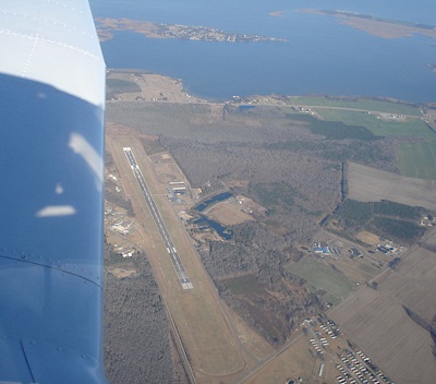
Facility Name: CURRITUCK COUNTY RGNL
City Name: CURRITUCK
County: CURRITUCK
State abbrev: NC
State Name: NORTH CAROLINA
   
Ownership: PUBLICLY OWNED
Use: OPEN TO THE PUBLIC
Owner's Name: COUNTY OF CURRITUCK
Address: 153 COURTHOUSE ROAD, SUITE 800
 CURRITUCK, NC 27929-9653
Owner's Phone: 252-453-8032
  
Manager's Name: WILLIAM NELSON
Address: 264 AIRPORT RD (PHYSICAL ADDRESS), 153 COURTHOUSE ROAD, SUITE 302
 CURRITUCK, NC 27929
Phone: (252) 453-2876; OR 252-453-8032.
   
FAA Region: SOUTHERN
FAA Field Office: MEM
January 2008 - Photo courtesy of Alex Villanueva


Click here for full scale & interactive Sectional view of KONX


Sunrise / Sunset times for CURRITUCK COUNTY RGNL

DateSunriseSunset
04/17/24 Wednesday6:2719:41
04/18/24 Thursday6:2619:41
04/19/24 Friday6:2419:42
04/20/24 Saturday6:2319:43
04/21/24 Sunday6:2219:44
04/22/24 Monday6:2119:45
04/23/24 Tuesday6:1919:46
04/24/24 Wednesday6:1819:47
04/25/24 Thursday6:1719:47
04/26/24 Friday6:1619:48
04/27/24 Saturday6:1519:49
04/28/24 Sunday6:1319:50
04/29/24 Monday6:1219:51
04/30/24 Tuesday6:1119:52

Airport Facilities

Airport Attendance Schedule7 Days A Week 0800-1600; UNATNDD ON ALL STATE HOLIDAYS.
Airport Status OPERATIONAL (This Status can change at any time - please check NOTAMS)
Airport Lighting ScheduleACTVT REIL RWY 05 & 23; MIRL RWY 05/23 AFT SS - CTAF. PAPI RWY 05 & 23 ON CONSLY; TO INCR INTST - CTAF.
Airport Storage AvailableTie Downs
Extra Services AvailableFlight Instruction
Wind IndicatorYES - (lighted)
Control TowerNO
CTAF Frequency122.900
Unicom Frequency
Rotating Beacon ColorWG
Segmented CircleYES
Landing FeeNO

Airport Inspection Data

Airport InspectedSTATE - performed by STATE AERONAUTICAL PERSONNEL
Inspection Date08/20/2021

Airport Services

Type of Fuel AvailableGrade 100LL, JET A-1 (icing inhibitor, freeze point -50C); -10FUEL AVBL 24 HRS WITH CREDIT CARD.
Airframe Repair ServiceMAJOR
Power Plant Repair ServiceMAJOR

Geographic Data

LatitudeN3624.0
LongitudeW07600.9 (ESTIMATED)
Arpt Elevation17ft (SURVEYED)
Magnetic Variation10W
4 miles Sof CURRITUCK
Traffic Pattern Altitude
Sectional ChartWASHINGTON

Aircraft Data

Operations (Reported)YearlyAvg. Daily
General Aviation Transient 1400038
General Aviation Local 350010
Air Taxi 5001
Commerical 00
Commuter 00
Military 700019
Aircraft based on Field
General Aviation Singles 52
General Aviation Multi 5
Jet Aircraft 0
General Aviation Helicopters 1
Military Aircraft 0
Gliders 0
Ultralights 0

FAA Services

FSS on field NO
FSS tie-in RALEIGH
FSS Phone 1-800-WX-BRIEF
Who issues Notams ONX
Notam D service at airport YES
ARTCC Name WASHINGTON

Federal Status

Airport Certification
Aircraft Rescue & Firefighting IndexNone
Airport of EntryNo
Custom Landing RightsNo
Joint Civil/MilitaryNo
Military Landing rightsYES

Federal Agreements

NATIONAL PLAN OF INTEGRATED AIRPORT SYSTEMS (NPIAS)

Remarks

BIRDS & DEER ON AND INVOF ARPT.
FOR CD CTC OCEANA APCH AT 757-433-2968.
Airport Communications & Frequencies:
CTAF Frequency:
122.900
OCEANA Primary Approach Frequencies:  
123.9
266.8
OCEANA Primary Departure Frequencies:  
123.9
266.8
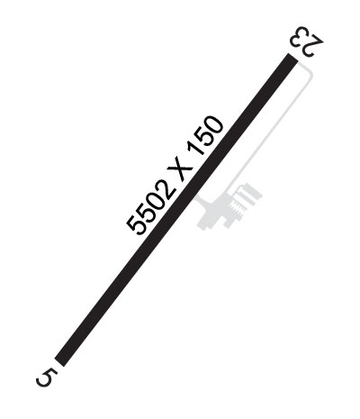
Runway Identifications
Runway Identification: 05/23
Length: 5502 ft
Width: 150 ft
Surface: CONCRETE ASPHALT-GOOD CONDITION
Edge lights: Medium Intensity

Treatment: NONE

 Runway: 05   Runway: 23
Mag heading: 45°Mag heading: 225°
Rwy Slope: .03% UpRwy Slope: -.03% Down
Approach: Approach:
Pattern: Left TrafficPattern: Left Traffic
Markings: NONPRECISION INSTRUMENTMarkings: NONPRECISION INSTRUMENT
Marking Condition: GOODMarking Condition: GOOD
Arresting Dev: Arresting Dev:
Lat & Long: N3623.6  W07601.2Lat. & Long.: N3624.4  W07600.6
Elev: 12.7 ft. MSLElev: 14.1 ft. MSL
TCH: 43 ft. AGLTCH: 41 ft. AGL
Visual Glide Path: 3.00 degreesVisual Glide Path: 3.00 degrees
Displaced Threshold: NoDisplaced Threshold: No
Touchdown Zone: YESTouchdown Zone: YES
Touchdown Elev.: 17.7 feetTouchdown Elev.: 17.7 feet
Visual Glide Slope: 4-Light PAPI on RIGHT side of RunwayVisual Glide Slope: 2-Light PAPI on LEFT side of Runway
RVR Equipment: RVR Equipment:
RVV Equipment: NORVV Equipment: NO
Approach Lights: Approach Lights:
REIL: YESREIL: YES
Centerline Lights: NOCenterline Lights: NO
Touchdown lights: NOTouchdown lights: NO
Runway Category: Runway with a Non-precision Approach having visibility minimums greater than 3/4 mileRunway Category: Runway with a Non-precision Approach having visibility minimums greater than 3/4 mile
Declared Distances: Declared Distances:
Obstructions: PLINEObstructions: TREES
Marked: NOT Marked/LightedMarked: NOT Marked/Lighted
Clearance slope: 30:1Clearance slope: 15:1
Obstruction height: 106 feet AGLObstruction height: 41 feet AGL
Dist. from runway: 3395 feetDist. from runway: 816 feet
Centerline offset: 148 right of centerlineCenterline offset: 56 feet right of centerline
Comments: Comments:
C:7/P: