KOLV

OLIVE BRANCH
OLIVE BRANCH
MS
Time Zone: Central
Lat: N 3458.7
Long: W 08947.2
Elev: 402
Var: +01
Longest Runway: 6000
Clr Del: 121.2/121.3
Dept. ATIS: 119.92
Arr. ATIS: 119.92
AWOS: 119.92
Ground: 121.2
Tower: 125.27

FBO & Flight Services info for KOLV

FBOs: Update your Fuel Prices

  click here  
Olive Branch Aviation is the former Metro Aviation. We have a spacious ramp area, overnight tie-down, competitive fuel prices, and some of the same professional line crew that you've trusted for years. We have a large lobby, conference room, updated crew lounge, vending, and a full kitchen. Jet-A volume discounts available. Call for details.
Ph: 662-895-2978 Fax: 662-895-6520 Freq: 122.95WebsiteE-Mail
                     
Service
Jet
100LL
SAF
MoGas
Fuel Avail: PRIST PREMIXED. Jet-A Volume Discount Available Call for details 662-895-2978
Full4.705.80    Last Update: 04/19/2024 06:18
PRICES GUARANTEED by FBO. *
*24 hr SS 100LL Avbl w/card - Txwy Foxtrot
Self  5.70    
Misc. Info: UNICOM 122.95 Jet A Volume Discount Available Check NOTAM for Holiday Operating HoursAddress: 8000 TERMINAL ROAD   OLIVE BRANCH, MS 38654

MEMPHIS EXEC JETPh: 901-692-1555
-
Freq: 129.05
Service
Jet
100LL
SAF
MoGas
Fuel Avail: PRIST PREMIXED CAA Preferred FBO: ASRI: 129.050
Full4.605.60    Last Update: 04/16/2024 12:57  
Self  5.60    
 Address: 11200 HIGH POINT COVE   OLIVE BRANCH, MS 38654
AWOSPh: 662-893-5906
-
Freq: 119.92  
If you are an FBO, call 1-203-262-1700 to update your info or email: FltPlan.Advertising@garmin.com
Advertise your FBO on FltPlan.com

Runway & Approach Info for KOLV
Rwy
Length
Land Dist**
Approach*
  Rwy
Length
Land Dist**
Approach*
18
6000x100  6000'          
ILS/DME
 109.30 - 180°  
  
36
  6000x100  6000'          
LOC/DME
 111.55 - 000°  
 * only ILS, LOC, LDA, and SDF approaches to a specific runway are shown
** For any Declared Landing Distance Available, please see A/FD or Approach plates
Runway Weight Capability (lbs.) Help
Runway IDSingle WheelDouble WheelDouble Tandem WheelDual Double Wheel
18/36110,000151,000205,000599,000
These numbers are Advisory and are not limits.   The Airport Manager should have more accurate Weight Limits
Approach Charts
Approaches    
Current Weather/Notams
Customs Information Send updates to Support@FltPlan.com
Customs Not Available
Database effective 04/18/2024
Airport Diagram of KOLV
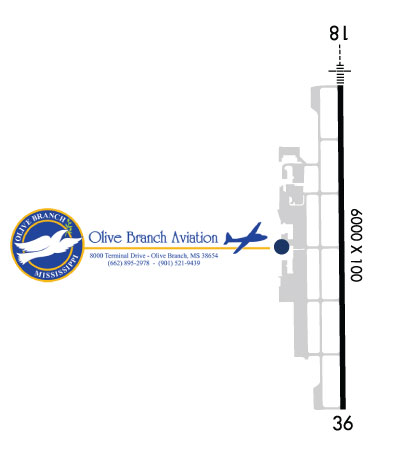
Airport Diagram might not be current.

Facility Name: OLIVE BRANCH/TAYLOR FLD
City Name: OLIVE BRANCH
County: DE SOTO
State abbrev: MS
State Name: MISSISSIPPI
   
Ownership: PUBLICLY OWNED
Use: OPEN TO THE PUBLIC
Owner's Name: CITY OF OLIVE BRANCH
Address: 9200 PIGEON ROOST RD
 OLIVE BRANCH, MS 38654
Owner's Phone: 662-895-2978
  
Manager's Name: DAVID TAYLOR JR
Address: 8000 TERMINAL DR
 OLIVE BRANCH, MS 38654
Phone: 662-895-2978
   
FAA Region: SOUTHERN
FAA Field Office: JAN


Sunrise / Sunset times for OLIVE BRANCH/TAYLOR FLD

DateSunriseSunset
04/18/24 Thursday6:2219:35
04/19/24 Friday6:2119:36
04/20/24 Saturday6:2019:36
04/21/24 Sunday6:1919:37
04/22/24 Monday6:1819:38
04/23/24 Tuesday6:1619:39
04/24/24 Wednesday6:1519:40
04/25/24 Thursday6:1419:40
04/26/24 Friday6:1319:41
04/27/24 Saturday6:1219:42
04/28/24 Sunday6:1119:43
04/29/24 Monday6:1019:44
04/30/24 Tuesday6:0919:44
05/01/24 Wednesday6:0819:45

Airport Facilities

Airport Attendance ScheduleMON-FRI 0600-2100, SAT-SUN 0800-1700; CLSD THANKSGIVING, CHRISTMAS & EASTER.
Airport Status OPERATIONAL (This Status can change at any time - please check NOTAMS)
Airport Lighting ScheduleACTVT MALSR RWY 18 - CTAF.
Airport Storage AvailableTie Downs, Hanger
Extra Services AvailableAvionics, Flight Instruction, Aircraft Rental
Wind IndicatorYES - (unlit)
Control TowerYES
CTAF Frequency125.275
Unicom Frequency122.950
Rotating Beacon ColorWG
Segmented CircleYES
Landing FeeNO

Airport Inspection Data

Airport InspectedSTATE - performed by STATE AERONAUTICAL PERSONNEL
Inspection Date12/01/2023

Airport Services

Type of Fuel AvailableGrade 100LL, JET A (freeze point -40C); -10FUEL AVBL 24 HRS WITH CREDIT CARD.
Airframe Repair ServiceMAJOR
Power Plant Repair ServiceMAJOR

Geographic Data

LatitudeN3458.7
LongitudeW08947.2 (ESTIMATED)
Arpt Elevation401ft (SURVEYED)
Magnetic Variation01W
3 miles NEof OLIVE BRANCH
Traffic Pattern Altitude800
Sectional ChartMEMPHIS

Aircraft Data

Operations (Reported)YearlyAvg. Daily
General Aviation Transient 42529117
General Aviation Local 49863137
Air Taxi 725920
Commerical 50
Commuter 00
Military 9493
Aircraft based on Field
General Aviation Singles 89
General Aviation Multi 15
Jet Aircraft 7
General Aviation Helicopters 1
Military Aircraft 0
Gliders 0
Ultralights 0

FAA Services

FSS on field NO
FSS tie-in GREENWOOD
FSS Phone 1-800-WX-BRIEF
Who issues Notams OLV
Notam D service at airport YES
ARTCC Name MEMPHIS

Federal Status

Airport Certification
Aircraft Rescue & Firefighting IndexNone
Airport of EntryNo
Custom Landing RightsNo
Joint Civil/MilitaryNo
Military Landing rightsNo

Federal Agreements

NATIONAL PLAN OF INTEGRATED AIRPORT SYSTEMS (NPIAS)
ASSURANCES PURSUANT TO TITLE VI, CIVIL RIGHTS ACT OF 1964

Remarks

THIS AIRPORT HAS BEEN SURVEYED BY THE NATIONAL GEODETIC SURVEY.
FIXED DIST MKRS.
READ BACK RQRD OF ALL HOLD BACK INSTRUCTIONS.
TWY H CLSD EXC TO SNGL & LGT TWIN ACFT ONLY.
COURTESY VAN AVBL.
RWY 18/3 6 PCR VALUE: 459/F/D/X/T.
Airport Communications & Frequencies:
ATIS Frequencies:   Hours(local) of Operation: CONTINUOUS
119.925
OLIVE BRANCH Tower Frequencies:   Hours(local) of operation: 0700-2100   
125.275
OLIVE BRANCH Ground Frequencies:
121.2
Clearance Delivery Frequencies:
121.2
121.3 WHEN TWR CLSD
CTAF Frequency:
125.275
Unicom Frequency:
122.950
MEMPHIS Primary Approach Frequencies:  
125.8
338.3
Part-time Approach Frequencies:  
120.075
MEMPHIS Primary Departure Frequencies:  
124.15
385.45
Runway Identifications
Runway Identification: 18/36
Length: 6000 ft
Width: 100 ft
Surface: ASPHALT
Edge lights: High Intensity

Treatment: GROOVED
Weight: PCN 459/F/D/X/T

 Runway: 18   Runway: 36
Mag heading: 181°Mag heading:
Rwy Slope: -.12% DownRwy Slope: .12% Up
Approach: ILS/DMEApproach: LOC/DME
Pattern: Left TrafficPattern: Left Traffic
Markings: PRECISION INSTRUMENTMarkings: NONPRECISION INSTRUMENT
Marking Condition: GOODMarking Condition: GOOD
Arresting Dev: Arresting Dev:
Lat & Long: N3459.2  W08947.2Lat. & Long.: N3458.2  W08947.2
Elev: 401.2 ft. MSLElev: 394.1 ft. MSL
TCH: 51 ft. AGLTCH: 31 ft. AGL
Visual Glide Path: 3.00 degreesVisual Glide Path: 3.00 degrees
Displaced Threshold: NoDisplaced Threshold: No
Touchdown Zone: YESTouchdown Zone: YES
Touchdown Elev.: 401.5 feetTouchdown Elev.: 401.4 feet
Visual Glide Slope: 4-BOX VASI ON LEFT SIDE OF RUNWAYVisual Glide Slope: 4-BOX VASI ON LEFT SIDE OF RUNWAY
RVR Equipment: RVR Equipment:
RVV Equipment: NORVV Equipment: NO
Approach Lights: MALSR - 1,400 foot medium intensity approach lighting system with runway alignment indicator lightsApproach Lights:
REIL: NOREIL: NO
Centerline Lights: NOCenterline Lights: NO
Touchdown lights: NOTouchdown lights: NO
Runway Category: Runway with a Non-precision Approach having visibility minimums greater than 3/4 mileRunway Category: Runway with a Non-precision Approach having visibility minimums greater than 3/4 mile
Declared Distances: Declared Distances:
Obstructions: Obstructions: TREES
Marked: Marked: NOT Marked/Lighted
Clearance slope: 50:1Clearance slope: 37:1
Obstruction height: Obstruction height: 37 feet AGL
Dist. from runway: Dist. from runway: 1590 feet
Centerline offset: Centerline offset: B
Comments: Comments:
C:51/P: