Current Weather/Notams (Metars, TAFs, Notams, NWS Forecast, PIREPS, and nearby weather)
Customs Information Send updates to Support@FltPlan.com
Customs Not Available
Database effective 05/16/2024
Airport Diagram might not be current.
|
| Facility Name: | COLUMBUS MUNI |
| City Name: | COLUMBUS |
| County: | PLATTE |
| State abbrev: | NE |
| State Name: | NEBRASKA |
| | |
| Ownership: | PUBLICLY OWNED |
| Use: | OPEN TO THE PUBLIC |
| Owner's Name: | CITY OF COLUMBUS |
| Address: | P.O. BOX 1677 |
| | COLUMBUS, NE 68602-1677 |
| Owner's Phone: | 402-562-4227; JANELLE KLINE, CITY CLERK |
| | |
| Manager's Name: | ROSS NIEDBALSKI |
| Address: | PO BOX 1677, 1308 BILL BABKA DRIVE, 2765 14TH AVE |
| | COLUMBUS, NE 68602-1677 |
| Phone: | 402-276-5284 |
| | |
| FAA Region: | CENTRAL |
| FAA Field Office: | NONE |
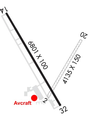
Runway Identifications
Runway Identification: 02/20Length: 4135 ft
Width: 150 ft
Surface: GRASS-FAIR CONDITION
Edge lights: Treatment: NONE
| | Runway: 02 | | Runway: 20 |
| Mag heading: | 27° | Mag heading: | 207° |
| Rwy Slope: | -.03% Down | Rwy Slope: | .03% Up |
| Approach: | | Approach: | |
| Pattern: | Left Traffic | Pattern: | Left Traffic |
| Markings: | | Markings: | |
| Marking Condition: | BOUNDARY MARKERS-G. | Marking Condition: | |
| Arresting Dev: | | Arresting Dev: | |
| Lat & Long: | N4126.6 W09720.4 | Lat. & Long.: | N4127.2 W09720.0 |
| Elev: | 1440.9 ft. MSL | Elev: | 1439.5 ft. MSL |
| TCH: | | TCH: | |
| Visual Glide Path: | | Visual Glide Path: | |
| Displaced Threshold: | 101 feet; RWY 02 END CONES MARK DSPLCD THLD; NOT RWY END. | Displaced Threshold: | No |
| Touchdown Zone: | YES | Touchdown Zone: | YES |
| Touchdown Elev.: | 1441.6 feet | Touchdown Elev.: | 1441.1 feet |
| Visual Glide Slope: | | Visual Glide Slope: | |
| RVR Equipment: | | RVR Equipment: | |
| RVV Equipment: | NO | RVV Equipment: | NO |
| Approach Lights: | | Approach Lights: | |
| REIL: | NO | REIL: | NO |
| Centerline Lights: | NO | Centerline Lights: | NO |
| Touchdown lights: | NO | Touchdown lights: | NO |
| Runway Category: | Runway with a Visual Approach | Runway Category: | Runway with a Visual Approach |
| Declared Distances: | | Declared Distances: | |
| Obstructions: | RWY 02 CLNC SLOPE 30:1 DUE TO GRAIN ELEVATOR LEG 116 FT ABV RWY END 3491 FT FROM DSPLCD THLD; RWY 20 CTR PIVOT THRU APCH DURING IRRIGATION SEASON. | Obstructions: | |
| Marked: | NOT Marked/Lighted | Marked: | |
| Clearance slope: | 20:1 | Clearance slope: | 20:1 |
| Obstruction height: | | Obstruction height: | |
| Dist. from runway: | | Dist. from runway: | |
| Centerline offset: | | Centerline offset: | |
| Comments: | | Comments: | |
Runway Identification: 14/32Length: 6801 ft
Width: 100 ft
Surface: CONCRETE-GOOD CONDITION
Edge lights: Medium IntensityTreatment: NONE
| | Runway: 14 | | Runway: 32 |
| Mag heading: | 147° | Mag heading: | 327° |
| Rwy Slope: | -.10% Down | Rwy Slope: | .10% Up |
| Approach: | LOCALIZER | Approach: | |
| Pattern: | Left Traffic | Pattern: | Left Traffic |
| Markings: | PRECISION INSTRUMENT | Markings: | PRECISION INSTRUMENT |
| Marking Condition: | GOOD | Marking Condition: | GOOD |
| Arresting Dev: | | Arresting Dev: | |
| Lat & Long: | N4127.4 W09721.0 | Lat. & Long.: | N4126.5 W09720.2 |
| Elev: | 1447.3 ft. MSL | Elev: | 1440.5 ft. MSL |
| TCH: | 40 ft. AGL | TCH: | 44 ft. AGL |
| Visual Glide Path: | 3.00 degrees | Visual Glide Path: | 3.00 degrees |
| Displaced Threshold: | No | Displaced Threshold: | 950 feet |
| Touchdown Zone: | YES | Touchdown Zone: | YES |
| Touchdown Elev.: | 1447.3 feet | Touchdown Elev.: | 1443.3 feet |
| Visual Glide Slope: | 4-Light PAPI on LEFT side of Runway | Visual Glide Slope: | 4-BOX VASI ON LEFT SIDE OF RUNWAY |
| RVR Equipment: | | RVR Equipment: | |
| RVV Equipment: | NO | RVV Equipment: | NO |
| Approach Lights: | MALSR - 1,400 foot medium intensity approach lighting system with runway alignment indicator lights | Approach Lights: | |
| REIL: | NO | REIL: | YES |
| Centerline Lights: | NO | Centerline Lights: | NO |
| Touchdown lights: | NO | Touchdown lights: | NO |
| Runway Category: | D | Runway Category: | D |
| Declared Distances: | TORA:6800' TODA:6800' ASDA:6260' LDA:6260' | Declared Distances: | TORA:6800' TODA:6800' ASDA:6800' LDA:5850' |
| Obstructions: | | Obstructions: | TREE |
| Marked: | | Marked: | NOT Marked/Lighted |
| Clearance slope: | 34:1; RWY 32 CLNC SLOPE 37:1 TO DSPLCD THR. | Clearance slope: | 17:1 |
| Obstruction height: | | Obstruction height: | 60 feet AGL |
| Dist. from runway: | | Dist. from runway: | 1275 feet |
| Centerline offset: | | Centerline offset: | 619 feet right of centerline |
| Comments: | | Comments: | |


