Current Weather/Notams (Metars, TAFs, Notams, NWS Forecast, PIREPS, and nearby weather)
Customs Information Send updates to Support@FltPlan.com
Phone 206-396-7784Fax N/AComments 2 hrs advance notice required. Business hrs 0800-1630 Monday-Friday. *Maximum passengers per flight: 15
Database effective 04/18/2024
Airport Diagram might not be current. Facility Name: OLYMPIA RGNL City Name: OLYMPIA County: THURSTON State abbrev: WA State Name: WASHINGTON Ownership: PUBLICLY OWNED Use: OPEN TO THE PUBLIC Owner's Name: PORT OF OLYMPIA Address: 606 COLUMBIA ST NW, SUITE 300 OLYMPIA, WA 98501-0827 Owner's Phone: 360-528-8000 Manager's Name: WARREN HENDRICKSON Address: 7643 OLD HWY 99 SE OLYMPIA, WA 98501 Phone: 360-528-8074 FAA Region: NORTHWEST MOUNTAIN FAA Field Office: SEA
Runway Identifications Help
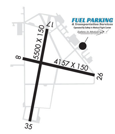
Runway Identification: 08/26 Length: 4157 ftWidth: 150 ftSurface: ASPHALT-GOOD CONDITIONEdge lights: Treatment: NONE Runway: 08 Runway: 26 Mag heading: 89° Mag heading: 269° Rwy Slope: .24% Up Rwy Slope: -.24% Down Approach: Approach: Pattern: Right Traffic Pattern: Left Traffic Markings: BASIC Markings: BASIC Marking Condition: GOOD Marking Condition: GOOD Arresting Dev: Arresting Dev: Lat & Long: N4658.3 W12254.5 Lat. & Long.: N4658.1 W12253.5 Elev: 194.1 ft. MSL Elev: 204.1 ft. MSL TCH: TCH: Visual Glide Path: Visual Glide Path: Displaced Threshold: No Displaced Threshold: No Touchdown Zone: YES Touchdown Zone: YES Touchdown Elev.: 201.5 feet Touchdown Elev.: 205.3 feet Visual Glide Slope: Visual Glide Slope: RVR Equipment: RVR Equipment: RVV Equipment: NO RVV Equipment: NO Approach Lights: Approach Lights: REIL: NO REIL: NO Centerline Lights: NO Centerline Lights: NO Touchdown lights: NO Touchdown lights: NO Runway Category: Runway with a Visual Approach Runway Category: Runway with a Visual Approach Declared Distances: Declared Distances: Obstructions: TREES Obstructions: TREE Marked: NOT Marked/Lighted Marked: NOT Marked/Lighted Clearance slope: 20:1 Clearance slope: 7:1 Obstruction height: 58 feet AGL Obstruction height: 107 feet AGL Dist. from runway: 1360 feet Dist. from runway: 950 feet Centerline offset: 325 left of centerline Centerline offset: 207 feet right of centerline Comments: Comments:
Runway Identification: 17/35 Length: 5500 ftWidth: 150 ftSurface: ASPHALT-GOOD CONDITIONEdge lights: High Intensity Treatment: GROOVED Runway: 17 Runway: 35 Mag heading: 176° Mag heading: 356° Rwy Slope: .11% Up Rwy Slope: -.11% Down Approach: ILS Approach: Pattern: Left Traffic Pattern: Right Traffic Markings: PRECISION INSTRUMENT Markings: NONPRECISION INSTRUMENT Marking Condition: POOR Marking Condition: POOR Arresting Dev: Arresting Dev: Lat & Long: N4658.6 W12254.1 Lat. & Long.: N4657.7 W12254.4 Elev: 196.6 ft. MSL Elev: 202.8 ft. MSL TCH: 54 ft. AGL TCH: 50 ft. AGL Visual Glide Path: 3.00 degrees Visual Glide Path: 3.00 degrees Displaced Threshold: No Displaced Threshold: No Touchdown Zone: YES Touchdown Zone: YES Touchdown Elev.: 207.3 feet Touchdown Elev.: 207.8 feet Visual Glide Slope: 4-Light PAPI on LEFT side of Runway Visual Glide Slope: 4-Light PAPI on LEFT side of Runway RVR Equipment: RVR Equipment: RVV Equipment: NO RVV Equipment: NO Approach Lights: MALSR - 1,400 foot medium intensity approach lighting system with runway alignment indicator lights Approach Lights: REIL: NO REIL: YES Centerline Lights: NO Centerline Lights: NO Touchdown lights: NO Touchdown lights: NO Runway Category: Precision Instrument Runway Runway Category: Runway with a Non-precision Approach having visibility minimums greater than 3/4 mile Declared Distances: Declared Distances: