Current Weather/Notams (Metars, TAFs, Notams, NWS Forecast, PIREPS, and nearby weather)
Customs Information Send updates to Support@FltPlan.com
Customs Not Available
Database effective 04/18/2024
Airport Diagram might not be current.
|
| Facility Name: | CATTARAUGUS COUNTY-OLEAN |
| City Name: | OLEAN |
| County: | CATTARAUGUS |
| State abbrev: | NY |
| State Name: | NEW YORK |
| | |
| Ownership: | PUBLICLY OWNED |
| Use: | OPEN TO THE PUBLIC |
| Owner's Name: | CITY OF OLEAN |
| Address: | MUN BLDG |
| | OLEAN, NY 14760 |
| Owner's Phone: | 716-375-5650 |
| | |
| Manager's Name: | BRUCE CRANDELL |
| Address: | AIRPORT ROAD(5420 HATCH HILL RD) |
| | HINSDALE, NY 14743 |
| Phone: | 716-557-8800 |
| | |
| FAA Region: | EASTERN |
| FAA Field Office: | NYC |
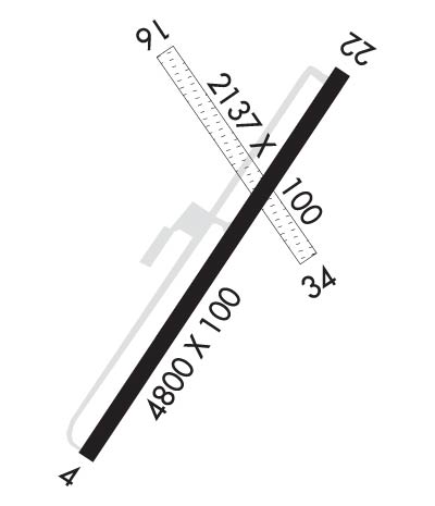
Runway Identifications
Runway Identification: 04/22Length: 4800 ft
Width: 100 ft
Surface: ASPHALT-FAIR CONDITION
Edge lights: High IntensityTreatment: GROOVED
Weight: PCN 32 /F/D/X/T
| | Runway: 04 | | Runway: 22 |
| Mag heading: | 43° | Mag heading: | 223° |
| Rwy Slope: | -.40% Down | Rwy Slope: | .40% Up |
| Approach: | | Approach: | LOCALIZER |
| Pattern: | Left Traffic | Pattern: | Left Traffic |
| Markings: | NONPRECISION INSTRUMENT | Markings: | NONPRECISION INSTRUMENT |
| Marking Condition: | FAIR | Marking Condition: | FAIR |
| Arresting Dev: | | Arresting Dev: | |
| Lat & Long: | N4214.1 W07822.6 | Lat. & Long.: | N4214.8 W07822.0 |
| Elev: | 2131.5 ft. MSL | Elev: | 2112.5 ft. MSL |
| TCH: | 40 ft. AGL | TCH: | 40 ft. AGL |
| Visual Glide Path: | 3.00 degrees | Visual Glide Path: | 3.00 degrees |
| Displaced Threshold: | 100 feet | Displaced Threshold: | 200 feet |
| Touchdown Zone: | YES | Touchdown Zone: | YES |
| Touchdown Elev.: | 2131.7 feet | Touchdown Elev.: | 2131.6 feet |
| Visual Glide Slope: | 2-Light PAPI on LEFT side of Runway | Visual Glide Slope: | 2-Light PAPI on LEFT side of Runway; UNUSBL BYD 5 DEGS LEFT OF CNTRLN. |
| RVR Equipment: | | RVR Equipment: | |
| RVV Equipment: | NO | RVV Equipment: | NO |
| Approach Lights: | | Approach Lights: | |
| REIL: | YES | REIL: | YES |
| Centerline Lights: | NO | Centerline Lights: | NO |
| Touchdown lights: | NO | Touchdown lights: | NO |
| Runway Category: | D | Runway Category: | D |
| Declared Distances: | TORA:4800' TODA:4800' ASDA:4600' LDA:4500' | Declared Distances: | TORA:4800' TODA:4800' ASDA:4700' LDA:4500' |
| Obstructions: | TREES | Obstructions: | TREES |
| Marked: | NOT Marked/Lighted | Marked: | NOT Marked/Lighted |
| Clearance slope: | 1:1; RWY 04 CLNC SLOPE 6:1 TO DTHR. | Clearance slope: | 6:1; RWY 22 CLNC SLOPE 21:1 TO DTHR DUE TO 53 FT TREE, 969 FT. FM RWY END, 585 FT RIGHT. |
| Obstruction height: | 48 feet AGL | Obstruction height: | 14 feet AGL |
| Dist. from runway: | 200 feet | Dist. from runway: | 291 feet |
| Centerline offset: | 484 right of centerline | Centerline offset: | 430 feet left of centerline |
| Comments: | 42 TO 52 FT TREES, 0-200 FT FM RWY END, 475 FT RIGHT. | Comments: | 5-15 FT TREES, 50-130 FT FM RWY END, 435 FT LEFT. |
Runway Identification: 16/34Length: 2117 ft
Width: 100 ft
Surface: GRASS-GOOD CONDITION
Edge lights: Treatment: NONE
| | Runway: 16 | | Runway: 34 |
| Mag heading: | 159° | Mag heading: | 339° |
| Rwy Slope: | -.86% Down | Rwy Slope: | .86% Up |
| Approach: | | Approach: | |
| Pattern: | Left Traffic | Pattern: | Left Traffic |
| Markings: | NONSTANDARD | Markings: | NONSTANDARD |
| Marking Condition: | FAIR; REFLECTIVE EDGE & THLD MARKINGS. | Marking Condition: | FAIR; REFLECTIVE EDGE & THLD MARKINGS. |
| Arresting Dev: | | Arresting Dev: | |
| Lat & Long: | N4214.7 W07822.4 | Lat. & Long.: | N4214.4 W07822.1 |
| Elev: | 2135.3 ft. MSL | Elev: | 2117.0 ft. MSL |
| TCH: | | TCH: | |
| Visual Glide Path: | | Visual Glide Path: | |
| Displaced Threshold: | No | Displaced Threshold: | No |
| Touchdown Zone: | YES | Touchdown Zone: | YES |
| Touchdown Elev.: | 2135.4 feet | Touchdown Elev.: | 2135.4 feet |
| Visual Glide Slope: | | Visual Glide Slope: | |
| RVR Equipment: | | RVR Equipment: | |
| RVV Equipment: | NO | RVV Equipment: | NO |
| Approach Lights: | | Approach Lights: | |
| REIL: | NO | REIL: | NO |
| Centerline Lights: | NO | Centerline Lights: | NO |
| Touchdown lights: | NO | Touchdown lights: | NO |
| Runway Category: | Runway with a Visual Approach | Runway Category: | Runway with a Visual Approach |
| Declared Distances: | | Declared Distances: | |
| Obstructions: | TREE | Obstructions: | |
| Marked: | NOT Marked/Lighted | Marked: | |
| Clearance slope: | 7:1 | Clearance slope: | 20:1 |
| Obstruction height: | 27 feet AGL | Obstruction height: | |
| Dist. from runway: | 196 feet | Dist. from runway: | |
| Centerline offset: | 142 right of centerline | Centerline offset: | |
| Comments: | | Comments: | |
