Current Weather/Notams (Metars, TAFs, Notams, NWS Forecast, PIREPS, and nearby weather)
Customs Information Send updates to Support@FltPlan.com
Customs Not Available
Database effective 04/18/2024
Airport Diagram might not be current.
|
| Facility Name: | DEWITT FLD/OLD TOWN MUNI |
| City Name: | OLD TOWN |
| County: | PENOBSCOT |
| State abbrev: | ME |
| State Name: | MAINE |
| | |
| Ownership: | PUBLICLY OWNED |
| Use: | OPEN TO THE PUBLIC |
| Owner's Name: | CITY OF OLD TOWN |
| Address: | 265 MAIN ST |
| | OLD TOWN, ME 04468 |
| Owner's Phone: | 207-827-3965; ALTN FONE NR: BILL MAYO, CITY MGR 207-827-3965-EXT 201. |
| | |
| Manager's Name: | LANCE FARRAR; LFARRAR@OLD-TOWN.ORG. |
| Address: | 100 AIRPORT RD, PO BOX 558 |
| | OLD TOWN, ME 04468 |
| Phone: | 207-827-7175 |
| | |
| FAA Region: | NEW ENGLAND |
| FAA Field Office: | NONE |
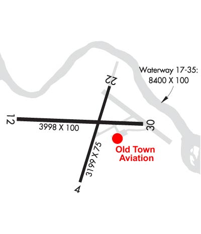
Runway Identifications
Runway Identification: 04/22Length: 2802 ft
Width: 75 ft
Surface: ASPHALT-GOOD CONDITION
Edge lights: Medium IntensityTreatment: NONE
| | Runway: 04 | | Runway: 22 |
| Mag heading: | 37° | Mag heading: | 217° |
| Rwy Slope: | -.13% Down | Rwy Slope: | .13% Up |
| Approach: | | Approach: | |
| Pattern: | Left Traffic | Pattern: | Left Traffic |
| Markings: | NONPRECISION INSTRUMENT | Markings: | NONPRECISION INSTRUMENT |
| Marking Condition: | POOR; FADED. | Marking Condition: | POOR; FADED. |
| Arresting Dev: | | Arresting Dev: | |
| Lat & Long: | N4456.9 W06840.5 | Lat. & Long.: | N4457.3 W06840.3 |
| Elev: | 125.9 ft. MSL | Elev: | 122.2 ft. MSL |
| TCH: | | TCH: | 41 ft. AGL |
| Visual Glide Path: | | Visual Glide Path: | 4.00 degrees |
| Displaced Threshold: | No | Displaced Threshold: | No |
| Touchdown Zone: | YES | Touchdown Zone: | YES |
| Touchdown Elev.: | 126.5 feet | Touchdown Elev.: | 126.5 feet |
| Visual Glide Slope: | | Visual Glide Slope: | 4-Light PAPI on LEFT side of Runway |
| RVR Equipment: | | RVR Equipment: | |
| RVV Equipment: | NO | RVV Equipment: | NO |
| Approach Lights: | | Approach Lights: | |
| REIL: | YES | REIL: | NO |
| Centerline Lights: | NO | Centerline Lights: | NO |
| Touchdown lights: | NO | Touchdown lights: | NO |
| Runway Category: | Runway with a Visual Approach | Runway Category: | Runway with a Non-precision Approach |
| Declared Distances: | | Declared Distances: | |
| Obstructions: | TREES | Obstructions: | |
| Marked: | NOT Marked/Lighted | Marked: | |
| Clearance slope: | 19:1 | Clearance slope: | 20:1 |
| Obstruction height: | 76 feet AGL | Obstruction height: | |
| Dist. from runway: | 1650 feet | Dist. from runway: | |
| Centerline offset: | 280 right of centerline | Centerline offset: | |
| Comments: | | Comments: | |
Runway Identification: 12/30Length: 4001 ft
Width: 75 ft
Surface: ASPHALT-GOOD CONDITION
Edge lights: Medium IntensityTreatment: NONE
| | Runway: 12 | | Runway: 30 |
| Mag heading: | 112° | Mag heading: | 292° |
| Rwy Slope: | -.14% Down | Rwy Slope: | .14% Up |
| Approach: | | Approach: | |
| Pattern: | Left Traffic | Pattern: | Left Traffic |
| Markings: | NONPRECISION INSTRUMENT | Markings: | NONPRECISION INSTRUMENT |
| Marking Condition: | POOR; FADED. | Marking Condition: | POOR; FADED. |
| Arresting Dev: | | Arresting Dev: | |
| Lat & Long: | N4457.2 W06841.0 | Lat. & Long.: | N4457.1 W06840.0 |
| Elev: | 124.7 ft. MSL | Elev: | 119.1 ft. MSL |
| TCH: | | TCH: | 40 ft. AGL |
| Visual Glide Path: | | Visual Glide Path: | 4.00 degrees |
| Displaced Threshold: | No | Displaced Threshold: | 689 feet |
| Touchdown Zone: | YES | Touchdown Zone: | YES |
| Touchdown Elev.: | 125.3 feet | Touchdown Elev.: | 125.3 feet |
| Visual Glide Slope: | | Visual Glide Slope: | 4-Light PAPI on LEFT side of Runway |
| RVR Equipment: | | RVR Equipment: | |
| RVV Equipment: | NO | RVV Equipment: | NO |
| Approach Lights: | | Approach Lights: | |
| REIL: | NO | REIL: | NO |
| Centerline Lights: | NO | Centerline Lights: | NO |
| Touchdown lights: | NO | Touchdown lights: | NO |
| Runway Category: | Runway with a Non-precision Approach | Runway Category: | Runway with a Non-precision Approach |
| Declared Distances: | | Declared Distances: | |
| Obstructions: | TREES | Obstructions: | TREES |
| Marked: | NOT Marked/Lighted | Marked: | NOT Marked/Lighted |
| Clearance slope: | 11:1; 35:1 TO DTHR. | Clearance slope: | 18:1 |
| Obstruction height: | 22 feet AGL | Obstruction height: | 67 feet AGL |
| Dist. from runway: | 442 feet | Dist. from runway: | 1400 feet |
| Centerline offset: | 255 right of centerline | Centerline offset: | 280 feet right of centerline |
| Comments: | | Comments: | |
Runway Identification: 17W/35WLength: 8400 ft
Width: 100 ft
Surface: WATER
Edge lights: Treatment: NONE
| | Runway: 17W | | Runway: 35W |
| Mag heading: | N/A | Mag heading: | N/A |
| Rwy Slope: | .00% | Rwy Slope: | .00% |
| Approach: | | Approach: | |
| Pattern: | Left Traffic | Pattern: | Left Traffic |
| Markings: | | Markings: | |
| Marking Condition: | | Marking Condition: | |
| Arresting Dev: | | Arresting Dev: | |
| Lat & Long: | | Lat. & Long.: | |
| Elev: | 102.0 ft. MSL | Elev: | 102.0 ft. MSL |
| TCH: | | TCH: | |
| Visual Glide Path: | | Visual Glide Path: | |
| Displaced Threshold: | No | Displaced Threshold: | No |
| Touchdown Zone: | NO | Touchdown Zone: | NO |
| Touchdown Elev.: | | Touchdown Elev.: | |
| Visual Glide Slope: | | Visual Glide Slope: | |
| RVR Equipment: | | RVR Equipment: | |
| RVV Equipment: | NO | RVV Equipment: | NO |
| Approach Lights: | | Approach Lights: | |
| REIL: | NO | REIL: | NO |
| Centerline Lights: | NO | Centerline Lights: | NO |
| Touchdown lights: | NO | Touchdown lights: | NO |
| Runway Category: | | Runway Category: | |
| Declared Distances: | | Declared Distances: | |