
| ||||||||||||||||||||||||||||||||||||||||||||
| ||||||||||||||||||||||||||||||||||||||||||||
| ||||||||||||||||||||||||||||||||||||||||||||
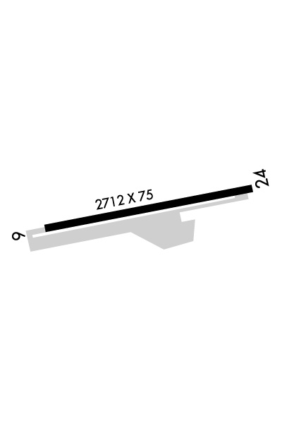
| Rwy | Rwy | |||||||
| 2712x75 | 2712' | 2712x75 | 2712' | |||||
| Runway ID | Single Wheel | Double Wheel | Double Tandem Wheel | Dual Double Wheel |
| 07/25 | 12,000 | N/A | N/A | N/A |
| These numbers are Advisory and are not limits. The Airport Manager should have more accurate Weight Limits | ||||
 Airport Diagram might not be current. | |
| Facility Name: | BOB MAXWELL MEML AIRFIELD |
| City Name: | OCEANSIDE |
| County: | SAN DIEGO |
| State abbrev: | CA |
| State Name: | CALIFORNIA |
| Ownership: | PUBLICLY OWNED |
| Use: | OPEN TO THE PUBLIC |
| Owner's Name: | CITY OF OCEANSIDE |
| Address: | 300 NORTH COAST HIGHWAY |
| OCEANSIDE, CA 92054 | |
| Owner's Phone: | (760) 435-5012 |
| Manager's Name: | ANDREW WIGNOT |
| Address: | 480 AIRPORT ROAD, SUITE 715 |
| OCEANSIDE, CA 92058 | |
| Phone: | (760) 901-4260 |
| FAA Region: | WESTERN-PACIFIC |
| FAA Field Office: | LAX |
| Date | Sunrise | Sunset |
|---|---|---|
| 04/22/24 Monday | 6:10 | 19:26 |
| 04/23/24 Tuesday | 6:09 | 19:27 |
| 04/24/24 Wednesday | 6:08 | 19:27 |
| 04/25/24 Thursday | 6:07 | 19:28 |
| 04/26/24 Friday | 6:06 | 19:29 |
| 04/27/24 Saturday | 6:05 | 19:30 |
| 04/28/24 Sunday | 6:04 | 19:30 |
| 04/29/24 Monday | 6:03 | 19:31 |
| 04/30/24 Tuesday | 6:02 | 19:32 |
| 05/01/24 Wednesday | 6:01 | 19:33 |
| 05/02/24 Thursday | 6:00 | 19:33 |
| 05/03/24 Friday | 5:59 | 19:34 |
| 05/04/24 Saturday | 5:58 | 19:35 |
| 05/05/24 Sunday | 5:57 | 19:36 |
| Airport Attendance Schedule | 7 Days A Week 0900-1700 |
| Airport Status | OPERATIONAL (This Status can change at any time - please check NOTAMS) |
| Airport Lighting Schedule | MIRL RWY 07/25 PRESET LOW INTST; TO INCR INTST ACTVT - CTAF. |
| Airport Storage Available | Tie Downs |
| Extra Services Available | Air Ambulance, Flight Instruction, Parachute Jumping, Aircraft Rental |
| Wind Indicator | YES - (lighted) |
| Control Tower | NO |
| CTAF Frequency | 122.725 |
| Unicom Frequency | 122.725 |
| Rotating Beacon Color | WG |
| Segmented Circle | YES |
| Landing Fee | NO |
| Airport Inspected | STATE - performed by STATE AERONAUTICAL PERSONNEL |
| Inspection Date | 12/14/2023 |
| Type of Fuel Available | Grade 100LL, JET A (freeze point -40C); -10FUEL AVBL 24 HRS 100LL SELF SVC, FULL SVC 0900-1630; JET A 0900-1700. |
| Airframe Repair Service | MINOR |
| Power Plant Repair Service | MAJOR |
| Latitude | N3313.1 |
| Longitude | W11721.1 (ESTIMATED) |
| Arpt Elevation | 28ft (SURVEYED) |
| Magnetic Variation | 13E |
| 2 miles NE | of OCEANSIDE |
| Traffic Pattern Altitude | |
| Sectional Chart | LOS ANGELES |
| Operations (Reported) | Yearly | Avg. Daily |
|---|---|---|
| General Aviation Transient | 14066 | 39 |
| General Aviation Local | 12033 | 33 |
| Air Taxi | 0 | 0 |
| Commerical | 0 | 0 |
| Commuter | 0 | 0 |
| Military | 0 | 0 |
| Aircraft based on Field | |
|---|---|
| General Aviation Singles | 62 |
| General Aviation Multi | 2 |
| Jet Aircraft | 0 |
| General Aviation Helicopters | 4 |
| Military Aircraft | 0 |
| Gliders | 1 |
| Ultralights | 0 |
| FSS on field | NO |
| FSS tie-in | SAN DIEGO |
| FSS Phone | 1-800-WX-BRIEF |
| Who issues Notams | OKB |
| Notam D service at airport | YES |
| ARTCC Name | LOS ANGELES |
| Airport Certification | |
| Aircraft Rescue & Firefighting Index | None |
| Airport of Entry | No |
| Custom Landing Rights | No |
| Joint Civil/Military | No |
| Military Landing rights | No |
| NATIONAL PLAN OF INTEGRATED AIRPORT SYSTEMS (NPIAS) |
| GRANT AGREEMENTS UNDER FAAP/ADAP/AIP |
| ASSURANCES PURSUANT TO TITLE VI, CIVIL RIGHTS ACT OF 1964 |
| FENCE & ROAD WITHIN PRIMARY SFC NORTH SIDE. |
| FOR CD CTC SOCAL APCH AT 800-448-3724. |
| MTS W, NW, SW RWY 07 UP TO 280 FT MSL. |
| UNLGTD MT APRX 160 FT MSL IN APCH ZONE AT 3500 FT FROM W END OF PVMT RWY 07. |
| NOISE ABATEMENT IN EFCT: FLW RIVERBED ALL THE WAY TO COAST PRIOR TO MAKING ANY TURNS. DO NOT FLY OVER ANY HOUSES ALG RIVER BANKS. NO EARLY TURNOUTS PRIOR TO THE OCEAN. SKYDIVING OPS IN EFCT SR-SS DLY. PRCHT LNDG NORTH SIDE OF RWY BTW DOWNWIND AND RWY; NO EFCT ON ACFT TKOF/LNDG THAT FLW TFC PAT. USE CTN WHILE IN THE PAT. |
| DO NOT CONFUSE ROAD SOUTH OF ARPT WITH THE RWY. |
| BIRDS ON AND INVOF ARPT. |
Airport Communications & Frequencies:
| |||||||||||||||||||||
| Runway: 07 | Runway: 25 | ||
| Mag heading: | 67° | Mag heading: | 247° |
| Rwy Slope: | .13% Up | Rwy Slope: | -.13% Down |
| Approach: | Approach: | ||
| Pattern: | Left Traffic | Pattern: | Right Traffic |
| Markings: | NONPRECISION INSTRUMENT | Markings: | NONPRECISION INSTRUMENT |
| Marking Condition: | GOOD | Marking Condition: | GOOD |
| Arresting Dev: | Arresting Dev: | ||
| Lat & Long: | N3313.0 W11721.4 | Lat. & Long.: | N3313.1 W11720.8 |
| Elev: | 24.5 ft. MSL | Elev: | 28.0 ft. MSL |
| TCH: | TCH: | ||
| Visual Glide Path: | Visual Glide Path: | ||
| Displaced Threshold: | No | Displaced Threshold: | No |
| Touchdown Zone: | YES | Touchdown Zone: | YES |
| Touchdown Elev.: | 28.0 feet | Touchdown Elev.: | 28.0 feet |
| Visual Glide Slope: | Visual Glide Slope: | ||
| RVR Equipment: | RVR Equipment: | ||
| RVV Equipment: | NO | RVV Equipment: | NO |
| Approach Lights: | Approach Lights: | ||
| REIL: | NO | REIL: | YES |
| Centerline Lights: | NO | Centerline Lights: | NO |
| Touchdown lights: | NO | Touchdown lights: | NO |
| Runway Category: | Runway with a Non-precision Approach | Runway Category: | Runway with a Non-precision Approach |
| Declared Distances: | Declared Distances: | ||
| Obstructions: | ROAD | Obstructions: | HILL |
| Marked: | NOT Marked/Lighted | Marked: | NOT Marked/Lighted |
| Clearance slope: | 15:1 | Clearance slope: | 24:1 |
| Obstruction height: | 15 feet AGL | Obstruction height: | 210 feet AGL |
| Dist. from runway: | 420 feet | Dist. from runway: | 5300 feet |
| Centerline offset: | 125B | Centerline offset: | |
| Comments: | 8 FT FENCE, ROAD, AND 8+ FT TFC SIGNAL AT 345 FT. | Comments: |
