Current Weather/Notams (Metars, TAFs, Notams, NWS Forecast, PIREPS, and nearby weather)
Customs Information Send updates to Support@FltPlan.com
Customs Not Available
Database effective 05/16/2024
Airport Diagram might not be current.
|
| Facility Name: | WEATHERFORD STAFFORD |
| City Name: | WEATHERFORD |
| County: | CUSTER |
| State abbrev: | OK |
| State Name: | OKLAHOMA |
| | |
| Ownership: | PUBLICLY OWNED |
| Use: | OPEN TO THE PUBLIC |
| Owner's Name: | CITY OF WEATHERFORD |
| Address: | 522 W. RAINEY, P. O. BOX 569 |
| | WEATHERFORD, OK 73096 |
| Owner's Phone: | 580-772-7451 |
| | |
| Manager's Name: | MARK SCHOONMAKER |
| Address: | 3000 LOGAN ROAD |
| | WEATHERFORD, OK 73096 |
| Phone: | 580-774-1971 |
| | |
| FAA Region: | SOUTHWEST |
| FAA Field Office: | AOK |
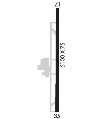
Runway Identifications
Runway Identification: 17/35Length: 5100 ft
Width: 75 ft
Surface: CONCRETE-GOOD CONDITION
Edge lights: Medium IntensityTreatment: NONE
| | Runway: 17 | | Runway: 35 |
| Mag heading: | 174° | Mag heading: | 354° |
| Rwy Slope: | -.02% Down | Rwy Slope: | .02% Up |
| Approach: | | Approach: | |
| Pattern: | Left Traffic | Pattern: | Left Traffic |
| Markings: | NONPRECISION INSTRUMENT | Markings: | NONPRECISION INSTRUMENT |
| Marking Condition: | GOOD | Marking Condition: | GOOD |
| Arresting Dev: | | Arresting Dev: | |
| Lat & Long: | N3533.2 W09840.1 | Lat. & Long.: | N3532.3 W09840.1 |
| Elev: | 1599.6 ft. MSL | Elev: | 1598.8 ft. MSL |
| TCH: | 57 ft. AGL | TCH: | 41 ft. AGL |
| Visual Glide Path: | 3.34 degrees | Visual Glide Path: | 2.92 degrees |
| Displaced Threshold: | No | Displaced Threshold: | No |
| Touchdown Zone: | YES | Touchdown Zone: | YES |
| Touchdown Elev.: | 1605.3 feet | Touchdown Elev.: | 1605.3 feet |
| Visual Glide Slope: | 2-Light PAPI on LEFT side of Runway | Visual Glide Slope: | 2-Light PAPI on LEFT side of Runway |
| RVR Equipment: | | RVR Equipment: | |
| RVV Equipment: | NO | RVV Equipment: | NO |
| Approach Lights: | | Approach Lights: | |
| REIL: | YES | REIL: | YES |
| Centerline Lights: | NO | Centerline Lights: | NO |
| Touchdown lights: | NO | Touchdown lights: | NO |
| Runway Category: | Runway with a Non-precision Approach having visibility minimums greater than 3/4 mile | Runway Category: | Runway with a Non-precision Approach having visibility minimums greater than 3/4 mile |
| Declared Distances: | | Declared Distances: | |
| Obstructions: | TREES | Obstructions: | PLINE |
| Marked: | NOT Marked/Lighted | Marked: | MARKED and LIGHTED |
| Clearance slope: | 9:1 | Clearance slope: | 18:1 |
| Obstruction height: | 46 feet AGL | Obstruction height: | 49 feet AGL |
| Dist. from runway: | 620 feet | Dist. from runway: | 1090 feet |
| Centerline offset: | 280 left of centerline | Centerline offset: | |
| Comments: | | Comments: | |