| |||||||||||||||||||||||||||||||||||||||||||||||||||||||||||||
| |||||||||||||||||||||||||||||||||||||||||||||||||||||||||||||
| |||||||||||||||||||||||||||||||||||||||||||||||||||||||||||||
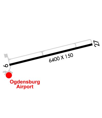
| Rwy | Rwy | |||||||
| 6400x150 | 6400' | 6400x150 | 6400' | 110.70 - 269° | ||||
| Runway ID | Single Wheel | Double Wheel | Double Tandem Wheel | Dual Double Wheel |
| 09/27 | 114,000 | 151,000 | 225,000 | N/A |
| These numbers are Advisory and are not limits. The Airport Manager should have more accurate Weight Limits | ||||
 Airport Diagram might not be current. | |
| Facility Name: | OGDENSBURG INTL |
| City Name: | OGDENSBURG |
| County: | ST LAWRENCE |
| State abbrev: | NY |
| State Name: | NEW YORK |
| Ownership: | PUBLICLY OWNED |
| Use: | OPEN TO THE PUBLIC |
| Owner's Name: | OGDENSBURG BRIDGE & PORT |
| Address: | BRIDGE PLAZA |
| OGDENSBURG, NY 13669 | |
| Owner's Phone: | 315-393-4080 |
| Manager's Name: | CHARLIE GARRELTS |
| Address: | 5840 STATE HWY 812 |
| OGDENSBURG, NY 13669 | |
| Phone: | (315) 869-2676 |
| FAA Region: | EASTERN |
| FAA Field Office: | NYC |
| Date | Sunrise | Sunset |
|---|---|---|
| 04/24/24 Wednesday | 6:01 | 19:59 |
| 04/25/24 Thursday | 6:00 | 20:00 |
| 04/26/24 Friday | 5:58 | 20:01 |
| 04/27/24 Saturday | 5:57 | 20:03 |
| 04/28/24 Sunday | 5:55 | 20:04 |
| 04/29/24 Monday | 5:54 | 20:05 |
| 04/30/24 Tuesday | 5:52 | 20:06 |
| 05/01/24 Wednesday | 5:51 | 20:08 |
| 05/02/24 Thursday | 5:49 | 20:09 |
| 05/03/24 Friday | 5:48 | 20:10 |
| 05/04/24 Saturday | 5:47 | 20:11 |
| 05/05/24 Sunday | 5:45 | 20:12 |
| 05/06/24 Monday | 5:44 | 20:14 |
| 05/07/24 Tuesday | 5:43 | 20:15 |
| Airport Attendance Schedule | NOV 15 - APR 14 7 Days A Week 0600-2030, APR 15 - NOV 14 7 Days A Week 0730-2030; FOR ATTENDANT AFT 2000 CALL 315-869-2676. |
| Airport Status | OPERATIONAL (This Status can change at any time - please check NOTAMS) |
| Airport Lighting Schedule | ACTVT MALSF RWY 27; PAPI RWY 09 & 27; HIRL RWY 09/27; TWY LGTS - CTAF. |
| Airport Storage Available | Tie Downs |
| Extra Services Available | Flight Instruction, Aircraft Rental |
| Wind Indicator | YES - (lighted) |
| Control Tower | NO |
| CTAF Frequency | 122.800 |
| Unicom Frequency | 122.800; ACFT APCHING FROM THE WEST AND LDG ON RWY 09 SHOULD MNT BROCKVILLE ARPT (CNL3) UNICOM ON 123.0. |
| Rotating Beacon Color | WG |
| Segmented Circle | NO |
| Landing Fee | YES |
| Airport Inspected | FEDERAL - performed by FAA AIRPORTS FIELD PERSONNEL |
| Inspection Date | 04/04/2023 |
| Type of Fuel Available | Grade 100LL, JET A (freeze point -40C); -10FUEL AVBL AFT 1600 CALL 315-869-2676. |
| Airframe Repair Service | None |
| Power Plant Repair Service | None |
| Latitude | N4440.9 |
| Longitude | W07527.8 (ESTIMATED) |
| Arpt Elevation | 301ft (SURVEYED) |
| Magnetic Variation | 13W |
| 2 miles SE | of OGDENSBURG |
| Traffic Pattern Altitude | |
| Sectional Chart | MONTREAL |
| Operations (Reported) | Yearly | Avg. Daily |
|---|---|---|
| General Aviation Transient | 195 | 1 |
| General Aviation Local | 1285 | 4 |
| Air Taxi | 1248 | 3 |
| Commerical | 0 | 0 |
| Commuter | 0 | 0 |
| Military | 1500 | 4 |
| Aircraft based on Field | |
|---|---|
| General Aviation Singles | 6 |
| General Aviation Multi | 0 |
| Jet Aircraft | 0 |
| General Aviation Helicopters | 2 |
| Military Aircraft | 0 |
| Gliders | 0 |
| Ultralights | 0 |
| FSS on field | NO |
| FSS tie-in | BURLINGTON |
| FSS Phone | 1-800-WX-BRIEF |
| Who issues Notams | OGS |
| Notam D service at airport | YES |
| ARTCC Name | BOSTON |
| Airport Certification | AIRPORT RECEIVING SCHEDULED AIR CARRIER SERVICE FROM CARRIERS CERTIFICATED BY THE CIVIL AERONAUTICS BOARD; PPR 24 HRS FOR UNSKED ACR OPS WITH MORE THAN 30 PAX SEATS, CALL AMGR. ARFF INDEX B COVERAGE IS AVBL UPON REQ. |
| Aircraft Rescue & Firefighting Index | AIRPORT HAS A CERTIFICATE UNDER CFR PART 139 |
| Airport of Entry | YES; FREE EXCEPT SUN AFTER 0000 & HOL. |
| Custom Landing Rights | No |
| Joint Civil/Military | No |
| Military Landing rights | YES |
| NATIONAL PLAN OF INTEGRATED AIRPORT SYSTEMS (NPIAS) |
| GRANT AGREEMENTS UNDER FAAP/ADAP/AIP |
| ASSURANCES PURSUANT TO TITLE VI, CIVIL RIGHTS ACT OF 1964 |
| BIRDS & DEER ON & INVOF ARPT. |
| FOR CD IF UNA TO CTC ON FSS FREQ, CTC BOSTON ARTCC AT 603-879-6859 . |
| RWY/TWY/APN COND NOT MONITORED OUTSIDE NML ATTENDANCE HRS. |
| RWY 09/2 7 PCR VALUE: 523/F/D/X/T. |
Airport Communications & Frequencies:
| |||||||||
| Runway: 09 | Runway: 27 | ||
| Mag heading: | 89° | Mag heading: | 269° |
| Rwy Slope: | .24% Up | Rwy Slope: | -.24% Down |
| Approach: | Approach: | LOC/DME | |
| Pattern: | Left Traffic | Pattern: | Left Traffic |
| Markings: | NONPRECISION INSTRUMENT | Markings: | NONPRECISION INSTRUMENT |
| Marking Condition: | GOOD | Marking Condition: | GOOD |
| Arresting Dev: | Arresting Dev: | ||
| Lat & Long: | N4440.8 W07528.5 | Lat. & Long.: | N4441.1 W07527.1 |
| Elev: | 286.0 ft. MSL | Elev: | 301.5 ft. MSL |
| TCH: | 46 ft. AGL | TCH: | 45 ft. AGL |
| Visual Glide Path: | 3.00 degrees | Visual Glide Path: | 3.00 degrees |
| Displaced Threshold: | No | Displaced Threshold: | No |
| Touchdown Zone: | YES | Touchdown Zone: | YES |
| Touchdown Elev.: | 291.6 feet | Touchdown Elev.: | 301.8 feet |
| Visual Glide Slope: | 4-Light PAPI on LEFT side of Runway | Visual Glide Slope: | 4-Light PAPI on LEFT side of Runway |
| RVR Equipment: | RVR Equipment: | ||
| RVV Equipment: | NO | RVV Equipment: | NO |
| Approach Lights: | Approach Lights: | MALSF - 1,400 foot medium intensity approach lighting system with sequenced flashers | |
| REIL: | NO | REIL: | NO |
| Centerline Lights: | NO | Centerline Lights: | NO |
| Touchdown lights: | NO | Touchdown lights: | NO |
| Runway Category: | Runway with a Non-precision Approach having visibility minimums greater than 3/4 mile | Runway Category: | Runway with a Non-precision Approach having visibility minimums greater than 3/4 mile |
| Declared Distances: | TORA:6400' TODA:6400' ASDA:6006' LDA:6006' | Declared Distances: | TORA:6400' TODA:6400' ASDA:6035' LDA:6035' |