Click here for more info on on SMS!

KOGM

ONTONAGON COUNTY - SCHUSTER
ONTONAGON
MI
Time Zone: Eastern
Lat: N 4650.7
Long: W 08922.0
Elev: 665.
Var: +03
Longest Runway: 3503
CTAF: 122.9

FBO & Flight Services info for KOGM

FBOs: Update your Fuel Prices

ONTONAGON CO ARPTPh: 906-884-4980
-
Freq: 122.9

If you are an FBO, call 1-203-262-1700 to update your info or email: FltPlan.Advertising@garmin.com
Advertise your FBO on FltPlan.com

Runway & Approach Info for KOGM
Rwy
Length
Land Dist**
Approach*
  Rwy
Length
Land Dist**
Approach*
17
3503x75  3503'          
 
  
35
  3503x75  3503'          
 
 * only ILS, LOC, LDA, and SDF approaches to a specific runway are shown
** For any Declared Landing Distance Available, please see A/FD or Approach plates
Runway Weight Capability (lbs.) Help
Runway IDSingle WheelDouble WheelDouble Tandem WheelDual Double Wheel
17/3512,000N/AN/AN/A
These numbers are Advisory and are not limits.   The Airport Manager should have more accurate Weight Limits
Approach Charts
Approaches    
Current Weather/Notams
Customs Information Send updates to Support@FltPlan.com
Customs Not Available
Database effective 05/16/2024
Airport Diagram of KOGM
Airport Diagram might not be current.

Facility Name: ONTONAGON COUNTY/SCHUSTER FLD
City Name: ONTONAGON
County: ONTONAGON
State abbrev: MI
State Name: MICHIGAN
   
Ownership: PUBLICLY OWNED
Use: OPEN TO THE PUBLIC
Owner's Name: ONTONAGON COUNTY
Address: COURTHOUSE, 725 GREENLAND RD
 ONTONAGON, MI 49953-1400
Owner's Phone: 906-884-4255
  
Manager's Name: LISA LINNA
Address: 35932 AIRPORT RD
 ONTONAGON, MI 49953-9036
Phone: 906-884-6214; CELL 906-390-0027.
   
FAA Region: GREAT LAKES
FAA Field Office: DET


Sunrise / Sunset times for ONTONAGON COUNTY/SCHUSTER FLD

DateSunriseSunset
04/22/24 Monday6:5620:57
04/23/24 Tuesday6:5420:58
04/24/24 Wednesday6:5220:59
04/25/24 Thursday6:5121:01
04/26/24 Friday6:4921:02
04/27/24 Saturday6:4721:03
04/28/24 Sunday6:4621:05
04/29/24 Monday6:4421:06
04/30/24 Tuesday6:4321:07
05/01/24 Wednesday6:4121:09
05/02/24 Thursday6:3921:10
05/03/24 Friday6:3821:11
05/04/24 Saturday6:3621:13
05/05/24 Sunday6:3521:14

Airport Facilities

Airport Attendance ScheduleUNATTENDED
Airport Status OPERATIONAL (This Status can change at any time - please check NOTAMS)
Airport Lighting ScheduleACTVT REIL RWY 17 & 35; PAPI RWY 17 & 35; MIRL RWY 17/35 - CTAF.
Airport Storage AvailableTie Downs
Extra Services AvailableNONE
Wind IndicatorYES - (lighted)
Control TowerNO
CTAF Frequency122.900
Unicom Frequency
Rotating Beacon ColorWG
Segmented CircleYES
Landing FeeNO

Airport Inspection Data

Airport InspectedSTATE - performed by STATE AERONAUTICAL PERSONNEL
Inspection Date09/25/2023

Airport Services

Type of Fuel AvailableGrade 100LL; -10AVBL H24 SELF SVC WITH VISA OR MASTERCARD.
Airframe Repair ServiceNONE
Power Plant Repair ServiceNONE

Geographic Data

LatitudeN4650.7
LongitudeW08922.0 (ESTIMATED)
Arpt Elevation665ft (SURVEYED)
Magnetic Variation03W
3 miles Wof ONTONAGON
Traffic Pattern Altitude
Sectional ChartGREEN BAY

Aircraft Data

Operations (Reported)YearlyAvg. Daily
General Aviation Transient 500
General Aviation Local 1000
Air Taxi 00
Commerical 00
Commuter 00
Military 00
Aircraft based on Field
General Aviation Singles 4
General Aviation Multi 0
Jet Aircraft 0
General Aviation Helicopters 0
Military Aircraft 0
Gliders 0
Ultralights 0

FAA Services

FSS on field NO
FSS tie-in GREEN BAY
FSS Phone 1-800-WX-BRIEF
Who issues Notams GRB
Notam D service at airport YES
ARTCC Name MINNEAPOLIS

Federal Status

Airport Certification
Aircraft Rescue & Firefighting IndexNone
Airport of EntryNo
Custom Landing RightsNo
Joint Civil/MilitaryNo
Military Landing rightsYES

Federal Agreements

NATIONAL PLAN OF INTEGRATED AIRPORT SYSTEMS (NPIAS)
GRANT AGREEMENTS UNDER FAAP/ADAP/AIP
ASSURANCES PURSUANT TO TITLE VI, CIVIL RIGHTS ACT OF 1964

Remarks

DEER & BIRDS ON & INVOF ARPT.
FOR CD CTC MINNEAPOLIS ARTCC AT 651-463-5588.
ADZY ONLY WX AVBL - 4 CLICKS CTAF.
Airport Communications & Frequencies:
CTAF Frequency:
122.900
Remarks
  • APCH/DEP SVC PRVDD BY MINNEAPOLIS ARTCC (ZMP) ON FREQS 133.55/379.1 (HANCOCK RCAG).
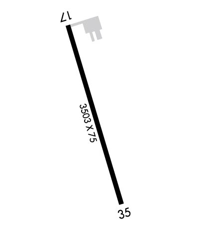
  • Runway Identifications
    Runway Identification: 17/35
    Length: 3503 ft
    Width: 75 ft
    Surface: ASPHALT-GOOD CONDITION
    Edge lights: Medium Intensity

    Treatment: NONE

     Runway: 17   Runway: 35
    Mag heading: 166°Mag heading: 346°
    Rwy Slope: .73% UpRwy Slope: -.73% Down
    Approach: Approach:
    Pattern: Left TrafficPattern: Left Traffic
    Markings: NONPRECISION INSTRUMENTMarkings: NONPRECISION INSTRUMENT
    Marking Condition: GOODMarking Condition: GOOD
    Arresting Dev: Arresting Dev:
    Lat & Long: N4651.0  W08922.1Lat. & Long.: N4650.5  W08921.9
    Elev: 639.5 ft. MSLElev: 665.2 ft. MSL
    TCH: 25 ft. AGLTCH: 25 ft. AGL
    Visual Glide Path: 3.50 degreesVisual Glide Path: 3.50 degrees
    Displaced Threshold: NoDisplaced Threshold: No
    Touchdown Zone: YESTouchdown Zone: YES
    Touchdown Elev.: 661.0 feetTouchdown Elev.: 665.2 feet
    Visual Glide Slope: 2-Light PAPI on LEFT side of RunwayVisual Glide Slope: 2-Light PAPI on LEFT side of Runway
    RVR Equipment: RVR Equipment:
    RVV Equipment: NORVV Equipment: NO
    Approach Lights: Approach Lights:
    REIL: YESREIL: YES
    Centerline Lights: NOCenterline Lights: NO
    Touchdown lights: NOTouchdown lights: NO
    Runway Category: Runway with a Visual ApproachRunway Category: Runway with a Non-precision Approach
    Declared Distances: Declared Distances:
    Obstructions: TREESObstructions: TREES
    Marked: NOT Marked/LightedMarked: NOT Marked/Lighted
    Clearance slope: 18:1Clearance slope: 3:1
    Obstruction height: 52 feet AGLObstruction height: 20 feet AGL
    Dist. from runway: 1162 feetDist. from runway: 260 feet
    Centerline offset: 317 right of centerlineCenterline offset: 257 feet left of centerline
    Comments: Comments: 16 FT TREE, 150 FT DIST, 240 FT L.
    C:1/P: