Click here for more info on on SMS!

KOGA

SEARLE FIELD
OGALLALA
NE
Time Zone: Mountain
Lat: N 4107.2
Long: W 10146.2
Elev: 3279
Var: -07
Longest Runway: 5102
AWOS: 121.27
CTAF: 122.8

FBO & Flight Services info for KOGA

FBOs: Update your Fuel Prices

CITY OF OGALLALAPh: 308-284-3848 Fax: 308-284-4447 Freq: 122.8
Service
Jet
100LL
SAF
MoGas
Full        Last Update: 04/01/2024 15:03

Self5.866.06    
 Address: 150 AIRPORT ROAD SEARLE FIELD   OGALLALA, NE 69153
AWOSPh: 308-284-6573
-
Freq: 121.27  
If you are an FBO, call 1-203-262-1700 to update your info or email: FltPlan.Advertising@garmin.com
Advertise your FBO on FltPlan.com

Runway & Approach Info for KOGA
Rwy
Length
Land Dist**
Approach*
  Rwy
Length
Land Dist**
Approach*
08
5102x75  5102'          
 
  
26
  5102x75  5102'          
 
13
3700x60  3700'          
 
  
31
  3700x60  3700'          
 
 * only ILS, LOC, LDA, and SDF approaches to a specific runway are shown
** For any Declared Landing Distance Available, please see A/FD or Approach plates
Runway Weight Capability (lbs.) Help
Runway IDSingle WheelDouble WheelDouble Tandem WheelDual Double Wheel
08/2612,50012,500N/AN/A
13/3112,50012,500N/AN/A
These numbers are Advisory and are not limits.   The Airport Manager should have more accurate Weight Limits
Approach Charts
Approaches    
Current Weather/Notams
Customs Information Send updates to Support@FltPlan.com
Customs Not Available
Database effective 05/16/2024
Airport Diagram of KOGA
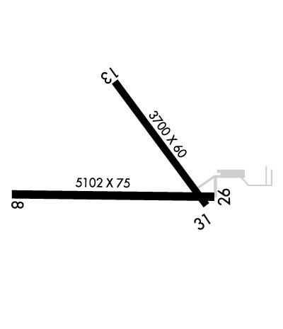
Airport Diagram might not be current.

Facility Name: SEARLE FLD
City Name: OGALLALA
County: KEITH
State abbrev: NE
State Name: NEBRASKA
   
Ownership: PUBLICLY OWNED
Use: OPEN TO THE PUBLIC
Owner's Name: CITY OF OGALLALA
Address: 411 E 2ND STREET
 OGALLALA, NE 69153-2631
Owner's Phone: 308-284-6001
  
Manager's Name: BRUCE SMITH; MIKE CANDY IS AIRPORT ATTENDANT (308) 284-4447. CELL (308) 289-4954. AIRPORT MGR IS BRUCE SMITH, CITY OF OGALLALA, NE., BRUCE.SMITH@OGALLALA-NE.GOV
Address: 411 E 2ND STREET
 OGALLALA, NE 69153-2631
Phone: 308-284-6001
   
FAA Region: CENTRAL
FAA Field Office: NONE


Sunrise / Sunset times for SEARLE FLD

DateSunriseSunset
04/23/24 Tuesday5:5519:36
04/24/24 Wednesday5:5319:38
04/25/24 Thursday5:5219:39
04/26/24 Friday5:5019:40
04/27/24 Saturday5:4919:41
04/28/24 Sunday5:4819:42
04/29/24 Monday5:4619:43
04/30/24 Tuesday5:4519:44
05/01/24 Wednesday5:4419:45
05/02/24 Thursday5:4319:46
05/03/24 Friday5:4119:47
05/04/24 Saturday5:4019:48
05/05/24 Sunday5:3919:49
05/06/24 Monday5:3819:50

Airport Facilities

Airport Attendance ScheduleMON-FRI 0730-1630; FOR ATTENDANT AFTER HOURS CALL (308) 284-4447.
Airport Status OPERATIONAL (This Status can change at any time - please check NOTAMS)
Airport Lighting ScheduleACTVT MIRL RYS 13/31 & 08/26 & PAPI RYS 08, 26 & 31 & VASI RY 13 - CTAF.
Airport Storage AvailableTie Downs, Hanger
Extra Services AvailableCrop Dusting
Wind IndicatorYES - (lighted)
Control TowerNO
CTAF Frequency122.800
Unicom Frequency122.800
Rotating Beacon ColorWG
Segmented CircleYES
Landing FeeNO

Airport Inspection Data

Airport InspectedSTATE - performed by STATE AERONAUTICAL PERSONNEL
Inspection Date06/04/2021

Airport Services

Type of Fuel AvailableGrade 100LL, JET A
Airframe Repair ServiceMAJOR
Power Plant Repair ServiceMAJOR

Geographic Data

LatitudeN4107.2
LongitudeW10146.2 (ESTIMATED)
Arpt Elevation3279ft (SURVEYED)
Magnetic Variation07E
2 miles Wof OGALLALA
Traffic Pattern Altitude
Sectional ChartCHEYENNE

Aircraft Data

Operations (Reported)YearlyAvg. Daily
General Aviation Transient 30008
General Aviation Local 18525
Air Taxi 00
Commerical 00
Commuter 00
Military 780
Aircraft based on Field
General Aviation Singles 11
General Aviation Multi 0
Jet Aircraft 0
General Aviation Helicopters 0
Military Aircraft 0
Gliders 0
Ultralights 0

FAA Services

FSS on field NO
FSS tie-in COLUMBUS
FSS Phone 1-800-WX-BRIEF
Who issues Notams OGA
Notam D service at airport YES
ARTCC Name DENVER

Federal Status

Airport Certification
Aircraft Rescue & Firefighting IndexNone
Airport of EntryNo
Custom Landing RightsNo
Joint Civil/MilitaryNo
Military Landing rightsYES

Federal Agreements

NATIONAL PLAN OF INTEGRATED AIRPORT SYSTEMS (NPIAS)
GRANT AGREEMENTS UNDER FAAP/ADAP/AIP
ASSURANCES PURSUANT TO TITLE VI, CIVIL RIGHTS ACT OF 1964

Remarks

RY 08 DESIGNATED AS CALM WIND RY.
FOR CD IF UNA TO CTC ON FSS FREQ, CTC DENVER ARTCC AT 303-651-4257.
Airport Communications & Frequencies:
CTAF Frequency:
122.800
Unicom Frequency:
122.800
Remarks
  • APCH/DEP CTL SVC PRVDD BY DENVER ARTCC (ZDV) ON FREQS 132.7/397.85 (OGALLALA RCAG).
  • Runway Identifications
    Runway Identification: 08/26
    Length: 5102 ft
    Width: 75 ft
    Surface: CONCRETE-GOOD CONDITION
    Edge lights: Medium Intensity

    Treatment: NONE

     Runway: 08   Runway: 26
    Mag heading: 83°Mag heading: 263°
    Rwy Slope: -.30% DownRwy Slope: .30% Up
    Approach: Approach:
    Pattern: Left TrafficPattern: Left Traffic
    Markings: NONPRECISION INSTRUMENTMarkings: NONPRECISION INSTRUMENT
    Marking Condition: GOODMarking Condition: GOOD
    Arresting Dev: Arresting Dev:
    Lat & Long: N4107.1  W10146.9Lat. & Long.: N4107.1  W10145.8
    Elev: 3260.4 ft. MSLElev: 3245.0 ft. MSL
    TCH: 39 ft. AGLTCH: 48 ft. AGL
    Visual Glide Path: 3.00 degreesVisual Glide Path: 3.00 degrees
    Displaced Threshold: NoDisplaced Threshold: No
    Touchdown Zone: YESTouchdown Zone: YES
    Touchdown Elev.: 3260.4 feetTouchdown Elev.: 3254.4 feet
    Visual Glide Slope: 2-Light PAPI on LEFT side of RunwayVisual Glide Slope: 2-Light PAPI on LEFT side of Runway
    RVR Equipment: RVR Equipment:
    RVV Equipment: NORVV Equipment: NO
    Approach Lights: Approach Lights:
    REIL: NOREIL: NO
    Centerline Lights: NOCenterline Lights: NO
    Touchdown lights: NOTouchdown lights: NO
    Runway Category: Runway with a Non-precision ApproachRunway Category: Runway with a Non-precision Approach
    Declared Distances: Declared Distances:
    Obstructions: OTHER; RWY 08 UNLGTD CNTR PIVOT SYS ROTS THRU APCH DURG IRRIGATION SEASON.Obstructions: POLE
    Marked: NOT Marked/LightedMarked: NOT Marked/Lighted
    Clearance slope: 38:1Clearance slope: 35:1
    Obstruction height: 11 feet AGLObstruction height: 38 feet AGL
    Dist. from runway: 622 feetDist. from runway: 1550 feet
    Centerline offset: Centerline offset:
    Comments: Comments:
    Runway Identification: 13/31
    Length: 3700 ft
    Width: 60 ft
    Surface: CONCRETE
    Edge lights: Medium Intensity

    Treatment: NONE

     Runway: 13   Runway: 31
    Mag heading: 137°Mag heading: 317°
    Rwy Slope: -.93% DownRwy Slope: .93% Up
    Approach: Approach:
    Pattern: Left TrafficPattern: Left Traffic
    Markings: NONPRECISION INSTRUMENTMarkings: NONPRECISION INSTRUMENT
    Marking Condition: GOODMarking Condition: GOOD
    Arresting Dev: Arresting Dev:
    Lat & Long: N4107.6  W10146.2Lat. & Long.: N4107.1  W10145.8
    Elev: 3279.3 ft. MSLElev: 3244.8 ft. MSL
    TCH: 40 ft. AGLTCH: 40 ft. AGL
    Visual Glide Path: 3.50 degreesVisual Glide Path: 3.00 degrees
    Displaced Threshold: NoDisplaced Threshold: No
    Touchdown Zone: YESTouchdown Zone: YES
    Touchdown Elev.: 3279.3 feetTouchdown Elev.: 3271.7 feet
    Visual Glide Slope: 4-BOX VASI ON LEFT SIDE OF RUNWAYVisual Glide Slope: 2-Light PAPI on LEFT side of Runway
    RVR Equipment: RVR Equipment:
    RVV Equipment: NORVV Equipment: NO
    Approach Lights: Approach Lights:
    REIL: NOREIL: NO
    Centerline Lights: NOCenterline Lights: NO
    Touchdown lights: NOTouchdown lights: NO
    Runway Category: Runway with a Non-precision ApproachRunway Category: Runway with a Non-precision Approach
    Declared Distances: Declared Distances:
    Obstructions: ROADObstructions: POLE
    Marked: NOT Marked/LightedMarked: NOT Marked/Lighted
    Clearance slope: 15:1Clearance slope: 23:1
    Obstruction height: 30 feet AGLObstruction height: 19 feet AGL
    Dist. from runway: 670 feetDist. from runway: 650 feet
    Centerline offset: 320 left of centerlineCenterline offset: 305 feet left of centerline
    Comments: Comments:
    C:2/P: