Current Weather/Notams (Metars, TAFs, Notams, NWS Forecast, PIREPS, and nearby weather)
Customs Information Send updates to Support@FltPlan.com
Customs Not Available
Database effective 05/16/2024
Airport Diagram might not be current.
|
| Facility Name: | NORFOLK RGNL/KARL STEFAN MEML FLD |
| City Name: | NORFOLK |
| County: | MADISON |
| State abbrev: | NE |
| State Name: | NEBRASKA |
| | |
| Ownership: | PUBLICLY OWNED |
| Use: | OPEN TO THE PUBLIC |
| Owner's Name: | NORFOLK AIRPORT AUTHORITY |
| Address: | P.O. BOX 1343 |
| | NORFOLK, NE 68702-1343 |
| Owner's Phone: | 402-841-5130 |
| | |
| Manager's Name: | MR ELIJAH MACKIE |
| Address: | P.O. BOX 1343 |
| | NORFOLK, NE 68702-1343 |
| Phone: | 402-841-5130 |
| | |
| FAA Region: | CENTRAL |
| FAA Field Office: | NONE |
Runway Identifications
Runway Identification: 02/20Length: 5801 ft
Width: 100 ft
Surface: ASPHALT-GOOD CONDITION
Edge lights: High IntensityTreatment: POROUS FRICTION COURSE
| | Runway: 02 | | Runway: 20 |
| Mag heading: | 14° | Mag heading: | 194° |
| Rwy Slope: | -.73% Down | Rwy Slope: | .73% Up |
| Approach: | ILS | Approach: | |
| Pattern: | Left Traffic | Pattern: | Left Traffic |
| Markings: | PRECISION INSTRUMENT | Markings: | NONPRECISION INSTRUMENT |
| Marking Condition: | GOOD | Marking Condition: | GOOD |
| Arresting Dev: | | Arresting Dev: | |
| Lat & Long: | N4158.7 W09726.3 | Lat. & Long.: | N4159.6 W09725.8 |
| Elev: | 1572.6 ft. MSL | Elev: | 1530.5 ft. MSL |
| TCH: | 49 ft. AGL | TCH: | 40 ft. AGL |
| Visual Glide Path: | 3.00 degrees | Visual Glide Path: | 3.00 degrees |
| Displaced Threshold: | No | Displaced Threshold: | 297 feet |
| Touchdown Zone: | YES | Touchdown Zone: | YES |
| Touchdown Elev.: | 1572.6 feet | Touchdown Elev.: | 1541.5 feet |
| Visual Glide Slope: | 4-Light PAPI on LEFT side of Runway | Visual Glide Slope: | 4-Light PAPI on LEFT side of Runway |
| RVR Equipment: | | RVR Equipment: | |
| RVV Equipment: | NO | RVV Equipment: | NO |
| Approach Lights: | MALSR - 1,400 foot medium intensity approach lighting system with runway alignment indicator lights | Approach Lights: | |
| REIL: | NO | REIL: | YES |
| Centerline Lights: | NO | Centerline Lights: | NO |
| Touchdown lights: | NO | Touchdown lights: | NO |
| Runway Category: | Precision Instrument Runway | Runway Category: | Runway with a Non-precision Approach having visibility minimums greater than 3/4 mile |
| Declared Distances: | | Declared Distances: | |
| Obstructions: | FENCE | Obstructions: | TREE |
| Marked: | NOT Marked/Lighted | Marked: | NOT Marked/Lighted |
| Clearance slope: | 47:1; RWY 20 CLNC SLOPE 25:1 DUE TO 69 FT TREE 1725 FT FR DSPLCD THR 583 FT RIGHT. | Clearance slope: | 16:1 |
| Obstruction height: | 27 feet AGL | Obstruction height: | 73 feet AGL |
| Dist. from runway: | 1470 feet | Dist. from runway: | 1371 feet |
| Centerline offset: | B | Centerline offset: | 659 feet right of centerline |
| Comments: | | Comments: | |
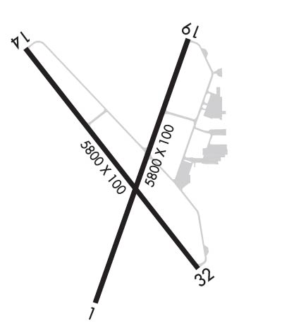
Runway Identification: 14/32Length: 5806 ft
Width: 100 ft
Surface: ASPHALT-GOOD CONDITION
Edge lights: Medium IntensityTreatment: POROUS FRICTION COURSE
| | Runway: 14 | | Runway: 32 |
| Mag heading: | 137° | Mag heading: | 317° |
| Rwy Slope: | .37% Up | Rwy Slope: | -.37% Down |
| Approach: | | Approach: | |
| Pattern: | Left Traffic | Pattern: | Left Traffic |
| Markings: | NONPRECISION INSTRUMENT | Markings: | NONPRECISION INSTRUMENT |
| Marking Condition: | GOOD | Marking Condition: | GOOD |
| Arresting Dev: | | Arresting Dev: | |
| Lat & Long: | N4159.5 W09726.6 | Lat. & Long.: | N4158.8 W09725.8 |
| Elev: | 1542.8 ft. MSL | Elev: | 1564.1 ft. MSL |
| TCH: | 40 ft. AGL | TCH: | 49 ft. AGL |
| Visual Glide Path: | 3.00 degrees | Visual Glide Path: | 3.50 degrees |
| Displaced Threshold: | 287 feet | Displaced Threshold: | 360 feet |
| Touchdown Zone: | YES | Touchdown Zone: | YES |
| Touchdown Elev.: | 1543.4 feet | Touchdown Elev.: | 1559.9 feet |
| Visual Glide Slope: | 4-Light PAPI on LEFT side of Runway | Visual Glide Slope: | 4-Light PAPI on LEFT side of Runway |
| RVR Equipment: | | RVR Equipment: | |
| RVV Equipment: | NO | RVV Equipment: | NO |
| Approach Lights: | | Approach Lights: | |
| REIL: | NO | REIL: | YES |
| Centerline Lights: | NO | Centerline Lights: | NO |
| Touchdown lights: | NO | Touchdown lights: | NO |
| Runway Category: | Runway with a Non-precision Approach having visibility minimums greater than 3/4 mile | Runway Category: | Runway with a Non-precision Approach having visibility minimums greater than 3/4 mile |
| Declared Distances: | TORA:5443' TODA:5800' ASDA:5443' LDA:5160' | Declared Distances: | TORA:5517' TODA:5800' ASDA:5517' LDA:5160' |
| Obstructions: | RR | Obstructions: | TREE |
| Marked: | NOT Marked/Lighted | Marked: | NOT Marked/Lighted |
| Clearance slope: | 24:1; RWY 14 CNTRLN SLOPE TO DSPLCD THR 39:1 DUE TO 86 FT TREE 3384 FT FM DSPLCD THR 50 FT RIGHT. | Clearance slope: | 21:1; RWY 32 CNTRLN SLOPE TO DSPLCD THR 34:1 DUE TO 41 FT TREE 1429 FT FM DSPLCD THR 359 FT RIGHT. |
| Obstruction height: | 28 feet AGL | Obstruction height: | 41 feet AGL |
| Dist. from runway: | 898 feet | Dist. from runway: | 1069 feet |
| Centerline offset: | 427 right of centerline | Centerline offset: | 359 feet right of centerline |
| Comments: | | Comments: | |

