Current Weather/Notams (Metars, TAFs, Notams, NWS Forecast, PIREPS, and nearby weather)
Customs Information Send updates to Support@FltPlan.com
Customs Not Available
Database effective 04/18/2024
Airport Diagram might not be current.
|
| Facility Name: | OAKLEY MUNI |
| City Name: | OAKLEY |
| County: | LOGAN |
| State abbrev: | KS |
| State Name: | KANSAS |
| | |
| Ownership: | PUBLICLY OWNED |
| Use: | OPEN TO THE PUBLIC |
| Owner's Name: | CITY OF OAKLEY |
| Address: | CITY HALL, 209 HUDSON AVE |
| | OAKLEY, KS 67748 |
| Owner's Phone: | 785-671-3136 |
| | |
| Manager's Name: | JOHN HOLZMEISTER |
| Address: | CITY HALL, 209 HUDSON AVE |
| | OAKLEY, KS 67748-6016 |
| Phone: | 785-672-0147; JHOLZMEISTER@FRONTIERAGINC.COM |
| | |
| FAA Region: | CENTRAL |
| FAA Field Office: | NONE |
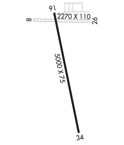
Runway Identifications
Runway Identification: 08/26Length: 2153 ft
Width: 110 ft
Surface: GRASS-GOOD CONDITION
Edge lights: Treatment: NONE
| | Runway: 08 | | Runway: 26 |
| Mag heading: | 83° | Mag heading: | 263° |
| Rwy Slope: | -.10% Down | Rwy Slope: | .10% Up |
| Approach: | | Approach: | |
| Pattern: | Left Traffic | Pattern: | Left Traffic |
| Markings: | NONE | Markings: | NONE |
| Marking Condition: | FAIR | Marking Condition: | FAIR |
| Arresting Dev: | | Arresting Dev: | |
| Lat & Long: | N3907.0 W10049.3 | Lat. & Long.: | N3907.0 W10048.8 |
| Elev: | 3042.0 ft. MSL | Elev: | 3039.9 ft. MSL |
| TCH: | | TCH: | |
| Visual Glide Path: | | Visual Glide Path: | |
| Displaced Threshold: | No | Displaced Threshold: | No |
| Touchdown Zone: | YES | Touchdown Zone: | YES |
| Touchdown Elev.: | 3043.9 feet | Touchdown Elev.: | 3043.9 feet |
| Visual Glide Slope: | | Visual Glide Slope: | |
| RVR Equipment: | | RVR Equipment: | |
| RVV Equipment: | NO | RVV Equipment: | NO |
| Approach Lights: | | Approach Lights: | |
| REIL: | NO | REIL: | NO |
| Centerline Lights: | NO | Centerline Lights: | NO |
| Touchdown lights: | NO | Touchdown lights: | NO |
| Runway Category: | Runway with a Visual Approach | Runway Category: | Runway with a Visual Approach |
| Declared Distances: | | Declared Distances: | |
| Obstructions: | OTHER; C.PIVOT 63 FT HD CNTR OFF RWY. | Obstructions: | ROAD |
| Marked: | NOT Marked/Lighted | Marked: | NOT Marked/Lighted |
| Clearance slope: | 2:1 | Clearance slope: | 15:1 |
| Obstruction height: | 25 feet AGL | Obstruction height: | 17 feet AGL |
| Dist. from runway: | 63 feet | Dist. from runway: | 255 feet |
| Centerline offset: | | Centerline offset: | |
| Comments: | | Comments: | |
Runway Identification: 16/34Length: 5000 ft
Width: 75 ft
Surface: CONCRETE
Edge lights: Medium IntensityTreatment: NONE
| | Runway: 16 | | Runway: 34 |
| Mag heading: | 161° | Mag heading: | 341° |
| Rwy Slope: | -.50% Down | Rwy Slope: | .50% Up |
| Approach: | | Approach: | |
| Pattern: | Left Traffic | Pattern: | Left Traffic |
| Markings: | NONPRECISION INSTRUMENT | Markings: | NONPRECISION INSTRUMENT |
| Marking Condition: | GOOD | Marking Condition: | GOOD |
| Arresting Dev: | | Arresting Dev: | |
| Lat & Long: | N3907.0 W10049.1 | Lat. & Long.: | N3906.2 W10048.9 |
| Elev: | 3045.2 ft. MSL | Elev: | 3020.3 ft. MSL |
| TCH: | 44 ft. AGL | TCH: | 44 ft. AGL |
| Visual Glide Path: | 3.00 degrees | Visual Glide Path: | 3.00 degrees |
| Displaced Threshold: | No | Displaced Threshold: | No |
| Touchdown Zone: | YES | Touchdown Zone: | YES |
| Touchdown Elev.: | 3045.2 feet | Touchdown Elev.: | 3035.3 feet |
| Visual Glide Slope: | 2-Light PAPI on LEFT side of Runway; PAPI UNUSBL BYD 8 DEG RIGHT AND 6 DEG LEFT OF CNTRLN. | Visual Glide Slope: | 2-Light PAPI on LEFT side of Runway; PAPI UNUSBL BYD 8 DEG LEFT OF CNTRLN. |
| RVR Equipment: | | RVR Equipment: | |
| RVV Equipment: | NO | RVV Equipment: | NO |
| Approach Lights: | | Approach Lights: | |
| REIL: | YES | REIL: | YES |
| Centerline Lights: | NO | Centerline Lights: | NO |
| Touchdown lights: | NO | Touchdown lights: | NO |
| Runway Category: | Runway with a Visual Approach | Runway Category: | Runway with a Non-precision Approach having visibility minimums greater than 3/4 mile |
| Declared Distances: | TORA:5000' TODA:5000' ASDA:5000' LDA:5000' | Declared Distances: | TORA:5000' TODA:5000' ASDA:5000' LDA:5000' |
| Obstructions: | BLDG | Obstructions: | TREE |
| Marked: | NOT Marked/Lighted | Marked: | NOT Marked/Lighted |
| Clearance slope: | 18:1 | Clearance slope: | 2:1 |
| Obstruction height: | 30 feet AGL | Obstruction height: | 25 feet AGL |
| Dist. from runway: | 740 feet | Dist. from runway: | 260 feet |
| Centerline offset: | 280 left of centerline | Centerline offset: | 250 feet right of centerline |
| Comments: | | Comments: | |
