Current Weather/Notams (Metars, TAFs, Notams, NWS Forecast, PIREPS, and nearby weather)
Customs Information Send updates to Support@FltPlan.com
Customs Not Available
Database effective 05/16/2024
Airport Diagram might not be current.
|
| Facility Name: | EVELYN SHARP FLD |
| City Name: | ORD |
| County: | VALLEY |
| State abbrev: | NE |
| State Name: | NEBRASKA |
| | |
| Ownership: | PUBLICLY OWNED |
| Use: | OPEN TO THE PUBLIC |
| Owner's Name: | VALLEY COUNTY AIRPORT AUTHORITY; DON VANCURA, CHMN ARPT AUTH. |
| Address: | 81385 HIGHWAY 11 |
| | ORD, NE 68862-5354 |
| Owner's Phone: | (308) 750-5126 |
| | |
| Manager's Name: | DAVE WILLIAMS |
| Address: | 81385 HIGHWAY 11 |
| | ORD, NE 68862-5354 |
| Phone: | 308-750-5126 |
| | |
| FAA Region: | CENTRAL |
| FAA Field Office: | NONE |
Runway Identifications
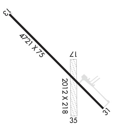
Runway Identification: 13/31Length: 4721 ft
Width: 75 ft
Surface: CONCRETE-GOOD CONDITION
Edge lights: Medium IntensityTreatment: NONE
| | Runway: 13 | | Runway: 31 |
| Mag heading: | 131° | Mag heading: | 311° |
| Rwy Slope: | -.23% Down | Rwy Slope: | .23% Up |
| Approach: | | Approach: | |
| Pattern: | Left Traffic | Pattern: | Left Traffic |
| Markings: | NONPRECISION INSTRUMENT | Markings: | NONPRECISION INSTRUMENT |
| Marking Condition: | GOOD | Marking Condition: | GOOD |
| Arresting Dev: | | Arresting Dev: | |
| Lat & Long: | N4137.7 W09857.5 | Lat. & Long.: | N4137.2 W09856.8 |
| Elev: | 2070.0 ft. MSL | Elev: | 2059.0 ft. MSL |
| TCH: | 44 ft. AGL | TCH: | 32 ft. AGL |
| Visual Glide Path: | 3.00 degrees | Visual Glide Path: | 3.00 degrees |
| Displaced Threshold: | No | Displaced Threshold: | 220 feet |
| Touchdown Zone: | YES | Touchdown Zone: | YES |
| Touchdown Elev.: | 2070.0 feet | Touchdown Elev.: | 2064.1 feet |
| Visual Glide Slope: | 2-Light PAPI on LEFT side of Runway | Visual Glide Slope: | 2-Light PAPI on LEFT side of Runway |
| RVR Equipment: | | RVR Equipment: | |
| RVV Equipment: | NO | RVV Equipment: | NO |
| Approach Lights: | | Approach Lights: | |
| REIL: | YES | REIL: | YES |
| Centerline Lights: | NO | Centerline Lights: | NO |
| Touchdown lights: | NO | Touchdown lights: | NO |
| Runway Category: | Runway with a Non-precision Approach | Runway Category: | Runway with a Non-precision Approach |
| Declared Distances: | | Declared Distances: | |
| Obstructions: | TREE | Obstructions: | POLE |
| Marked: | NOT Marked/Lighted | Marked: | NOT Marked/Lighted |
| Clearance slope: | 24:1; RWY 31 CLNC SLP 29:1 FM DSPLCD THR | Clearance slope: | 17:1 |
| Obstruction height: | 107 feet AGL | Obstruction height: | 34 feet AGL |
| Dist. from runway: | 2820 feet | Dist. from runway: | 797 feet |
| Centerline offset: | 270 right of centerline | Centerline offset: | 308 feet right of centerline |
| Comments: | RWY 13 4 FT FENCE 237 FT RIGHT | Comments: | |
Runway Identification: 17/35Length: 2012 ft
Width: 218 ft
Surface: GRASS-FAIR CONDITION
Edge lights: Treatment: NONE
| | Runway: 17 | | Runway: 35 |
| Mag heading: | 174° | Mag heading: | 354° |
| Rwy Slope: | .00% Down | Rwy Slope: | .00% Up |
| Approach: | | Approach: | |
| Pattern: | Left Traffic | Pattern: | Left Traffic |
| Markings: | | Markings: | |
| Marking Condition: | | Marking Condition: | |
| Arresting Dev: | | Arresting Dev: | |
| Lat & Long: | N4137.5 W09857.0 | Lat. & Long.: | N4137.1 W09857.0 |
| Elev: | 2059.7 ft. MSL | Elev: | 2059.6 ft. MSL |
| TCH: | | TCH: | |
| Visual Glide Path: | | Visual Glide Path: | |
| Displaced Threshold: | No | Displaced Threshold: | No |
| Touchdown Zone: | YES | Touchdown Zone: | YES |
| Touchdown Elev.: | 2061.2 feet | Touchdown Elev.: | 2061.2 feet |
| Visual Glide Slope: | | Visual Glide Slope: | |
| RVR Equipment: | | RVR Equipment: | |
| RVV Equipment: | NO | RVV Equipment: | NO |
| Approach Lights: | | Approach Lights: | |
| REIL: | NO | REIL: | NO |
| Centerline Lights: | NO | Centerline Lights: | NO |
| Touchdown lights: | NO | Touchdown lights: | NO |
| Runway Category: | Runway with a Visual Approach | Runway Category: | Runway with a Visual Approach |
| Declared Distances: | | Declared Distances: | |
| Obstructions: | ROAD | Obstructions: | FENCE; DURING CROP SEASON CORN AT 120' MAKES APCH RATIO 15-1. |
| Marked: | NOT Marked/Lighted | Marked: | NOT Marked/Lighted |
| Clearance slope: | 29:1 | Clearance slope: | 22:1 |
| Obstruction height: | 17 feet AGL | Obstruction height: | 5 feet AGL |
| Dist. from runway: | 495 feet | Dist. from runway: | 110 feet |
| Centerline offset: | | Centerline offset: | |
| Comments: | | Comments: | |

