Click here for more info on on SMS!

KOCQ

J. DOUGLAS BAKE MEMORIAL.
OCONTO
WI
Time Zone: Central
Lat: N 4452.4
Long: W 08754.6
Elev: 604
Var: +03
Longest Runway: 3198
AWOS: 120.92
CTAF: 122.8

FBO & Flight Services info for KOCQ

FBOs: Update your Fuel Prices

BAKE MUNI ARPTPh: 920-834-7727
-
Freq: 122.8
Service
Jet
100LL
SAF
MoGas
Fuel Avail: 24/7 SS FOR 100LL (AVFUEL)
Full        Last Update: 03/29/2024 09:18
PRICES GUARANTEED by FBO. *
*TAX included
Self  4.99    
 Address: 2983 AIRPORT RD   OCONTO, WI 54153
AWOSPh: 920-835-1599
-
Freq: 120.92  
If you are an FBO, call 1-203-262-1700 to update your info or email: FltPlan.Advertising@garmin.com
Advertise your FBO on FltPlan.com

Runway & Approach Info for KOCQ
Rwy
Length
Land Dist**
Approach*
  Rwy
Length
Land Dist**
Approach*
04
1840x150  1840'          
 
  
22
  1840x150  1840'          
 
11
3198x75  3198'          
 
  
29
  3198x75  3198'          
 
 * only ILS, LOC, LDA, and SDF approaches to a specific runway are shown
** For any Declared Landing Distance Available, please see A/FD or Approach plates
Runway Weight Capability (lbs.) Help
Runway IDSingle WheelDouble WheelDouble Tandem WheelDual Double Wheel
04/22N/AN/AN/AN/A
11/2940,00055,00090,000N/A
These numbers are Advisory and are not limits.   The Airport Manager should have more accurate Weight Limits
Approach Charts
Approaches    
Current Weather/Notams
Customs Information Send updates to Support@FltPlan.com
Customs Not Available
Database effective 04/18/2024
Airport Diagram of KOCQ
Airport Diagram might not be current.

Facility Name: OCONTO/J DOUGLAS BAKE MUNI
City Name: OCONTO
County: OCONTO
State abbrev: WI
State Name: WISCONSIN
   
Ownership: PUBLICLY OWNED
Use: OPEN TO THE PUBLIC
Owner's Name: OCONTO CITY AND COUNTY
Address: 1210 MAIN STREET
 OCONTO, WI 54153
Owner's Phone: 920-834-7711
  
Manager's Name: FRANK CALVERT
Address: 2983 AIRPORT RD
 OCONTO, WI 54153
Phone: 920-834-7727
   
FAA Region: GREAT LAKES
FAA Field Office: CHI


Sunrise / Sunset times for OCONTO/J DOUGLAS BAKE MUNI

DateSunriseSunset
04/19/24 Friday5:5919:43
04/20/24 Saturday5:5719:44
04/21/24 Sunday5:5619:45
04/22/24 Monday5:5419:47
04/23/24 Tuesday5:5219:48
04/24/24 Wednesday5:5119:49
04/25/24 Thursday5:4919:50
04/26/24 Friday5:4819:52
04/27/24 Saturday5:4619:53
04/28/24 Sunday5:4519:54
04/29/24 Monday5:4319:55
04/30/24 Tuesday5:4219:57
05/01/24 Wednesday5:4019:58
05/02/24 Thursday5:3919:59

Airport Facilities

Airport Attendance ScheduleMON-FRI IREG
Airport Status OPERATIONAL (This Status can change at any time - please check NOTAMS)
Airport Lighting ScheduleACTVT REIL RWY 11 & 29; MIRL RWY 11/29 - CTAF.
Airport Storage AvailableTie Downs, Hanger
Extra Services AvailableFlight Instruction
Wind IndicatorYES - (lighted)
Control TowerNO
CTAF Frequency122.800
Unicom Frequency122.800
Rotating Beacon ColorWG
Segmented CircleYES
Landing FeeNO

Airport Inspection Data

Airport InspectedSTATE - performed by STATE AERONAUTICAL PERSONNEL
Inspection Date09/14/2021

Airport Services

Type of Fuel AvailableGrade 100LL; -1024 HR FUEL AVBL WITH CREDIT CARD.
Airframe Repair ServiceNONE
Power Plant Repair ServiceNONE

Geographic Data

LatitudeN4452.4
LongitudeW08754.6 (ESTIMATED)
Arpt Elevation604ft (SURVEYED)
Magnetic Variation03W
2 miles SWof OCONTO
Traffic Pattern Altitude
Sectional ChartGREEN BAY

Aircraft Data

Operations (Reported)YearlyAvg. Daily
General Aviation Transient 650018
General Aviation Local 500014
Air Taxi 1000
Commerical 00
Commuter 00
Military 200
Aircraft based on Field
General Aviation Singles 19
General Aviation Multi 0
Jet Aircraft 0
General Aviation Helicopters 0
Military Aircraft 0
Gliders 0
Ultralights 0

FAA Services

FSS on field NO
FSS tie-in GREEN BAY
FSS Phone 1-800-WX-BRIEF
Who issues Notams GRB
Notam D service at airport YES
ARTCC Name MINNEAPOLIS

Federal Status

Airport Certification
Aircraft Rescue & Firefighting IndexNone
Airport of EntryNo
Custom Landing RightsNo
Joint Civil/MilitaryNo
Military Landing rightsYES

Federal Agreements

NATIONAL PLAN OF INTEGRATED AIRPORT SYSTEMS (NPIAS)
GRANT AGREEMENTS UNDER FAAP/ADAP/AIP
ASSURANCES PURSUANT TO TITLE VI, CIVIL RIGHTS ACT OF 1964

Remarks

CONFIRM WINTER RY CONDITIONS & SNOW REMOVAL WITH AMGR 920-834-7727.
MIGRATORY WATERFOWL ON & INVOF ARPT.
FOR CD CTC GREEN BAY APCH AT 920-431-5741, WHEN GREEN BAY APCH CLSD, FOR CD CTC MINNEAPOLIS ARTCC AT 651-463-5588.
RWY 04/2 2 RWY 4/22 NOT PLWD NOV-APR.
Airport Communications & Frequencies:
CTAF Frequency:
122.800
Unicom Frequency:
122.800
Remarks
  • APCH/DEP SVC PRVDD BY MINNEAPOLIS ARTCC ON 125.55/370.9 (GREEN BAY RCAG) WHEN GREEN BAY APCH CLSD.
  • GREEN BAY Primary Approach Frequencies:  
    120.3
    338.2
    GREEN BAY Primary Departure Frequencies:  
    120.3
    338.2
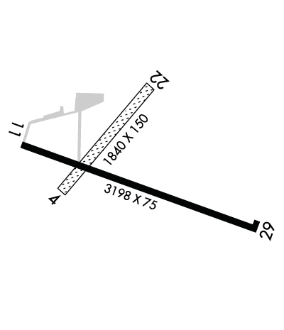
    Runway Identifications
    Runway Identification: 04/22
    Length: 1840 ft
    Width: 150 ft
    Surface: GRASS-FAIR CONDITION
    Edge lights:

    Treatment: NONE

     Runway: 04   Runway: 22
    Mag heading: 44°Mag heading: 224°
    Rwy Slope: -.07% DownRwy Slope: .07% Up
    Approach: Approach:
    Pattern: Left TrafficPattern: Left Traffic
    Markings: NONEMarkings: NONE
    Marking Condition: RWY 04/22 MKD WITH WHITE CONES.Marking Condition:
    Arresting Dev: Arresting Dev:
    Lat & Long: N4452.4  W08754.8Lat. & Long.: N4452.6  W08754.5
    Elev: 602.9 ft. MSLElev: 601.6 ft. MSL
    TCH: TCH:
    Visual Glide Path: Visual Glide Path:
    Displaced Threshold: NoDisplaced Threshold: No
    Touchdown Zone: YESTouchdown Zone: YES
    Touchdown Elev.: 603.7 feetTouchdown Elev.: 603.7 feet
    Visual Glide Slope: Visual Glide Slope:
    RVR Equipment: RVR Equipment:
    RVV Equipment: NORVV Equipment: NO
    Approach Lights: Approach Lights:
    REIL: NOREIL: NO
    Centerline Lights: NOCenterline Lights: NO
    Touchdown lights: NOTouchdown lights: NO
    Runway Category: Runway with a Visual ApproachRunway Category: Runway with a Visual Approach
    Declared Distances: Declared Distances:
    Runway Identification: 11/29
    Length: 3198 ft
    Width: 75 ft
    Surface: ASPHALT
    Edge lights: Medium Intensity

    Treatment: NONE

     Runway: 11   Runway: 29
    Mag heading: 112°Mag heading: 292°
    Rwy Slope: -.09% DownRwy Slope: .09% Up
    Approach: Approach:
    Pattern: Left TrafficPattern: Left Traffic
    Markings: NONPRECISION INSTRUMENTMarkings: NONPRECISION INSTRUMENT
    Marking Condition: GOODMarking Condition: GOOD
    Arresting Dev: Arresting Dev:
    Lat & Long: N4452.5  W08754.9Lat. & Long.: N4452.3  W08754.2
    Elev: 604.3 ft. MSLElev: 601.5 ft. MSL
    TCH: 31 ft. AGLTCH: 31 ft. AGL
    Visual Glide Path: 4.00 degreesVisual Glide Path: 4.00 degrees
    Displaced Threshold: NoDisplaced Threshold: No
    Touchdown Zone: YESTouchdown Zone: YES
    Touchdown Elev.: 604.4 feetTouchdown Elev.: 604.4 feet
    Visual Glide Slope: 2-Light PAPI on LEFT side of RunwayVisual Glide Slope: 2-Light PAPI on LEFT side of Runway; RWY 29 PAPI UNUSBL BYD 8 DEGS RIGHT OF CNTRLN.
    RVR Equipment: RVR Equipment:
    RVV Equipment: NORVV Equipment: NO
    Approach Lights: Approach Lights:
    REIL: YESREIL: YES
    Centerline Lights: NOCenterline Lights: NO
    Touchdown lights: NOTouchdown lights: NO
    Runway Category: Runway with a Non-precision ApproachRunway Category: Runway with a Non-precision Approach
    Declared Distances: Declared Distances:
    C:/P: